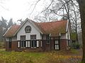
Category:Christinehoeve, Oploo
Jump to navigation
Jump to search
| Object location | | View all coordinates using: OpenStreetMap |
|---|
farmhouse in Sint Anthonis, Netherlands  | |||||
| Upload media | |||||
| Instance of | |||||
|---|---|---|---|---|---|
| Part of | |||||
| Location | Oploo, Land van Cuijk, North Brabant, Netherlands | ||||
| Street address |
| ||||
| Located on street |
| ||||
| Heritage designation |
| ||||
 | |||||
|
This is a category about rijksmonumentcomplex number 519199
|
Christinehoeve:
|
This is a category about rijksmonument number 519200
|
Voormalige villa 'De Groote Slink', thans huize Bronlaak:
|
This is a category about rijksmonument number 519201
|
De Bunthorst, Theekoepel:
|
This is a category about rijksmonument number 519202
|
Huize Bronlaak, Tuinmanswoning:
|
This is a category about rijksmonument number 519250
|
Huize Bronlaak, Dienstwoning, thans in gebruik als boswachterswoning:
|
This is a category about rijksmonument number 519251
|
Huize Bronlaak, Voetgangersbrug:
|
This is a category about rijksmonument number 519252
|
Huize Bronlaak, IJskelder:
|
This is a category about rijksmonument number 519253
|
De Bunthorst, Memorieplaat:
|
This is a category about rijksmonument number 519254
|
De Bunthorst, Grafstenen:
|
This is a category about rijksmonument number 519255
|
| Address |
|
Media in category "Christinehoeve, Oploo"
The following 12 files are in this category, out of 12 total.
-
 Beldienstwoningbronlaak.jpg 1,024 × 768; 134 KB
-
 Boswachterswoningbronlaak.jpg 4,320 × 3,240; 5.88 MB
-
 Boswachterswoningbronlaak2.jpg 1,024 × 768; 187 KB
-
 Boswachterswoningbronlaak3.jpg 1,024 × 768; 181 KB
-
 Bruggroteslinkbronlaak.jpg 4,320 × 3,240; 5.83 MB
-
 Dienstwoningbronlaak.jpg 4,320 × 3,240; 5.82 MB
-
 Dienstwoningbronlaak2.jpg 4,320 × 3,240; 5.74 MB
-
 Hoeve Christine, overzicht - Oploo - 20177382 - RCE.jpg 1,200 × 788; 335 KB
-
 Onderkantvoetgangersbrug.jpg 1,024 × 768; 222 KB
-
 T.T Christinehoeve Oploo (1).JPG 800 × 1,200; 163 KB
-
 T.T Christinehoeve Oploo.JPG 1,200 × 800; 318 KB
-
 Theekoepelbronlaak.jpg 4,320 × 3,240; 5.84 MB


.JPG)
