Category:Chinle Valley
Jump to navigation
Jump to search
valley in Apache County, United States of America  | |||||
| Upload media | |||||
| Instance of | |||||
|---|---|---|---|---|---|
| Location | Apache County, Arizona | ||||
| Located in or next to body of water | |||||
| Length |
| ||||
 | |||||
English: The Chinle Valley — a valley on the Navajo Nation, in Arizona.
- Chinle Creek (Chinle Wash) flows north through the Valley into Utah to a confluence with the San Juan River, of southeast Utah, northwest New Mexico, and southwest Colorado.
- Chinle Valley is located at:
- East of Monument Valley, specifically, the Comb Ridge monocline.
- Black Mesa is the west and southwest border. Chuska Mountains & San Juan Basin are east.
- Four Corners is to the northeast.
- (7) members of the Chinle Formation occur in Chinle Valley
- ------7 & 6----Mesa Redondo Member? and Temple Mountain Member" (youngest)
- ------5----Owl Rock Member
- ------4----Upper Petrified Forest Member (?)
- ------3----Petrified Forest Member
- ------2----Monitor Butte Member
- ------1----en:Shinarump Conglomerate (base member, oldest)
Subcategories
This category has the following 4 subcategories, out of 4 total.
Media in category "Chinle Valley"
The following 11 files are in this category, out of 11 total.
-
 Carrizo Chuska NASA.jpg 1,850 × 1,255; 606 KB
-
 Chinle Wash (16294519576).jpg 3,264 × 2,448; 3.64 MB
-
 CynDChelly L7 2000-09-12.jpg 540 × 540; 165 KB
-
 First Ruin above Chinle Wash (15700576723).jpg 3,264 × 2,448; 3.6 MB
-
 Junction Overlook (16318662551).jpg 3,264 × 2,448; 2.13 MB
-
 NE AZ-NW NM NASA.jpg 990 × 830; 645 KB
-
 Sun Flare Over Alcove At Chinle Wash (218851669).jpeg 2,048 × 1,365; 979 KB
-
 Tséyiʼ sunset (16134586787).jpg 3,264 × 2,448; 2.02 MB
-
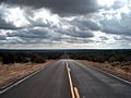
 U.S. 191, Chinle Valley, Navajo Nation, Arizona (14311669330).jpg 4,000 × 3,000; 8.44 MB
-
 US 191 near monument valley.jpg 2,272 × 1,712; 492 KB
-
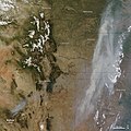 Wallow fire satphoto, June 7, 2011.jpg 720 × 720; 222 KB

.jpg)

.jpg)
.jpg)
.jpeg)
.jpg)
.jpg)


Categories:
- Valleys of Arizona
- Landforms on the Navajo Nation
- Colorado Plateau Navajo section
- Colorado Plateau region of Arizona
- Locations along U.S. Route 191 in Arizona
- San Rafael Group in Arizona
- Glen Canyon Group
- Chinle Formation in Arizona
- Owl Rock Member
- Petrified Forest Member
- Monitor Butte Member
- Shinarump Conglomerate
- Shinarump Conglomerate in Arizona
- Mesa Redondo Member
- Sonsela Member
- Temple Mountain Member
- Locations along U.S. Route 160 in Arizona