Category:Chattonpark Hill
Jump to navigation
Jump to search
Media in category "Chattonpark Hill"
The following 17 files are in this category, out of 17 total.
-
 19th century rock graffiti - geograph.org.uk - 329138.jpg 640 × 480; 136 KB
-
 Barley field below Chattonpark Hill - geograph.org.uk - 1352684.jpg 640 × 480; 149 KB
-
 Chatton Law Camp - geograph.org.uk - 1351629.jpg 640 × 360; 117 KB
-
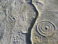
 Cup and Ring marked rock - geograph.org.uk - 573054.jpg 640 × 480; 111 KB
-
 Cup and Ring Markings - geograph.org.uk - 573059.jpg 640 × 480; 102 KB
-
-
 Hillside below Kettley Crag - geograph.org.uk - 1354341.jpg 640 × 480; 168 KB
-
 Kettley Crag rock shelter - geograph.org.uk - 1351708.jpg 640 × 465; 129 KB
-
 Kettley Crag rock shelter - geograph.org.uk - 1354312.jpg 640 × 480; 208 KB
-

-
 The Kettley Stone - geograph.org.uk - 1352659.jpg 640 × 480; 157 KB
-
 The Kettley Stone - geograph.org.uk - 1352670.jpg 640 × 480; 202 KB
-
 The trig point on Chattonpark Hill - geograph.org.uk - 327277.jpg 640 × 480; 83 KB
-

-
 Trig Point on Chattonpark Hill - geograph.org.uk - 1351581.jpg 640 × 480; 141 KB
-
 View north from Kettley Crag - geograph.org.uk - 1352608.jpg 640 × 360; 104 KB
-
 Chatton Park Hill - geograph.org.uk - 1419200.jpg 640 × 480; 112 KB


