Category:Charlotte Amalie Historic District
Jump to navigation
Jump to search
English: The Charlotte Amalie Historic District is a historic district in Charlotte Amalie, St. Thomas, U.S. Virgin Islands.
|
This is a category about a place or building that is listed on the National Register of Historic Places in the United States of America. Its reference number is 76001860. |
historic district in the U.S. Virgin Islands  | |||||
| Upload media | |||||
| Instance of | |||||
|---|---|---|---|---|---|
| Location | Charlotte Amalie, Saint Thomas, United States Virgin Islands, Caribbean | ||||
| Has part(s) |
| ||||
| Heritage designation |
| ||||
| Area |
| ||||
| Elevation above sea level |
| ||||
 | |||||
Subcategories
This category has the following 3 subcategories, out of 3 total.
F
- Fort Christian (28 F)
Media in category "Charlotte Amalie Historic District"
The following 17 files are in this category, out of 17 total.
-
 Charlotte Amalie - Main Street.jpg 1,542 × 1,052; 1,003 KB
-
 Charlotte Amalie 2fer.JPG 4,162 × 2,774; 3.74 MB
-
 Danish West Indies - Charlotte Amalie 01.jpg 2,528 × 1,700; 2.55 MB
-
 Danish West Indies - Charlotte Amalie and Harbor.jpg 2,392 × 1,563; 2.03 MB
-
 Old Bank USVI.JPG 4,320 × 3,240; 3.04 MB
-
 St Tom USVI Old Bank.JPG 3,863 × 2,906; 4.15 MB
-
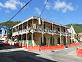
 St. Thomas (USVI) - Street scene.jpg 3,289 × 2,097; 3.97 MB
-
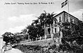 St. Thomas - "Talitha Cumi", Training Home for Girls.jpg 1,625 × 1,039; 586 KB
-
 St. Thomas - Charlotte Amalie.jpg 1,524 × 981; 1.05 MB
-
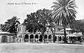 St. Thomas - Custom House.jpg 1,080 × 690; 503 KB
-
 St. Thomas - Main Street (1902).jpg 1,530 × 920; 718 KB
-
 St. Thomas - Main Street.jpg 1,488 × 969; 448 KB
-
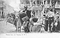 St. Thomas - Market Day.jpg 1,611 × 1,014; 425 KB
-
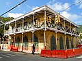
 St. Thomas - The center of Charlotte Amalie.jpg 1,894 × 1,215; 1.19 MB
-
 The Three Rebel Queens of the Virgin Islands.jpg 3,008 × 2,000; 3.01 MB
-
 ThreeQueensSTT.jpg 2,981 × 1,983; 2.98 MB
-
 USVI - Government Hill (1918).jpg 3,295 × 2,084; 4.1 MB


_-_Street_scene.jpg)


.jpg)


.jpg)