Category:Charlie's Walk Mass Path
Jump to navigation
Jump to search
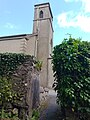
Mass path leading from the Bleach Road to Dunmore Church  | |||||
| Upload media | |||||
| Instance of |
| ||||
|---|---|---|---|---|---|
| Location |
| ||||
 | |||||
The mass path leads from the Bleach Road to Dunmore Church along a lane which is locally known as Charlie's Lane, possibly named after Charles II. who had a connection to people living in Dunmore Cottage. There is still a stile in the back wall of the graveyard, usually a good indicator for a mass path.
Media in category "Charlie's Walk Mass Path"
The following 3 files are in this category, out of 3 total.
-
 Charlie's Walk Dunmore.png 1,080 × 1,080; 2.84 MB
-
 Gate into Dunmore Graveyard.jpg 3,120 × 4,160; 4.57 MB
-
 Squeezer stile in Dunmore.jpg 4,160 × 3,120; 6.71 MB

