Category:Chapelle de Gornévec
Jump to navigation
Jump to search
| Object location | | View all coordinates using: OpenStreetMap |
|---|
|
This building is inscrit au titre des monuments historiques de la France. It is indexed in the base Mérimée, a database of architectural heritage maintained by the French Ministry of Culture, under the reference PA00091552
|
| Object location | | View all coordinates using: OpenStreetMap |
|---|
chapel located in Morbihan, in France  | |||||
| Upload media | |||||
| Instance of | |||||
|---|---|---|---|---|---|
| Location | Plumergat, Morbihan, Brittany, Q88521114, Metropolitan France, France | ||||
| Street address |
| ||||
| Heritage designation |
| ||||
 | |||||
Subcategories
This category has only the following subcategory.
Media in category "Chapelle de Gornévec"
The following 13 files are in this category, out of 13 total.
-
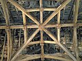
 Charpente Nef Chapelle de Gornévec.jpg 2,304 × 3,072; 5.85 MB
-
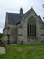 Chevet et clocher Chapelle de Gornévec.jpg 2,304 × 3,072; 4.14 MB
-
 Cloche Brisée Chapelle de Gornévec 2.jpg 2,304 × 3,072; 5.55 MB
-
 Cloche Brisée Chapelle de Gornévec.jpg 2,304 × 3,072; 4.54 MB
-
 Croisée Nef Transept Chapelle de Gornévec.jpg 3,072 × 2,304; 6.25 MB
-
 Crédence Chapelle de Gornévec.jpg 2,304 × 3,072; 4.96 MB
-
 Côté Nord et calvaire Chapelle de Gornévec.jpg 3,072 × 2,304; 5.18 MB
-
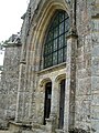 Porche Chapelle de Gornévec.jpg 2,304 × 3,072; 5.11 MB
-
 Sablières-Charpente Chapelle de Gornévec.jpg 3,072 × 2,304; 4.51 MB
-
 Statue Chevet Chapelle de Gornévec.jpg 2,304 × 3,072; 6.48 MB
-
 Statue Chevet Gauche Chapelle de Gornévec.jpg 2,304 × 3,072; 5.91 MB
-
 Statue Droite Choeur Chapelle de Gornévec.jpg 2,304 × 3,072; 6.26 MB
-
 Statue Gauche Choeur Chapelle de Gornévec.jpg 2,304 × 3,072; 5.89 MB


