Category:Chapel St Barbara (Utrecht)
Jump to navigation
Jump to search
| Object location | | View all coordinates using: OpenStreetMap |
|---|
building in the Netherlands   | |||||
| Upload media | |||||
| Instance of |
| ||||
|---|---|---|---|---|---|
| Part of | |||||
| Location | Utrecht, Netherlands | ||||
| Street address |
| ||||
| Located on street |
| ||||
| Architect | |||||
| Heritage designation |
| ||||
| Inception |
| ||||
 | |||||
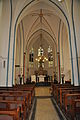
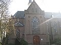
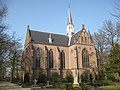
Nederlands: Kapel van de begraafplaats Sint Barbara in Utrecht.
|
This is a category about rijksmonument number 514396
|
| Address |
|
Media in category "Chapel St Barbara (Utrecht)"
The following 11 files are in this category, out of 11 total.
-
 Begraafplaats Sint Barbara Urecht Kapel 01.JPG 2,848 × 4,288; 2.96 MB
-
 Begraafplaats Sint Barbara Urecht Kapel 02.JPG 4,288 × 2,848; 3.38 MB
-
 Begraafplaats Sint Barbara Urecht Kapel 03.JPG 2,848 × 4,288; 3 MB
-
 Begraafplaats Sint Barbara Urecht Kapel 04.JPG 2,848 × 4,288; 3.03 MB
-
 Chapel Saint Barbara cemetery.JPG 3,072 × 2,304; 3.44 MB
-
 Chapel Saint Barbara cemetery2.JPG 3,072 × 2,304; 4.99 MB
-
 Chapel Saint Barbara cemetery3.JPG 3,072 × 2,304; 4.01 MB
-
 Chapel Saint Barbara cemetery4.JPG 3,072 × 2,304; 3.97 MB
-
 De kapel van de begraafplaats Sint Barbara te Utrecht.jpg 5,283 × 6,622; 28.03 MB
-
 De kapel van de begraafplaats Sint Barbara te Utrecht2.jpg 5,696 × 7,080; 33.31 MB
-
 De kapel van de begraafplaats Sint Barbara te Utrecht3.jpg 5,939 × 4,623; 27.84 MB


