Category:Chao Say Tevoda
Jump to navigation
Jump to search
| Object location | | View all coordinates using: OpenStreetMap |
|---|
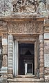
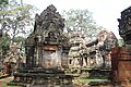
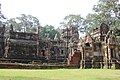
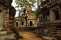
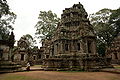
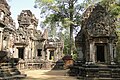
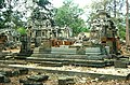
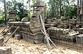
English: Just E of Angkor Thom, two minor temples line the Victory Way: Thommanon (N) and Chao or Chau Say Tevoda (S), both in the Angkor Wat style. They were built in the 12th century, Thommanon early, Chao Say Tevoda somewhat later, and were planned well before Angkor Thom and the Victory Way which date from the end of the 12th century.
archaeological site in Cambodia  | |||||
| Upload media | |||||
| Instance of | |||||
|---|---|---|---|---|---|
| Part of |
| ||||
| Culture | |||||
| Location | Siem Reap, Siem Reap Municipality, Siem Reap Province, Cambodia | ||||
| Founded by | |||||
 | |||||
Media in category "Chao Say Tevoda"
The following 114 files are in this category, out of 114 total.
-
 2016 Angkor, Chau Say Tevoda (01).jpg 5,050 × 2,841; 14.73 MB
-
 2016 Angkor, Chau Say Tevoda (02).jpg 4,910 × 3,273; 16.29 MB
-
 2016 Angkor, Chau Say Tevoda (03).jpg 3,187 × 5,344; 15.38 MB
-
 2016 Angkor, Chau Say Tevoda (04).jpg 2,937 × 4,405; 12.89 MB
-
 2016 Angkor, Chau Say Tevoda (06).jpg 5,021 × 3,347; 14.78 MB
-
 2016 Angkor, Chau Say Tevoda (07).jpg 4,937 × 3,291; 14.68 MB
-
 2016 Angkor, Chau Say Tevoda (08).jpg 5,043 × 3,313; 14.46 MB
-
 2016 Angkor, Chau Say Tevoda (09).jpg 3,328 × 4,822; 15.03 MB
-
 2016 Angkor, Chau Say Tevoda (10).jpg 2,829 × 4,480; 12.42 MB
-
 2016 Angkor, Chau Say Tevoda (11).jpg 4,883 × 3,255; 13.77 MB
-
 607Chau Say Tevoda.jpg 2,000 × 1,500; 794 KB
-
 Ancient Khmer Temple of Chau Say Tevoda - a.jpg 5,184 × 3,456; 4.77 MB
-
 Ancient Khmer Temple of Chau Say Tevoda - b.jpg 5,184 × 3,456; 5.94 MB
-
 Ancient Khmer Temple of Chau Say Tevoda - c.jpg 5,184 × 3,456; 4.46 MB
-
 Ancient Khmer Temple of Chau Say Tevoda - d.jpg 3,456 × 5,184; 4.08 MB
-
 Ancient Khmer Temple of Chau Say Tevoda - e.jpg 5,184 × 3,456; 5.25 MB
-
 Ancient Khmer Temple of Chau Say Tevoda - f.jpg 5,184 × 3,456; 3.84 MB
-
 Ancient Khmer Temple of Chau Say Tevoda - g.jpg 5,184 × 3,456; 5.79 MB
-
 Ancient Khmer Temple of Chau Say Tevoda - h.jpg 5,184 × 3,456; 5.35 MB
-
 Ancient Khmer Temple of Chau Say Tevoda - i.jpg 5,184 × 3,456; 4.54 MB
-
 Ancient Khmer Temple of Chau Say Tevoda - j.jpg 5,184 × 3,456; 4.96 MB
-
 Ancient Khmer Temple of Chau Say Tevoda - k.jpg 5,184 × 3,456; 5.05 MB
-
 Ancient Khmer Temple of Chau Say Tevoda - l.jpg 5,184 × 3,456; 4.53 MB
-
 Ancient Khmer Temple of Chau Say Tevoda - m.jpg 5,184 × 3,456; 3.74 MB
-
 Ancient Khmer Temple of Chau Say Tevoda - n.jpg 5,184 × 3,456; 5.26 MB
-
 Ancient Khmer Temple of Chau Say Tevoda - o.jpg 5,184 × 3,456; 3.8 MB
-
 Ancient Khmer Temple of Chau Say Tevoda - p.jpg 5,184 × 3,456; 3.66 MB
-
 Angkor Chau Say Tevoda 2009.jpg 4,592 × 3,056; 6.51 MB
-
 Angkor Chau Say Tevoda 2009a.jpg 4,592 × 3,056; 7.57 MB
-
 Angkor Chau Say Tevoda 2009b.jpg 4,592 × 3,056; 7.14 MB
-
 Angkor-Chao Say Tevoda-02-2007-gje.jpg 3,072 × 2,048; 3.21 MB
-
 Angkor-Chao Say Tevoda-04-Kran-2007-gje.jpg 3,072 × 2,048; 2.71 MB
-
 Angkor-Chao Say Tevoda-06-Siesta-2007-gje.jpg 2,784 × 1,736; 1.84 MB
-
 Angkor-Chao Say Tevoda-08-Baustelle-2007-gje.jpg 3,072 × 2,048; 3.39 MB
-
 Angkor-Chao Say Tevoda-10-Baustelle-2007-gje.jpg 3,072 × 2,048; 3.45 MB
-
 Angkor-Chao Say Tevoda-12-Baustelle-2007-gje.jpg 3,072 × 2,048; 3.48 MB
-
 Angkor-Chao Say Tevoda-14-Baustelle-2007-gje.jpg 3,072 × 2,048; 3.12 MB
-
 Angkor-Chao Say Tevoda-16-2007-gje.jpg 2,048 × 3,072; 3.61 MB
-
 Angkor-Chao Say Tevoda-18-Giebelfeld-2007-gje.jpg 2,852 × 1,840; 2.4 MB
-
 Cambodge-1000a.jpg 5,760 × 2,495; 10.19 MB
-
 CambodgeChauSayTevoda.JPG 3,072 × 2,048; 5.36 MB
-
 Chao Say Tevoda 2018.jpg 4,032 × 3,024; 2.44 MB
-
 Chao Say Tevoda June 2018.jpg 3,024 × 4,032; 3.05 MB
-
 Chao Say Tevoda, Angkor, Camboya, 2013-08-16, DD 01.JPG 5,277 × 3,204; 7.1 MB
-
 Chao Say Tevoda, Angkor, Camboya, 2013-08-16, DD 02.JPG 4,651 × 3,138; 8.23 MB
-
 Chao Say Tevoda, Angkor, Camboya, 2013-08-16, DD 03.JPG 5,429 × 3,103; 7 MB
-
 Chao Say Tevoda, Angkor, Camboya, 2013-08-16, DD 04.JPG 2,571 × 3,914; 6.03 MB
-
 Chao Say Tevoda, Angkor, Camboya, 2013-08-16, DD 06.JPG 2,816 × 3,986; 7.19 MB
-
 Chao Say Tevoda, Angkor, Camboya, 2013-08-16, DD 07.JPG 2,122 × 3,793; 3.69 MB
-
 Chao Say Tevoda, Angkor, Camboya, 2013-08-16, DD 08.JPG 3,625 × 5,590; 8.33 MB
-
 Chao Say Tevoda, Angkor, Camboya, 2013-08-16, DD 12.JPG 4,217 × 2,899; 8.27 MB
-
 Chao Say Tevoda, Angkor, Camboya, 2013-08-16, DD 13.JPG 3,652 × 5,478; 7.56 MB
-
 Chao Say Tevoda.jpg 640 × 480; 110 KB
-
 Chau Say (9713011145).jpg 5,184 × 3,456; 4.93 MB
-
 Chau Say (9713017291).jpg 5,184 × 3,456; 5.02 MB
-
 Chau Say (9713018469).jpg 3,456 × 5,184; 2.62 MB
-
 Chau Say (9713019527).jpg 3,456 × 5,184; 3.48 MB
-
 Chau Say (9713024231).jpg 5,184 × 3,456; 3.03 MB
-
 Chau Say (9713025515).jpg 3,456 × 5,184; 2.81 MB
-
 Chau Say (9713028435).jpg 3,456 × 5,184; 3.02 MB
-
 Chau Say (9713053551).jpg 5,184 × 3,456; 2.84 MB
-
 Chau Say (9713057401).jpg 3,456 × 5,184; 4.99 MB
-
 Chau Say (9713060835).jpg 5,184 × 3,456; 3.75 MB
-
 Chau Say (9713069983).jpg 3,456 × 5,184; 4.06 MB
-
 Chau Say (9713071071).jpg 3,456 × 5,184; 3.67 MB
-
 Chau Say (9713074861).jpg 3,456 × 5,184; 4.84 MB
-
 Chau Say (9713076293).jpg 5,184 × 3,456; 4.14 MB
-
 Chau Say (9713078411).jpg 5,184 × 3,456; 3.94 MB
-
 Chau Say (9713082475).jpg 3,456 × 5,184; 3.82 MB
-
 Chau Say (9713085433).jpg 5,184 × 3,456; 3.8 MB
-
 Chau Say (9713089295).jpg 5,184 × 3,456; 4.94 MB
-
 Chau Say (9713092961).jpg 5,184 × 3,456; 4.86 MB
-
 Chau Say (9713110617).jpg 5,184 × 3,456; 6.38 MB
-
 Chau Say (9713126745).jpg 5,184 × 3,456; 4.45 MB
-
 Chau Say (9716245750).jpg 5,184 × 3,456; 4.13 MB
-
 Chau Say (9716248856).jpg 5,184 × 3,456; 3.56 MB
-
 Chau Say (9716254442).jpg 3,456 × 5,184; 3.37 MB
-
 Chau Say (9716260876).jpg 5,184 × 3,456; 4.19 MB
-
 Chau Say (9716263102).jpg 5,184 × 3,456; 3.36 MB
-
 Chau Say (9716264898).jpg 5,184 × 3,456; 3.38 MB
-
 Chau Say (9716266540).jpg 5,184 × 3,456; 4.09 MB
-
 Chau Say (9716267844).jpg 5,184 × 3,456; 3.69 MB
-
 Chau Say (9716270500).jpg 3,456 × 5,184; 3.7 MB
-
 Chau Say (9716272112).jpg 5,184 × 3,456; 4.3 MB
-
 Chau Say (9716274104).jpg 5,184 × 3,456; 3.67 MB
-
 Chau Say (9716284266).jpg 5,184 × 3,456; 3.5 MB
-
 Chau Say (9716285808).jpg 5,184 × 3,456; 3.71 MB
-
 Chau Say (9716288908).jpg 5,184 × 3,456; 4.23 MB
-
 Chau Say (9716295898).jpg 5,184 × 3,456; 3.71 MB
-
 Chau Say (9716297728).jpg 5,184 × 3,456; 4.32 MB
-
 Chau Say (9716298940).jpg 5,184 × 3,456; 4.3 MB
-
 Chau Say (9716313254).jpg 5,184 × 3,456; 4.25 MB
-
 Chau Say (9716323768).jpg 5,184 × 3,456; 3.4 MB
-
 Chau Say (9716327368).jpg 5,184 × 3,456; 4.01 MB
-
 Chau Say (9716334872).jpg 5,184 × 3,456; 5 MB
-
 Chau Say (9716337162).jpg 5,184 × 3,456; 6.37 MB
-
 Chau Say (9716339510).jpg 3,456 × 5,184; 3.57 MB
-
 Chau Say (9716340718).jpg 3,456 × 5,184; 3.72 MB
-
 Chau Say (9716356810).jpg 5,184 × 3,456; 4 MB
-
 Chau Say (9716364674).jpg 5,184 × 3,456; 4.65 MB
-
 Chau Say (9716426540).jpg 3,456 × 5,184; 4.6 MB
-
 Chau Say Tevoda 2009.jpg 3,854 × 2,578; 8.48 MB
-
 Chau Say Tevoda 2011-01.jpg 3,968 × 2,232; 5.65 MB
-
 Chau Say Tevoda Temple in Angkor.jpg 1,223 × 816; 318 KB
-
 Chau Say Tevoda2012.jpg 720 × 480; 180 KB
-
 Exposition Angkor - Naissance d'un mythe - Louis Delaporte et le Cambodge - 007.jpg 3,104 × 4,984; 5.52 MB
-
 ICChaoSayTevoda01.jpg 3,246 × 2,144; 1.67 MB
-
 ICChaoSayTevoda02.jpg 3,277 × 2,161; 1.96 MB
-
 ICChaoSayTevoda03.jpg 3,277 × 2,147; 1.56 MB
-
 ICChaoSayTevoda04.jpg 2,170 × 3,304; 1.63 MB
-
 In the Chao Say Temple.jpg 1,223 × 816; 374 KB
-
 នៅប្រាសាទចៅសាយទេវតា - at Chau Say Tevoda.jpg 3,456 × 2,304; 6.6 MB
-
 នៅប្រាសាទចៅសាយទេវតា១ - at Chau Say Tevoda 1.jpg 2,265 × 3,194; 6.77 MB
-
 ស្ត្រីនៅប្រាសាទចៅសាយទេវតា - woman at Chau Say Tevoda.jpg 2,153 × 3,312; 6.46 MB
.jpg)
.jpg)
.jpg)
.jpg)
.jpg)
.jpg)
.jpg)
.jpg)
.jpg)
.jpg)


.jpg)
.jpg)
.jpg)
.jpg)
.jpg)
.jpg)
.jpg)
.jpg)
.jpg)
.jpg)
.jpg)
.jpg)
.jpg)
.jpg)
.jpg)
.jpg)
.jpg)
.jpg)
.jpg)
.jpg)
.jpg)
.jpg)
.jpg)
.jpg)
.jpg)
.jpg)
.jpg)
.jpg)
.jpg)
.jpg)
.jpg)
.jpg)
.jpg)
.jpg)
.jpg)
.jpg)
.jpg)
.jpg)
.jpg)
.jpg)
.jpg)
.jpg)
.jpg)
.jpg)
.jpg)
.jpg)
.jpg)
.jpg)


