Category:Chancery House, Liverpool
Jump to navigation
Jump to search
| Object location | | View all coordinates using: OpenStreetMap |
|---|
building in Liverpool, Merseyside, UK .jpg) | |||||
| Upload media | |||||
| Instance of | |||||
|---|---|---|---|---|---|
| Location | Liverpool, Merseyside, North West England, England | ||||
| Heritage designation |
| ||||
 | |||||
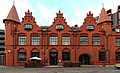
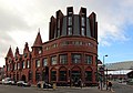
Chancery House occupies 96 Paradise Street and 10 Hanover Street, Liverpool. It is a Grade II listed building dating to 1899 and was formerly the Gordon Smith Institute for Seamen, now restaurants on the ground floor and, with modern additions, an apartment building.
Media in category "Chancery House, Liverpool"
The following 9 files are in this category, out of 9 total.
-
 Chancery House, Liverpool 1.jpg 4,914 × 3,137; 7.67 MB
-
 Chancery House, Liverpool 2.jpg 3,227 × 4,800; 5.8 MB
-
 Chancery House, Liverpool 3.jpg 4,595 × 2,795; 6.41 MB
-
 Chancery House, Liverpool 4.jpg 4,492 × 3,146; 6.1 MB
-
 Chancery House, Liverpool 5.jpg 3,934 × 3,200; 5.42 MB
-
 Chancery House, Liverpool, aerial view.jpg 3,439 × 2,966; 7.01 MB
-
 Chancery House, Paradise Street - geograph.org.uk - 2932956.jpg 640 × 480; 67 KB
-
 Chancery House, Paradise Street, Liverpool (geograph 2860820).jpg 485 × 640; 168 KB
-
 Hanover Street, Liverpool - geograph.org.uk - 2492664.jpg 1,280 × 960; 208 KB


