Category:Carta Hydrographica y Chorographica de las Yslas Filipinas
Jump to navigation
Jump to search
map of the early colonial Philippines, noted for its comprehensiveness  | |||||
| Upload media | |||||
| Instance of | |||||
|---|---|---|---|---|---|
| Depicts | Philippines | ||||
| Location | Madrid, Community of Madrid, Spain | ||||
| Creator | |||||
| Collection | |||||
| Inventory number |
| ||||
| Inception |
| ||||
| Width |
| ||||
| Height |
| ||||
| |||||
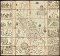
A Hydrographical and Chorographical Chart of the Philippine Islands by the Jesuit Father 'Pedro Murillo Velarde y Bravo (1696–1753) and published in Manila in 1734 The Murillo Velarde map: A relic from 1734 amid the rough seas of 2015
Subcategories
This category has the following 4 subcategories, out of 4 total.
M
- Mapa de las yslas Philipinas (4 F)
Media in category "Carta Hydrographica y Chorographica de las Yslas Filipinas"
The following 8 files are in this category, out of 8 total.
-
 A Hydrographical and Chorographical Chart of the Philippine Islands WDL10089.png 1,096 × 1,024; 2.42 MB
-
 Carta Hydrographica y Chorographica de la Yslas Filipinas MANILA, 1734.jpg 2,000 × 1,870; 2.09 MB
-
 Carta hydrographica y chorographica de las Yslas Filipinas - Biblioteca Nacional de España.jpg 7,251 × 6,770; 13.41 MB
-

-
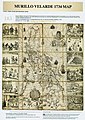 Carta Hydrographica y Chorographica de las Yslas Filipinas.jpg 1,000 × 1,411; 1.78 MB
-
 Carta hydrographica y chorographica delas yslas Filipinas - P. Pedro Murillo Velarde - btv1b5963240f.jpg 14,780 × 13,786; 34.42 MB
-

-
 Carte Hydrographique & Chorographique des Isles Philippines, par ordre de Sa Majesté.jpg 7,760 × 12,316; 14.06 MB


