Category:Carrawburgh
Jump to navigation
Jump to search
Roman site in Northumberland, United Kingdom  | |||||
| Upload media | |||||
| Instance of | |||||
|---|---|---|---|---|---|
| Part of | |||||
| Location | |||||
| Owned by | |||||
| Operator | |||||
| Heritage designation |
| ||||
| Area |
| ||||
| official website | |||||
 | |||||
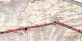
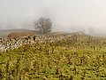
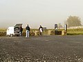
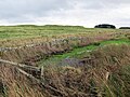
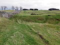
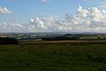
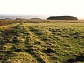
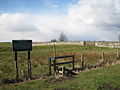
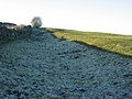
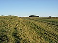
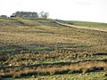
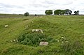
English: Carrawburgh is a settlement in Northumberland. In Roman times, it was the site of a 1.5 hectare (3½ acre) auxiliary fort on Hadrian's Wall called Brocolitia, Procolita, or Brocolita The fort there was the Wall's northernmost point, and just over a mile west of the nearest milecastle, Milecastle 30. It either used the Wall itself as its northern rampart, or was built parallel to it but detached. It certainly postdates both the Wall and the vallum (which it is built across).
Norsk bokmål: I romersk tid var det på stedet en liten festning for støttetroppene, auxilia, på rundt 14 000 m² (3½ acre) i Hadrians mur ved navn Brocolitia, Procolita, eller Brocolita . Festningen der var murens nordligste punkt, og akkurat over en og en halv km vest for det nærmeste milfestning, Milecastle 30 . Festningen i Carrawburgh brukte enten muren i seg selv som en nordlig festningsvoll, eller var bygd parallelt til muren, men frittstående. Den er med sikkerhet datert til etter at muren ble konstruert og dens vallum (som den var bygget på tvers over).
Subcategories
This category has the following 6 subcategories, out of 6 total.
Media in category "Carrawburgh"
The following 71 files are in this category, out of 71 total.
-
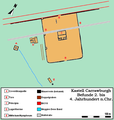 Befundskizze Kastell Carrawburgh.png 754 × 796; 74 KB
-
 7 Brocolitia.png 1,200 × 600; 1.67 MB
-
 B6318 at Brocolitia - geograph.org.uk - 3189151.jpg 640 × 481; 377 KB
-
 B6318 at Carraw - geograph.org.uk - 4137630.jpg 640 × 481; 53 KB
-
 Balineum Carrawburgh.png 740 × 685; 349 KB
-
 Befundplan Coventinaquelle Carrawburgh.png 804 × 1,301; 28 KB
-
 Beyond the west gate of Brocolitia - geograph.org.uk - 1104136.jpg 640 × 480; 106 KB
-
 Brocolitia (2) - geograph.org.uk - 1104124.jpg 640 × 480; 101 KB
-
 Brocolitia (3) - geograph.org.uk - 1104319.jpg 640 × 480; 104 KB
-
 Brocolitia (4) - geograph.org.uk - 1104355.jpg 640 × 480; 117 KB
-
 Brocolitia (5) - geograph.org.uk - 1104372.jpg 640 × 480; 107 KB
-
 Brocolitia (6) - geograph.org.uk - 1104381.jpg 640 × 480; 106 KB
-
 Brocolitia - geograph.org.uk - 1075081.jpg 640 × 480; 102 KB
-
 Brocolitia - geograph.org.uk - 3189111.jpg 640 × 481; 520 KB
-
 Brocolitia - geograph.org.uk - 3189130.jpg 640 × 481; 537 KB
-
 Brocolitia Car Park - geograph.org.uk - 3189143.jpg 640 × 480; 511 KB
-
 Brocolitia Roman Fort Car Park - geograph.org.uk - 72361.jpg 640 × 480; 177 KB
-
 Brocolitia sign - geograph.org.uk - 2253838.jpg 640 × 480; 47 KB
-
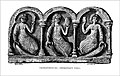
 Bruce Page168 Coventina altar 1885.jpg 1,968 × 1,438; 433 KB
-
 Coventina's Well (2) - geograph.org.uk - 1132068.jpg 640 × 480; 85 KB
-
 Coventina's Well - geograph.org.uk - 1129249.jpg 640 × 480; 119 KB
-
 Coventina's Well west of Brocolitia Roman Fort - geograph.org.uk - 4816412.jpg 1,024 × 768; 278 KB
-
 Coventinas Well.png 1,050 × 649; 111 KB
-

-
 Eastern edge of Brocolitia Roman Fort. - geograph.org.uk - 2607372.jpg 4,000 × 2,522; 7.71 MB
-
 Gate near Brocolitia Roman Fort - geograph.org.uk - 1655561.jpg 640 × 480; 94 KB
-
 Hadrian's Wall Path approaching Brocolitia Fort - geograph.org.uk - 4119515.jpg 4,608 × 3,456; 6.26 MB
-
 Hadrian's Wall Trail east of Brocolitia - geograph.org.uk - 4825086.jpg 1,024 × 768; 265 KB
-
 Hadrian's Wall Trail east of Brocolitia - geograph.org.uk - 4825097.jpg 1,024 × 769; 268 KB
-
 Hope-coventina01.jpg 700 × 445; 69 KB
-
 Hope-coventina01a.jpg 656 × 395; 79 KB
-
-
-

-
 Old quarry east of Brocolitia (3) - geograph.org.uk - 1108101.jpg 640 × 480; 117 KB
-
 Old quarry east of Brocolitia - geograph.org.uk - 1106099.jpg 640 × 480; 103 KB
-
 On the western ramparts of Brocilitia - geograph.org.uk - 1102233.jpg 640 × 480; 104 KB
-

-
 Parking meter at Brocolitia - geograph.org.uk - 1020206.jpg 640 × 480; 72 KB
-

-
 Plantation southeast of Carrawbrough - geograph.org.uk - 1260705.jpg 640 × 480; 106 KB
-

-

-

-

-
 Roman(^) stone near Brocolitia - geograph.org.uk - 1132060.jpg 640 × 480; 116 KB
-
 Standing stone at Coventina's Well - geograph.org.uk - 1132064.jpg 640 × 480; 114 KB
-
 Stile near Brocolitia Roman Fort - geograph.org.uk - 1655505.jpg 640 × 480; 79 KB
-
 The Brocolitia Roman Fort - geograph.org.uk - 2890044.jpg 800 × 600; 136 KB
-

-
 The eastern ramparts of Brocolitia - geograph.org.uk - 1104330.jpg 640 × 480; 104 KB
-
 The Hadrian's Wall Path near Carraw - geograph.org.uk - 3499219.jpg 2,592 × 1,944; 1.49 MB
-

-

-
-

-
 The southern ramparts of Brocolitia - geograph.org.uk - 1102194.jpg 640 × 480; 89 KB
-
 The Vallum near Brocolitia - geograph.org.uk - 1108106.jpg 640 × 480; 85 KB
-
 The Vallum west of Brocolitia - geograph.org.uk - 1102201.jpg 640 × 480; 102 KB
-
 The west gate of Brocolitia (2) - geograph.org.uk - 1104100.jpg 640 × 480; 111 KB
-
 The west gate of Brocolitia - geograph.org.uk - 1075093.jpg 640 × 480; 110 KB
-

-

-

-

-
 The western ramparts of Brocolitia - geograph.org.uk - 1102109.jpg 640 × 480; 71 KB
-
-
 Untersuchung Coventinas Well 1876.png 688 × 417; 376 KB
-
 Walking east towards Brocolitia Fort - geograph.org.uk - 2889980.jpg 800 × 600; 182 KB
-
 Walking towards Brocolitia Fort - geograph.org.uk - 2890039.jpg 800 × 600; 184 KB
-
 ZwischenturmWest Carrawburgh.png 1,008 × 567; 85 KB


_-_geograph.org.uk_-_1104124.jpg)
_-_geograph.org.uk_-_1104319.jpg)
_-_geograph.org.uk_-_1104355.jpg)
_-_geograph.org.uk_-_1104372.jpg)
_-_geograph.org.uk_-_1104381.jpg)


_-_geograph.org.uk_-_1132068.jpg)


_-_geograph.org.uk_-_1260708.jpg)

_-_geograph.org.uk_-_1108101.jpg)


_-_geograph.org.uk_-_1260716.jpg)

_-_geograph.org.uk_-_1260677.jpg)
_-_geograph.org.uk_-_1260683.jpg)
_-_geograph.org.uk_-_1260714.jpg)

_stone_near_Brocolitia_-_geograph.org.uk_-_1132060.jpg)


_-_geograph.org.uk_-_1106094.jpg)

_-_geograph.org.uk_-_1101094.jpg)


_-_geograph.org.uk_-_1104100.jpg)


_-_geograph.org.uk_-_1102110.jpg)
_-_geograph.org.uk_-_1102112.jpg)

.jpg)


