Category:Carlton Scroop
Jump to navigation
Jump to search
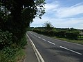
English: Carlton Scroop is a small village of 83 households, located 6 miles north east of Grantham in Lincolnshire. The busy A607 trunk road passes through the centre of the village, on the way to Lincoln. Adjacent villages include Sudbrook, Normanton, Hough-on-the-Hill and Honington.
village in Lincolnshire  | |||||
| Upload media | |||||
| Instance of | |||||
|---|---|---|---|---|---|
| Location | South Kesteven, Lincolnshire, East Midlands, England | ||||
 | |||||
Subcategories
This category has the following 3 subcategories, out of 3 total.
Media in category "Carlton Scroop"
The following 95 files are in this category, out of 95 total.
-
 A field - geograph.org.uk - 6266444.jpg 15,999 × 2,602; 7.96 MB
-
 A607 towards Lincoln - geograph.org.uk - 3076230.jpg 640 × 480; 73 KB
-
 A607 towards Lincoln - geograph.org.uk - 3076243.jpg 640 × 480; 107 KB
-
 A607, Carlton Scroop - geograph.org.uk - 4208491.jpg 640 × 480; 282 KB
-
 Access road to Carlton Ashes Farm - geograph.org.uk - 3952749.jpg 4,000 × 3,000; 2.09 MB
-
 Ash tree and Red House - geograph.org.uk - 5182415.jpg 1,024 × 768; 281 KB
-
 Autumn hedgerow - geograph.org.uk - 281522.jpg 640 × 427; 108 KB
-
 Bus stop and shelter, Carlton Scroop - geograph.org.uk - 4890843.jpg 4,928 × 3,264; 6.74 MB
-
 Carlton Ashes - geograph.org.uk - 1624435.jpg 640 × 426; 88 KB
-
 Carlton Scroop - geograph.org.uk - 1273834.jpg 640 × 427; 75 KB
-
 Carlton Scroop Heath - geograph.org.uk - 4421204.jpg 1,024 × 683; 158 KB
-
 Carlton Scroop Heath - geograph.org.uk - 4421219.jpg 1,024 × 683; 201 KB
-
 Carlton Scroop, Main Street - geograph.org.uk - 4208493.jpg 640 × 480; 295 KB
-
 Charity Street - geograph.org.uk - 6351768.jpg 6,240 × 4,160; 5.71 MB
-
 Charity Street, Carlton Scroop - geograph.org.uk - 3127889.jpg 1,024 × 628; 148 KB
-

-
 Course of former railway - geograph.org.uk - 4411349.jpg 1,024 × 683; 182 KB
-
 Course of former railway - geograph.org.uk - 6193362.jpg 1,024 × 768; 114 KB
-
 Crop field, Carlton Ashes Farm - geograph.org.uk - 2906785.jpg 640 × 480; 62 KB
-
 Defibrillator on the wall - geograph.org.uk - 6351770.jpg 6,240 × 4,160; 6.21 MB
-
 Entrance to Howdale Lane from Grantham Road - geograph.org.uk - 3969120.jpg 3,776 × 2,520; 4 MB
-
 Excavation on the cliff edge - geograph.org.uk - 6266443.jpg 10,553 × 3,996; 7.81 MB
-
 Farm track near Carlton Scroop - geograph.org.uk - 6193355.jpg 1,024 × 768; 122 KB
-
 Farm track on Sudbrook Moor - geograph.org.uk - 1339431.jpg 640 × 480; 72 KB
-
 Farmland near Carlton Scroop - geograph.org.uk - 3076229.jpg 640 × 480; 81 KB
-
 Farmland off Sudbrook Road - geograph.org.uk - 3076248.jpg 640 × 480; 76 KB
-
 Farmland, Belle Vue Farm - geograph.org.uk - 2906788.jpg 640 × 480; 45 KB
-
 Farmland, Carlton Scroop - geograph.org.uk - 3076239.jpg 640 × 480; 51 KB
-
 Field boundary below Red House - geograph.org.uk - 5182703.jpg 1,024 × 768; 217 KB
-
 Flush Bracket OSBM 2133, Lodge Farm - geograph.org.uk - 5120892.jpg 960 × 1,280; 444 KB
-
 Flush Bracket OSBM 2133, Lodge Farm - geograph.org.uk - 5120897.jpg 960 × 1,280; 512 KB
-
 Footpath to Carlton Scroop - geograph.org.uk - 5182696.jpg 1,024 × 768; 293 KB
-
 Geograph-327293-Carlton-Scroop-Bed-of-railway-by-Richard-Croft.jpg 640 × 427; 64 KB
-
 Grantham road at the entrance to Carlton Ashes Farm - geograph.org.uk - 3969125.jpg 3,776 × 2,520; 3.96 MB
-
 Grantham Road to Grantham - geograph.org.uk - 3969131.jpg 3,776 × 2,520; 4.88 MB
-
 Grantham Road, Carlton Scroop - geograph.org.uk - 6242569.jpg 1,848 × 1,162; 940 KB
-
 Heath Barn, E of Carlton Scroop, Lincs - geograph.org.uk - 3751328.jpg 1,024 × 768; 227 KB
-
 Heath Lane, Carlton Scroop - geograph.org.uk - 2408558.jpg 1,024 × 681; 518 KB
-
 Heath Lane, Carlton Scroop - geograph.org.uk - 3076242.jpg 640 × 480; 93 KB
-
 Hough Road heading north - geograph.org.uk - 2906780.jpg 640 × 480; 43 KB
-
 Hough Road heading south and what a view - geograph.org.uk - 3126064.jpg 1,024 × 692; 114 KB
-
 Howdale Lane (track) heading east - geograph.org.uk - 2906789.jpg 640 × 480; 83 KB
-
 Howdale Lane approaching Carlton Scroop - geograph.org.uk - 3969101.jpg 3,776 × 2,520; 4.03 MB
-
 Howdale Lane near Howdale Farm - geograph.org.uk - 3969116.jpg 3,776 × 2,520; 4.17 MB
-
 Junction of A607 with Charity Street, Carlton Scroop - geograph.org.uk - 5989392.jpg 1,600 × 1,144; 790 KB
-
 Looking up Heath Lane towards the PO repeater station - geograph.org.uk - 3931278.jpg 3,776 × 2,520; 4.12 MB
-
 Main Street, Carlton Scroop (A607) - geograph.org.uk - 3076235.jpg 640 × 480; 72 KB
-
 Newark Lane - geograph.org.uk - 4411334.jpg 1,024 × 683; 298 KB
-
 Newark Lane - geograph.org.uk - 4411342.jpg 1,024 × 683; 301 KB
-
 Newark Lane near Carlton Scroop - geograph.org.uk - 6193365.jpg 1,024 × 768; 151 KB
-
 Newark Lane near Carlton Scroop Hall - geograph.org.uk - 3864680.jpg 3,088 × 2,056; 3.8 MB
-
 Normanton Hill - geograph.org.uk - 6266441.jpg 14,000 × 3,944; 7.57 MB
-
 Oilseed rape awaiting harvest - geograph.org.uk - 6222258.jpg 1,024 × 768; 176 KB
-
 Over fields toward The Red House - geograph.org.uk - 3952726.jpg 4,000 × 3,000; 2.11 MB
-
 Path towards Deepdale Plantation - geograph.org.uk - 5182422.jpg 1,024 × 768; 259 KB
-
 Poppies alongside Newark Lane, Carlton Scroop - geograph.org.uk - 4282340.jpg 768 × 1,024; 287 KB
-
 Private road to Carlton Ashes Farm - geograph.org.uk - 3126060.jpg 1,024 × 685; 103 KB
-
 Public footpath to Carlton Scroop - geograph.org.uk - 1273848.jpg 427 × 640; 96 KB
-
 Red House - geograph.org.uk - 5182686.jpg 1,024 × 768; 321 KB
-
 Repeater tower - geograph.org.uk - 6279431.jpg 1,839 × 5,911; 3.56 MB
-
 Road to Carlton Ashes Farm - geograph.org.uk - 3367271.jpg 2,256 × 1,504; 1.52 MB
-
 Slightland Plantation - geograph.org.uk - 6222251.jpg 1,024 × 768; 121 KB
-
 Smallholding off Sudbrook Road - geograph.org.uk - 1339374.jpg 640 × 480; 94 KB
-
 Still burning - geograph.org.uk - 4586691.jpg 4,608 × 3,456; 4.33 MB
-
 Sudbrook Moor - geograph.org.uk - 4411862.jpg 1,024 × 683; 192 KB
-
 Sudbrook Moor Golf Club - geograph.org.uk - 6351771.jpg 6,240 × 4,160; 3.86 MB
-
 Sudbrook Road - geograph.org.uk - 4421215.jpg 1,024 × 683; 295 KB
-
 Sudbrook Road heading east - geograph.org.uk - 3076251.jpg 640 × 480; 66 KB
-
 Sudbrook Road junction, Carlton Scroop - geograph.org.uk - 3127900.jpg 1,024 × 708; 265 KB
-
 Sudbrook Road, Carlton Scroop - geograph.org.uk - 5148590.jpg 800 × 530; 127 KB
-
 Sudbrook Road, near Carlton - geograph.org.uk - 1630081.jpg 640 × 479; 75 KB
-
 Sudbrook Road, near Carlton Scroop - geograph.org.uk - 5148602.jpg 1,600 × 1,060; 377 KB
-
 Summerfields Hill with its Triangulation Pillar - geograph.org.uk - 3890026.jpg 4,000 × 3,000; 3.31 MB
-
 The Ancaster Gap - geograph.org.uk - 5182701.jpg 1,024 × 768; 254 KB
-
 The Ancaster Gap - geograph.org.uk - 5182710.jpg 1,024 × 768; 271 KB
-
 The Red House - geograph.org.uk - 1131799.jpg 640 × 428; 77 KB
-
 The road to Hough on the Hill - geograph.org.uk - 1131797.jpg 640 × 428; 53 KB
-
 The road to Hough, and the Red House - geograph.org.uk - 2123200.jpg 2,048 × 1,536; 846 KB
-
 The view south from Carlton Ashes Hill - geograph.org.uk - 2129698.jpg 1,600 × 1,061; 341 KB
-
 The Viking Way approaching the top of Normanton Hill - geograph.org.uk - 3931271.jpg 3,776 × 2,520; 4.03 MB
-

-

-
 Track off Main Street, Carlton Scroop - geograph.org.uk - 3076234.jpg 640 × 480; 103 KB
-
 Track to Carlton Ashes Farm - geograph.org.uk - 2906786.jpg 640 × 480; 47 KB
-
 View from near Red House - geograph.org.uk - 5182691.jpg 1,024 × 768; 244 KB
-
 View NE along Heath Lane, Carlton Scroop, Lincs - geograph.org.uk - 3751324.jpg 1,024 × 768; 162 KB
-
 View to Normanton - geograph.org.uk - 473420.jpg 640 × 427; 70 KB
-
 View towards Honington Station - geograph.org.uk - 5182707.jpg 1,024 × 768; 299 KB
-
 View towards Slightland Plantation - geograph.org.uk - 5182704.jpg 1,024 × 768; 299 KB
-
 A607 at Carlton Scroop - geograph.org.uk - 256879.jpg 640 × 427; 75 KB
-
 Heath Lane, Carlton Scroop - geograph.org.uk - 269496.jpg 640 × 427; 92 KB
-
 Heath Lane, Carlton Scroop - geograph.org.uk - 269497.jpg 640 × 427; 113 KB
-
 Howdale Lane - geograph.org.uk - 473424.jpg 640 × 427; 91 KB
-
 Newark Lane - geograph.org.uk - 327296.jpg 640 × 427; 80 KB
-
 Viking Way - geograph.org.uk - 166833.jpg 640 × 427; 71 KB


_heading_east_-_geograph.org.uk_-_2906789.jpg)


_-_geograph.org.uk_-_3076235.jpg)


