Category:Carl-Schurz-Schule
Jump to navigation
Jump to search
| Object location | | View all coordinates using: OpenStreetMap |
|---|
school  | |||||
| Upload media | |||||
| Instance of | |||||
|---|---|---|---|---|---|
| Location | Frankfurt, Darmstadt Government Region, Hesse, Germany | ||||
| Street address |
| ||||
| Operator | |||||
| Inception |
| ||||
| official website | |||||
 | |||||
Media in category "Carl-Schurz-Schule"
The following 2 files are in this category, out of 2 total.
-
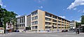 Frankfurt, Carl-Schurz-Schule.jpg 6,272 × 2,792; 14.07 MB
-
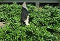 Gedenkstein-JvM.jpg 1,200 × 833; 641 KB
