Category:Capella de Sant Vicent Ferrer d'Onda
Jump to navigation
Jump to search
| Object location | | View all coordinates using: OpenStreetMap |
|---|
Onda  | |||||
| Upload media | |||||
| Instance of | |||||
|---|---|---|---|---|---|
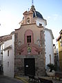
| Location | Onda, Plana Baixa, Castellón, Valencian Community, Spain | ||||
| Architectural style | |||||
| Heritage designation |
| ||||
| Width |
| ||||
| Length |
| ||||
| Elevation above sea level |
| ||||
 | |||||
Català: Capella de Sant Vicent Ferrer (Onda)
This is a category about a building listed in the Valencian heritage register as Bé de Rellevància Local (BRL) under the reference 12.06.084-009. |
Media in category "Capella de Sant Vicent Ferrer d'Onda"
The following 7 files are in this category, out of 7 total.
-
 48 Capella de Sant Vicent Ferrer.jpg 2,272 × 1,704; 895 KB
-
 Capella de sant Vicent, Onda.JPG 3,664 × 2,748; 1.21 MB
-
 Capella de Sant Vicent.jpg 1,536 × 2,048; 1.13 MB
-
 Carrer i capella de sant Vicent d'Onda.JPG 2,748 × 3,664; 1.75 MB
-
 Onda - 008 (30577156334).jpg 2,304 × 3,072; 2.08 MB
-
 Porta de la capella de sant Vicent Ferrer d'Onda.JPG 3,447 × 2,746; 1.68 MB
-
 San Vicente Ferrer. Onda.jpg 2,166 × 2,888; 4.8 MB


.jpg)

