Category:Cape Hangklip
Jump to navigation
Jump to search
English: Also Hanglip (i.e. hanging lip), or Caap Falso on old maps. Arriving from the east a navigator rounding the false cape would arrive in False Bay. Situated near Pringle Bay, and the location of Hangklip lighthouse, Q19623300. Not to be confused with Klein-Hangklip, 7 km to the north at Rooi-Els.
mountain and cape in Western Cape, South Africa; geonames ID = 3367058 | |||||
| Upload media | |||||
| Instance of | |||||
|---|---|---|---|---|---|
| Location |
| ||||
 | |||||
Subcategories
This category has the following 2 subcategories, out of 2 total.
F
- Flora of Cape Hangklip (57 F)
P
Media in category "Cape Hangklip"
The following 11 files are in this category, out of 11 total.
-
 Pringle Bay, Western Cape, South Africa, crop.jpg 1,968 × 646; 295 KB
-

-
 Cape of Good Hope Wellcome L0049847.jpg 5,981 × 3,764; 2.93 MB
-
 End Of The Continent (185052507).jpeg 2,048 × 1,367; 586 KB
-
 FalseBayCoast-aerial.jpg 3,648 × 2,736; 2.04 MB
-
 Pringle Bay, Western Cape, South Africa.JPG 2,500 × 1,875; 1.64 MB
-
 Pringle Bay.jpg 1,600 × 704; 306 KB
-
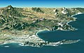 Satellite image of Cape peninsula.jpg 2,184 × 1,377; 1.46 MB
-
 Social Wikimania by Dyolf77 DSC 8852.jpg 4,634 × 3,076; 2.5 MB
-
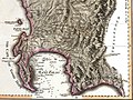 The Dutch Colony of the Cape of Good Hope by William Faden, 1795, crop.jpg 1,409 × 1,059; 881 KB
-
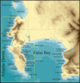 Topographical map Cape Peninsula and False Bay2.png 2,349 × 2,437; 557 KB
_(17800556533).jpg)

.jpeg)


