Category:Canton of La Châtre
Jump to navigation
Jump to search
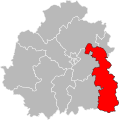
Français : Le canton de La Châtre est un canton français situé dans le département de l'Indre, en région Centre-Val de Loire. À la suite du redécoupage cantonal de 2014, les limites territoriales du canton sont remaniées. Le nombre de communes du canton passe de 19 à 34.
canton of France  | |||||
| Upload media | |||||
| Instance of | |||||
|---|---|---|---|---|---|
| Location | Indre, Centre-Val de Loire, Metropolitan France, France | ||||
| Capital |
| ||||
| Inception |
| ||||
| Population |
| ||||
| Area |
| ||||
 | |||||
Subcategories
This category has the following 34 subcategories, out of 34 total.
B
C
F
L
M
N
P
S
T
U
V
Media in category "Canton of La Châtre"
The following 3 files are in this category, out of 3 total.
-
 Carte du canton de La Châtre de 1790 à 2015.jpg 1,000 × 1,016; 161 KB
-
 Carte du canton de La Châtre à compter de 2015.jpg 1,000 × 1,016; 172 KB
-
 Indre - Canton La Châtre 2015.svg 651 × 658; 407 KB

