Category:California State Route 78
Jump to navigation
Jump to search
highway in California, USA   | |||||
| Upload media | |||||
| Instance of | |||||
|---|---|---|---|---|---|
| Location |
| ||||
| Transport network |
| ||||
| Owned by | |||||
| Maintained by | |||||
| Start time |
| ||||
| Inception |
| ||||
| Length |
| ||||
| Terminus | |||||
| |||||
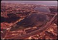
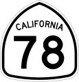
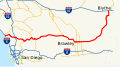
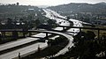
- California State Route 78 (SR 78) — a state highway traversing nearly the entire width of the state California, in Southern California.
- The route runs from Oceanside on the coast, eastward through the mountains and Colorado Desert to Blythe on the Colorado River.
- A section of the scenic road is part of the NPS Juan Bautista de Anza National Historic Trail.
Subcategories
This category has the following 3 subcategories, out of 3 total.
J
S
Media in category "California State Route 78"
The following 16 files are in this category, out of 16 total.
-
-
 CA 78 Anza-Borrego.jpg 3,868 × 2,132; 3.54 MB
-
 CA78histmap.jpg 1,035 × 621; 297 KB
-
 California 78 1957.svg 601 × 625; 26 KB
-
 California 78.svg 385 × 401; 13 KB
-
 California sr 78 1 camels.jpg 4,608 × 3,456; 8.66 MB
-
 California SR 78 east of Escondido.jpg 2,781 × 1,794; 1.93 MB
-
 California State Route 78 map.png 2,252 × 1,333; 76 KB
-
 California State Route 78 San Marcos.jpg 2,079 × 1,368; 976 KB
-
 California State Route 78.svg 1,152 × 640; 329 KB
-
 CASR78atS11 (cropped).jpg 1,920 × 1,080; 522 KB
-
 CASR78atS11.jpg 2,048 × 1,536; 689 KB
-
 CASR78Ramona.jpg 2,048 × 1,536; 791 KB
-
 Interstate 15 closure at SR 78 on 2010-12-09.jpg 4,248 × 2,388; 1.37 MB
-
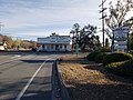 Santa Ysabel Store.jpg 4,032 × 3,024; 5.32 MB
-
 The Foundry Community Church(FMC).jpg 2,825 × 1,244; 786 KB


.jpg)


.jpg)