Category:Calder High School, Liverpool
Jump to navigation
Jump to search
| Object location | | View all coordinates using: OpenStreetMap |
|---|
building in Liverpool, Merseyside, UK  | |||||
| Upload media | |||||
| Instance of | |||||
|---|---|---|---|---|---|
| Location | Liverpool, Merseyside, North West England, England | ||||
| Heritage designation |
| ||||
 | |||||
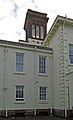
Grade II listed mid-19th century house, now part of Calderstones school.
Media in category "Calder High School, Liverpool"
The following 5 files are in this category, out of 5 total.
-
 Calder High School 1.jpg 4,925 × 3,554; 10.7 MB
-
 Calder High School 2.jpg 4,888 × 2,936; 6.53 MB
-
 Calder High School 3.jpg 2,720 × 4,472; 4.28 MB
-
 Calder High School 4.jpg 4,023 × 3,523; 5.78 MB
-
 Turret of Calder High School, Liverpool.jpg 4,096 × 2,896; 5.24 MB


