Category:Cairo Mississippi River Bridge
Jump to navigation
Jump to search
| Object location | | View all coordinates using: OpenStreetMap |
|---|
bridge in the United States  | |||||
| Upload media | |||||
| Instance of | |||||
|---|---|---|---|---|---|
| Location | |||||
| Crosses | |||||
| Inception |
| ||||
| Date of official opening |
| ||||
 | |||||
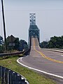
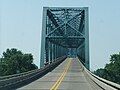
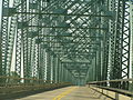
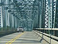
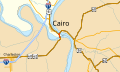
English: This road bridge carries U.S. Routes 60 and 62 over the Mississippi River just upstream from the Ohio River. The north end of this bridge is in Cairo, Alexander County, Illinois; the south end is in Mississippi County, Missouri, west of Bird's Point and northeast of Wyatt. Just north of this bridge is the Cairo Ohio River Bridge over the Ohio River.
Media in category "Cairo Mississippi River Bridge"
The following 24 files are in this category, out of 24 total.
-
 2018 Cairo Mississippi River Bridge.jpg 4,608 × 3,456; 3.43 MB
-
 Cairo IL Mississippi R Bridge P6190061.jpg 1,984 × 1,488; 620 KB
-
 Cairo illinois ohio river bridge.jpeg 640 × 480; 102 KB
-
 Cairo Mississippi River Bridge.jpg 1,818 × 1,228; 1.16 MB
-
 CairoMississippiBridge.jpg 800 × 536; 44 KB
-
 CairoMississippiRiverBridge.jpg 3,437 × 1,716; 2.57 MB
-
 Fort Defiance Park PA250457.JPG 3,072 × 2,304; 1.1 MB
-
 Mississippi River Bridge P6190064.JPG 1,488 × 1,984; 576 KB
-
 Mississippi River Bridge P6190065.JPG 1,984 × 1,488; 628 KB
-
 Mississippi River Bridge P6190066.JPG 1,984 × 1,488; 617 KB
-
 Mississippi River Bridge P6190070.JPG 1,984 × 1,488; 628 KB
-
 Mississippi River Bridge P6190071.JPG 1,984 × 1,488; 613 KB
-
 Mississippi River Bridge P6190081.JPG 1,984 × 1,488; 605 KB
-
 Mississippi River Bridge P6190082.JPG 1,984 × 1,488; 622 KB
-
 Mississippi River Bridge P6190083.JPG 1,984 × 1,488; 603 KB
-
 Mississippi River Bridge P6190084.JPG 1,984 × 1,488; 652 KB
-
 Mississippi River Bridge P6190085.JPG 1,984 × 1,488; 652 KB
-
 Mississippi River Bridge P6190086.JPG 1,984 × 1,488; 619 KB
-
 Mississippi River Bridge P6190087.JPG 1,984 × 1,488; 627 KB
-
 Mississippi River Bridge PA250449.JPG 2,304 × 3,072; 1.08 MB
-
 Mississippi River Bridge PA250450.JPG 2,304 × 3,072; 1.4 MB
-
 Mississippi River Bridge PA250456.JPG 3,072 × 2,304; 1.12 MB
-
 U.S. Route 60 Mississippi Co., MO (24506998486).jpg 5,472 × 3,078; 17.98 MB
-
 US 60-62 IL map.svg 1,026 × 608; 181 KB


.jpg)

Categories:
- Cairo, Illinois
- Mississippi County, Missouri
- Bridges over the Mississippi River in Illinois
- Bridges over the Mississippi River in Missouri
- Road bridges in Illinois
- Road bridges in Missouri
- Through truss bridges in Illinois
- Through truss bridges in Missouri
- 1920s bridges in Illinois
- 1920s bridges in Missouri
- Built in Illinois in 1929
- Built in Missouri in 1929
- Bridges in the United States completed in 1929
- Cantilever bridges in the United States
- Former toll bridges in the United States
- Bridges on U.S. Route 60
- Bridges on U.S. Route 62
- U.S. Route 60 in Illinois
- U.S. Route 62 in Illinois
- 1.5 kilometers bridges
- Bridges erected by American Bridge Company
- Bridges in Alexander County, Illinois