Category:CIA World Factbook maps of Bhutan
Jump to navigation
Jump to search
Media in category "CIA World Factbook maps of Bhutan"
The following 13 files are in this category, out of 13 total.
-
 2015 map detail, Bhutan Physiography (cropped).jpg 2,500 × 1,440; 699 KB
-
 Bhutan administrative divisions. LOC 2012586880.jpg 4,208 × 3,344; 1.4 MB
-
 Bhutan administrative divisions. LOC 2012586880.tif 4,208 × 3,344; 40.26 MB
-
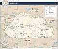
 Bhutan Administrative Divisions.jpg 2,608 × 2,215; 517 KB
-
 Bhutan CIA WFB 2010 map.png 326 × 350; 16 KB
-
 Bhutan map be.png 326 × 351; 14 KB
-
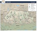 Bhutan Physiography.jpg 2,632 × 2,215; 948 KB
-
 Bhutan Transportation.jpg 2,608 × 2,214; 793 KB
-
 Bhutan – U.S. area comparison.jpg 701 × 851; 333 KB
-
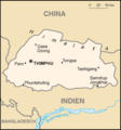 Bhutan.png 330 × 355; 9 KB
-
 Bt-map-ja.png 330 × 355; 23 KB
-
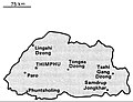
 World Factbook (1982) Bhutan.jpg 588 × 587; 105 KB
-
 World Factbook (1990) Bhutan.jpg 564 × 433; 66 KB
.jpg)


_Bhutan.jpg)
_Bhutan.jpg)