Category:Bureau of Land Management areas in Idaho
Jump to navigation
Jump to search
States of the United States: Alaska · Arizona · California · Colorado · Idaho · Montana · Nevada · New Mexico · Oregon · Utah · Washington · Wyoming
Wikimedia category | |||||
| Upload media | |||||
| Instance of | |||||
|---|---|---|---|---|---|
| |||||
English: BLM—Bureau of Land Management areas in Idaho.
- Semi-protected areas in the state, managed by the federal Bureau of Land Management—BLM agency.
Subcategories
This category has the following 11 subcategories, out of 11 total.
Media in category "Bureau of Land Management areas in Idaho"
The following 44 files are in this category, out of 44 total.
-
 Jimmy Smith Lake Landslide.JPG 2,816 × 2,112; 4.17 MB
-
 Astragalus mulfordiae habitat in SW Idaho.jpg 2,048 × 1,536; 668 KB
-
 Astragalus mulfordiae population with OHV tracks in SW Idaho.jpg 1,108 × 789; 106 KB
-
 Bassia prostrata doing well on playa edge in SW Idaho.jpg 1,024 × 768; 265 KB
-
 Battle Creek Idaho.jpg 265 × 204; 66 KB
-
 Battle Creek WSR (9433690048).jpg 2,592 × 1,944; 967 KB
-
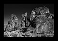 BW Hoodoos.jpg 1,150 × 819; 514 KB
-
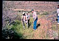 Carex aboriginum site and people in SW Idaho.jpg 1,119 × 784; 136 KB
-
 Cheatgrass and medusae head on BLM land in SW Idaho.jpg 2,272 × 1,704; 1.22 MB
-
 Cymopterus acaulis var. greeleyorum habitat in SW Idaho 3.jpg 1,024 × 768; 259 KB
-
 Downingia bacigalupii habitat in SW Idaho 3.jpg 2,048 × 1,536; 1.18 MB
-
 Eriogonum shockleyi var. packardiae in SW Idaho 2.jpg 2,272 × 1,704; 1.24 MB
-
 Eriogonum shockleyi var. packardiae in SW Idaho with road passing on top of.jpg 2,272 × 1,704; 1.2 MB
-
 Fenceline through Lepidium davisii playa in SW Idaho.jpg 2,272 × 1,704; 1.27 MB
-
 Hells Half Acre.jpg 800 × 492; 55 KB
-
 Ipomopsis polycladon habitat in SW Idaho.jpg 1,108 × 738; 104 KB
-
 Jimmy Smith Lake Idaho.JPG 986 × 739; 283 KB
-
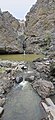
 Jump Creek Falls 1.jpg 1,000 × 664; 506 KB
-
 Jump Creek Falls 2.jpg 664 × 1,000; 567 KB
-
 Kali tragus buildup on playa that has rare plants in SW Idaho.jpg 1,024 × 768; 214 KB
-
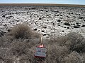 Lepidium davisii long term monitoring on playa in SW Idaho 3.jpg 1,024 × 768; 270 KB
-
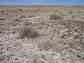
 Lepidium davisii playa habitat in SW Idaho.jpg 1,024 × 768; 208 KB
-
 Lepidium davisii playa with tire tracks in SW Idaho.jpg 2,272 × 1,704; 1.2 MB
-
 Lepidium papilliferum flowering in SW Idaho 7.jpg 2,272 × 1,704; 1.27 MB
-
 Little City of Rocks Idaho.JPG 3,648 × 2,736; 6.04 MB
-
 Little City of Rocks.JPG 3,648 × 2,736; 5.71 MB
-
 Mentzelia mollis population with heavy cattle trampling in SW Idaho.jpg 1,119 × 789; 89 KB
-
 My Public Lands Roadtrip- BLM Idaho (18596070966).jpg 1,201 × 800; 957 KB
-
 My Public Lands Roadtrip- Little City of Rocks in Idaho (18613441070).jpg 2,592 × 1,944; 1.33 MB
-
 My Public Lands Roadtrip- Little City of Rocks in Idaho (18803754451).jpg 2,304 × 3,072; 4.41 MB
-
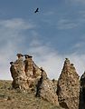
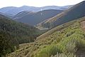
 My Public Lands Summer Road Trip- Tower Creek Pyramids in Idaho (18668874295).jpg 1,798 × 1,169; 816 KB
-
 My Public Lands Summer Road Trip- Tower Creek Pyramids in Idaho (18668874695).jpg 2,132 × 2,721; 1.1 MB
-
 My Public Lands Summer Road Trip- Tower Creek Pyramids in Idaho (18668875145).jpg 3,072 × 2,048; 1.5 MB
-
 My Public Lands Summer Road Trip- Tower Creek Pyramids in Idaho (18671156991).jpg 3,072 × 1,578; 1.12 MB
-
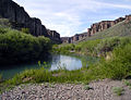
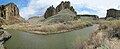
 Owyhee River Wilderness A.jpg 600 × 274; 40 KB
-
 Owyhee River Wilderness B.jpg 600 × 244; 30 KB
-
 Owyhee River Wilderness C.jpg 207 × 450; 26 KB
-
 Owyhee River Wilderness.jpg 150 × 132; 6 KB
-
 Pockets of sagebrush in drainages understory dominated by non-native annuals in SW Idaho.jpg 2,272 × 1,704; 1.24 MB
-
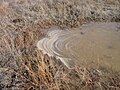 Polluted water in mini playa from cattle in SW Idaho.jpg 1,024 × 768; 243 KB
-
 Pyrrocoma radiata habitat in December in SW Idaho.jpg 1,154 × 750; 84 KB
-
 Rasmussen Valley Mine, Caribou County, Idaho - final environmental impact statement (IA rasmussenvalleym01unse).pdf 1,293 × 1,645, 818 pages; 146.2 MB
-
 Seeded playa which is habitat for rare plants in SW Idaho.jpg 1,024 × 768; 252 KB
-
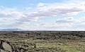
 Snake River Plain Idaho.jpg 2,272 × 1,704; 1.27 MB


.jpg)


.jpg)
.jpg)
.jpg)
.jpg)
.jpg)
.jpg)
.jpg)


