Category:Bull Lane bridge, Orrell Park
Jump to navigation
Jump to search
| Object location | | View all coordinates using: OpenStreetMap |
|---|

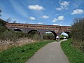
This bridge carried Bull Lane over the North Liverpool Extension Line, which sat in a wide valley at this location. At this bridge Bull Lane ran northwards parallel to what is now the Northern Line of Merseyrail, crossing the line at what is now Helsby Road bridge and continuing into Church Avenue. Today, however, Bull Lane comes to an abrupt halt at the railway line.
Media in category "Bull Lane bridge, Orrell Park"
The following 10 files are in this category, out of 10 total.
-
 Bull Lane Bridge - geograph.org.uk - 1293101.jpg 640 × 480; 77 KB
-
 Bull Lane bridge 1.jpg 5,152 × 3,864; 6.96 MB
-
 Bull Lane bridge 2.jpg 5,152 × 3,864; 7.47 MB
-
 Bull Lane bridge 3.jpg 5,152 × 3,864; 6.86 MB
-
 Bull Lane bridge 4.jpg 5,152 × 3,864; 7.35 MB
-
 Bull Lane bridge 5.jpg 5,152 × 3,864; 7.42 MB
-
 Bull Lane bridge 6.jpg 5,152 × 3,864; 7.61 MB
-
 Bull Lane Bridge crosses NLER.jpg 1,984 × 1,488; 634 KB
-
 View north from Bull Lane bridge.jpg 5,152 × 3,864; 7.58 MB
-
 View south from Bull Lane bridge.jpg 5,152 × 3,864; 7.5 MB


