Category:Brugstraat 1, Grave
Jump to navigation
Jump to search
| Object location | | View all coordinates using: OpenStreetMap |
|---|
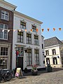
house in Grave, Netherlands  | |||||
| Upload media | |||||
| Instance of | |||||
|---|---|---|---|---|---|
| Location | Grave, Land van Cuijk, North Brabant, Netherlands | ||||
| Street address |
| ||||
| Located on street | |||||
| Heritage designation |
| ||||
 | |||||
|
This is a category about rijksmonument number 17213
|
| Address |
|
Media in category "Brugstraat 1, Grave"
The following 6 files are in this category, out of 6 total.
-
 Grave - Brugstraat 1.jpg 1,944 × 2,592; 1.22 MB
-
 Ingangspartij - Grave - 20084015 - RCE.jpg 930 × 1,200; 212 KB
-
 Kamerdeur - Grave - 20084018 - RCE.jpg 953 × 1,200; 147 KB
-
 Overzicht - Grave - 20084021 - RCE.jpg 1,200 × 955; 249 KB
-
 Trapleuning - Grave - 20084016 - RCE.jpg 1,200 × 956; 150 KB
-
 Trappaal - Grave - 20084019 - RCE.jpg 959 × 1,200; 146 KB


