Category:Bruern
Jump to navigation
Jump to search
civil parish in West Oxfordshire, Oxfordshire, England  | |||||
| Upload media | |||||
| Instance of | |||||
|---|---|---|---|---|---|
| Location | West Oxfordshire, Oxfordshire, South East England, England | ||||
| Inception |
| ||||
 | |||||
Media in category "Bruern"
The following 114 files are in this category, out of 114 total.
-

-

-
 A424 at Habber Gallows Hill - geograph.org.uk - 2651743.jpg 640 × 480; 61 KB
-
 Across the harvested field - geograph.org.uk - 4223090.jpg 4,320 × 3,240; 5.08 MB
-
 Alongside the copse - geograph.org.uk - 2400224.jpg 4,288 × 3,216; 3.12 MB
-
 Barn at Tangley Farm - geograph.org.uk - 3206502.jpg 640 × 427; 238 KB
-
 Bend in the road - geograph.org.uk - 1232032.jpg 640 × 427; 82 KB
-
 Bend in the track - geograph.org.uk - 2400409.jpg 4,288 × 3,216; 3.91 MB
-
 Bend in the track - geograph.org.uk - 4223735.jpg 4,320 × 3,240; 4.86 MB
-
 Bend in the track - geograph.org.uk - 4223782.jpg 4,320 × 3,240; 5.09 MB
-
 Between hedges - geograph.org.uk - 4223758.jpg 4,320 × 3,240; 5.25 MB
-
 Beware gentle animals - geograph.org.uk - 4223745.jpg 4,320 × 3,240; 4.67 MB
-
 Beware of fierce animals - geograph.org.uk - 4223740.jpg 4,320 × 3,240; 4.97 MB
-
 Bluebells in the copse - geograph.org.uk - 2400230.jpg 4,288 × 3,216; 7.29 MB
-
 Bridleway at Choake's Barn - geograph.org.uk - 3201852.jpg 640 × 427; 197 KB
-
 Bridleway crosses road (1) - geograph.org.uk - 2398624.jpg 4,288 × 3,216; 2.5 MB
-
 Bridleway crosses road (2) - geograph.org.uk - 2400223.jpg 4,288 × 3,216; 5.31 MB
-
 Bridleway crosses road - geograph.org.uk - 4223685.jpg 4,320 × 3,240; 5.01 MB
-
 Bridleway in the woods - geograph.org.uk - 4223729.jpg 4,320 × 3,240; 5.12 MB
-
 Bridleway meets road - geograph.org.uk - 2397091.jpg 4,288 × 3,216; 2.3 MB
-

-

-
 Bridleway towards Tangley Farm - geograph.org.uk - 3206480.jpg 640 × 427; 207 KB
-
 Crossing cottage - geograph.org.uk - 1232288.jpg 640 × 427; 70 KB
-
 Bruern Abbey (1) - geograph.org.uk - 2398603.jpg 4,288 × 3,216; 4.74 MB
-
 Bruern Abbey (2) - geograph.org.uk - 2398612.jpg 4,288 × 3,216; 3.27 MB
-
 Bruern Abbey avenue - geograph.org.uk - 2398618.jpg 4,288 × 3,216; 2.68 MB
-
 Bruern Grange (1) - geograph.org.uk - 2397114.jpg 4,288 × 3,216; 3.67 MB
-
 Bruern Grange (2) - geograph.org.uk - 2397122.jpg 4,288 × 3,216; 3.43 MB
-
 Bruern Grange (3) - geograph.org.uk - 2397126.jpg 4,288 × 3,216; 6.11 MB
-
 Bruern Grange farmhouse - geograph.org.uk - 1232021.jpg 640 × 427; 62 KB
-
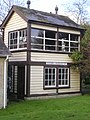 Bruern Railway Crossing Signal Box - geograph.org.uk - 1671392.jpg 1,536 × 2,048; 645 KB
-
 Cattle grid on bridleway - geograph.org.uk - 2400676.jpg 3,629 × 3,163; 2.54 MB
-
 Change of use coming^ - geograph.org.uk - 4222370.jpg 4,320 × 3,240; 4.96 MB
-
 Choose the way (1) - geograph.org.uk - 2400394.jpg 4,288 × 3,216; 4.05 MB
-
 Choose the way (2) - geograph.org.uk - 2400404.jpg 4,288 × 3,216; 1.9 MB
-
 Converted barn - geograph.org.uk - 2402268.jpg 4,288 × 3,216; 1.14 MB
-
 Cottage at Coombe Brook - geograph.org.uk - 3206492.jpg 640 × 466; 262 KB
-
 Country crossroads - geograph.org.uk - 4222392.jpg 4,320 × 3,240; 4.63 MB
-
 Crossroads on the A424 - geograph.org.uk - 4223124.jpg 4,320 × 3,240; 4.98 MB
-
 Double bend - geograph.org.uk - 4223791.jpg 4,320 × 3,240; 4.99 MB
-
 Farmland at Barrett's Brake - geograph.org.uk - 3206519.jpg 640 × 428; 257 KB
-
 Field edge track - geograph.org.uk - 4223784.jpg 4,320 × 3,240; 4.92 MB
-
 Fields of grain - geograph.org.uk - 4222397.jpg 4,320 × 3,240; 4.39 MB
-
 Footpath from Tangley Farm - geograph.org.uk - 3206516.jpg 640 × 427; 200 KB
-
 Footpath towards A424 - geograph.org.uk - 3206527.jpg 640 × 427; 241 KB
-
 Footpath towards Fifield - geograph.org.uk - 3206525.jpg 640 × 427; 204 KB
-
 Grange Farm - geograph.org.uk - 2397102.jpg 4,288 × 3,216; 1.69 MB
-
 Grange Farm Cottages - geograph.org.uk - 2397100.jpg 4,288 × 3,216; 3.01 MB
-
 Grange Farm Cottages - geograph.org.uk - 2679354.jpg 640 × 480; 51 KB
-
 Grange Farm, Bruern - geograph.org.uk - 1232043.jpg 640 × 427; 46 KB
-
 Ground-level fungi - geograph.org.uk - 2400437.jpg 4,288 × 3,216; 7.06 MB
-
 Hidden stile (1) - geograph.org.uk - 4223094.jpg 3,240 × 4,320; 4.62 MB
-
 Hidden stile (2) - geograph.org.uk - 4223102.jpg 3,240 × 4,320; 4.51 MB
-
 Hill Farm Barn - geograph.org.uk - 1216049.jpg 640 × 427; 45 KB
-
 Hill Farmhouse - geograph.org.uk - 4222358.jpg 4,320 × 3,240; 4.88 MB
-
 Home Farm (1) - geograph.org.uk - 2402258.jpg 4,288 × 3,216; 2.46 MB
-
 Home Farm - geograph.org.uk - 1232116.jpg 640 × 427; 52 KB
-
 Houses beside the road - geograph.org.uk - 1232080.jpg 640 × 427; 62 KB
-
 In Bruern Wood (1) - geograph.org.uk - 2398571.jpg 4,288 × 3,216; 2.99 MB
-
 In Bruern Wood (2) - geograph.org.uk - 2398595.jpg 4,288 × 3,216; 5.09 MB
-
 Into the valley bottom - geograph.org.uk - 4223769.jpg 4,320 × 3,240; 4.82 MB
-
 Junction on the A424 - geograph.org.uk - 6304528.jpg 1,920 × 1,280; 1.38 MB
-
 Large barn - geograph.org.uk - 2402272.jpg 4,288 × 3,216; 2.3 MB
-
 Large fungus - geograph.org.uk - 4223761.jpg 4,320 × 3,240; 4.75 MB
-
 Listed barn - geograph.org.uk - 4222362.jpg 4,320 × 3,240; 4.9 MB
-
 Looking back along the road - geograph.org.uk - 1232138.jpg 640 × 427; 40 KB
-
 Mobile water supply - geograph.org.uk - 4223757.jpg 4,320 × 3,240; 4.73 MB
-
 On Habber Gallows Hill - geograph.org.uk - 2433590.jpg 1,024 × 680; 192 KB
-
 Over the stream - geograph.org.uk - 2397129.jpg 4,288 × 3,216; 3.52 MB
-
 Oxfordshire countryside - geograph.org.uk - 4223775.jpg 4,320 × 3,240; 4.74 MB
-
 Path leaves road - geograph.org.uk - 2397096.jpg 4,288 × 3,216; 2.22 MB
-
 Path meets bridleway - geograph.org.uk - 2395790.jpg 4,288 × 3,216; 1.56 MB
-
 Path meets road - geograph.org.uk - 4223120.jpg 4,320 × 3,240; 5.32 MB
-
 Plovers Cottage - geograph.org.uk - 4222347.jpg 4,320 × 3,240; 5.04 MB
-
 Public footpath and bridleway - geograph.org.uk - 1232057.jpg 640 × 427; 99 KB
-
 Rear view - geograph.org.uk - 4222382.jpg 4,320 × 3,240; 4.77 MB
-
 Resting machinery - geograph.org.uk - 4223108.jpg 4,320 × 3,240; 4.84 MB
-
 Road from Bruern - geograph.org.uk - 1241882.jpg 640 × 480; 38 KB
-
 Road to Tangley Hall - geograph.org.uk - 1513430.jpg 640 × 427; 54 KB
-
 Roadside cottage - geograph.org.uk - 1232094.jpg 640 × 427; 86 KB
-
 Seven Shires Way - geograph.org.uk - 2679331.jpg 640 × 480; 121 KB
-
 Seven Shires Way - geograph.org.uk - 2679340.jpg 640 × 480; 104 KB
-
 Seven Shires Way - geograph.org.uk - 2679345.jpg 640 × 480; 57 KB
-
 Shooting platforms - geograph.org.uk - 3206496.jpg 640 × 427; 188 KB
-
 Staggered crossroads - geograph.org.uk - 1092047.jpg 640 × 480; 41 KB
-
 Tangley Farm (1) - geograph.org.uk - 4223704.jpg 4,320 × 3,240; 5.06 MB
-
 Tangley Farm (2) - geograph.org.uk - 4223722.jpg 4,320 × 3,240; 4.95 MB
-
 Tangley Farmhouse - geograph.org.uk - 4223707.jpg 4,320 × 3,240; 5.02 MB
-
 Tangley Hall (1) - geograph.org.uk - 4223151.jpg 4,320 × 3,240; 4.92 MB
-
 Tangley Hall (2) - geograph.org.uk - 4223154.jpg 4,320 × 3,240; 5.03 MB
-
 Tangley Hall Farm - geograph.org.uk - 3206506.jpg 640 × 427; 212 KB
-
 The A424 near Milton-under-Wychwood - geograph.org.uk - 6268970.jpg 1,920 × 1,280; 1.32 MB
-
 The A424 near Milton-under-Wychwood - geograph.org.uk - 6304529.jpg 1,814 × 1,182; 1.49 MB
-
 The McKenzie Institute - geograph.org.uk - 1216090.jpg 640 × 427; 68 KB
-
 The Way and the abbey - geograph.org.uk - 2398600.jpg 4,288 × 3,216; 5.88 MB
-
 The way divides - geograph.org.uk - 4223715.jpg 4,320 × 3,240; 4.77 MB
-
 Through the crop - geograph.org.uk - 2397086.jpg 4,288 × 3,216; 1.85 MB
-
 Through the hedge - geograph.org.uk - 4223765.jpg 4,320 × 3,240; 5.19 MB
-
 Towards Choake's Barn - geograph.org.uk - 3201851.jpg 640 × 427; 197 KB
-
 Towards Choake's Barn - geograph.org.uk - 3201856.jpg 640 × 427; 172 KB
-
 Towards Little Rissington airfield - geograph.org.uk - 3201840.jpg 640 × 427; 183 KB
-
 Towards Tangley Farm - geograph.org.uk - 3206514.jpg 640 × 427; 203 KB
-
 Towards the road - geograph.org.uk - 4223118.jpg 4,320 × 3,240; 5.04 MB
-
 Track to the farm - geograph.org.uk - 2400698.jpg 4,288 × 3,216; 6.16 MB
-
 Track to the road - geograph.org.uk - 2400427.jpg 4,288 × 3,216; 2.7 MB
-
 Track to the woodland - geograph.org.uk - 4223768.jpg 4,320 × 3,240; 4.85 MB
-
 Tree lined road to Bruern - geograph.org.uk - 1232070.jpg 640 × 427; 84 KB
-
 Turning to Milton and Shipton - geograph.org.uk - 1232152.jpg 640 × 427; 51 KB
-
 Two ways to go - geograph.org.uk - 2397107.jpg 4,288 × 3,216; 2.19 MB
-
 Upland vista on the A424 - geograph.org.uk - 2651785.jpg 640 × 480; 50 KB
-
 Valley bottom - geograph.org.uk - 4223772.jpg 4,320 × 3,240; 5.09 MB
-
 Well House at Tangley Hall - geograph.org.uk - 4223683.jpg 4,320 × 3,240; 4.68 MB
-
 A424 towards Stow On the Wold - geograph.org.uk - 1071830.jpg 640 × 427; 57 KB


_-_geograph.org.uk_-_2398624.jpg)
_-_geograph.org.uk_-_2400223.jpg)


_-_geograph.org.uk_-_2398603.jpg)
_-_geograph.org.uk_-_2398612.jpg)

_-_geograph.org.uk_-_2397114.jpg)
_-_geograph.org.uk_-_2397122.jpg)
_-_geograph.org.uk_-_2397126.jpg)


_-_geograph.org.uk_-_2400394.jpg)
_-_geograph.org.uk_-_2400404.jpg)


_-_geograph.org.uk_-_4223094.jpg)
_-_geograph.org.uk_-_4223102.jpg)


_-_geograph.org.uk_-_2402258.jpg)


_-_geograph.org.uk_-_2398571.jpg)
_-_geograph.org.uk_-_2398595.jpg)


_-_geograph.org.uk_-_4223704.jpg)
_-_geograph.org.uk_-_4223722.jpg)

_-_geograph.org.uk_-_4223151.jpg)
_-_geograph.org.uk_-_4223154.jpg)


