Help
Category
:
Broughton Flume
From Wikimedia Commons, the free media repository
Jump to navigation
Jump to search
Media in category "Broughton Flume"
The following 30 files are in this category, out of 30 total.
At city park rest area, state Highway 14. Section of steel flume once spanning highway (original location unknown). North-northwest 350 degrees. - Broughton Flume, Hood River Junction HAER WA-170-10.tif
3,681 × 5,209; 18.29 MB
At city park rest area. Section of steel flume once spanning highway (original location unknown). Note large tree segment at rear left. South-southwest 240 degrees. - Broughton Flume, HAER WA-170-11.tif
5,147 × 3,712; 18.22 MB
At Drano Lake boat ramp and flume historical marker on state Highway 14. Mountain cut to left, flume in middle, tunnels (highway and BNSF RR) to right. North-northeast 20 degrees. - HAER WA-170-8.tif
5,174 × 3,660; 18.06 MB
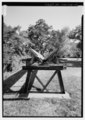
At Morby's property, end of Chenoweth Road. Detail of typical flume and supporting framework. North-northwest 310 degrees. - Broughton Flume, Hood River Junction on Columbia River at HAER WA-170-15.tif
5,147 × 3,690; 18.12 MB
At Morby's property, end of Chenoweth Road. General view of flume. Northwest view. - Broughton Flume, Hood River Junction on Columbia River at Washington-Oregon border, Hood, Skamania HAER WA-170-18.tif
5,165 × 3,677; 18.11 MB
At Morby's property, end of Chenoweth Road. North of road, view of flume section. Northwest view. - Broughton Flume, Hood River Junction on Columbia River at Washington-Oregon border, HAER WA-170-16.tif
5,169 × 3,681; 18.15 MB
At Morby's property, end of Chenoweth Road. Silvered cedar flume section, trough detail with flowers growing out of trough. Southwest view. - Broughton Flume, Hood River Junction on HAER WA-170-17.tif
5,177 × 3,703; 18.29 MB
At Morby's property, end of Chenoweth Road. South of road, same as WA-170-12. View looking down length of flume. Note walkways on both sides of flume, hut, platforms on both sides of HAER WA-170-13.tif
3,690 × 5,195; 18.28 MB
At Morby's property, end of Chenoweth Road. South of road, same as WA-170-13 but looking north. Photographer standing on platform, shed on right, water release gate on right. North HAER WA-170-12.tif
5,147 × 3,664; 17.99 MB
At Morby's property, end of Chenoweth Road. South of road. Shed with cable on right used to trip second water release gate on flume (in foreground). Bridge across flume, emergency cable HAER WA-170-14.tif
5,174 × 3,668; 18.1 MB
At tunnel lake on state Highway 14. Section of steel flume once spanning highway (original location unknown). North-northwest 350 degrees. - Broughton Flume, Hood River Junction on HAER WA-170-9.tif
5,147 × 3,690; 18.12 MB
At Willard, corner of Willard Road and Cook Underwood Road. Metal flume section (once located elsewhere, over another road). Note skewed section. North-northeast 20 degrees. - Broughton HAER WA-170-20.tif
5,160 × 3,690; 18.16 MB
At Willard, corner of Willard Road and Oklahoma Road. Metal flume section (once located elsewhere, over another road). Note skewed section. North-northeast 80 degrees. - Broughton Flume HAER WA-170-19.tif
5,160 × 3,699; 18.21 MB
At Willard, corner of Willard Road and Oklahoma Road. Metal flume section (once located elsewhere, over another road). Note skewed section. South-southwest 260 degrees. - Broughton HAER WA-170-25.tif
5,143 × 3,690; 18.1 MB
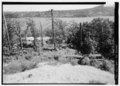
At Willard, Little Salmon Creek. Site of former dam and water supply pond for Broughton flume. Bridge over intake trough, gate in background behind bridge. South 170 degrees. - HAER WA-170-28.tif
5,161 × 3,660; 18.02 MB
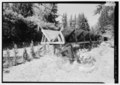
At Willard, Little Salmon Creek. Site of former dam and water supply pond for Broughton flume. Gate, wind walls, covered trough, bridge in background. North-northwest 330 degrees. - HAER WA-170-31.tif
3,711 × 5,221; 18.48 MB
At Willard, Little Salmon Creek. Site of former dam and water supply pond for Broughton flume. Remains of dam structures on right and left banks. North-northeast 80 degrees. - Broughton HAER WA-170-26.tif
5,152 × 3,668; 18.02 MB
At Willard, Little Salmon Creek. Site of former dam and water supply pond for Broughton flume. View from downstream of intake, dam wind wall to right, lower wall of overflow chute in HAER WA-170-29.tif
5,161 × 3,678; 18.11 MB
At Willard, Little Salmon Creek. Site of former dam and water supply pond for Broughton flume. View from flume (Photographer standing in flume). Note wide flume mouth, covered trough, HAER WA-170-33.tif
5,161 × 3,664; 18.04 MB
At Willard, Little Salmon Creek. Site of former dam and water supply pond for Broughton flume. View looking down flume at transition from covered trough to flume (covered trough is HAER WA-170-32.tif
3,711 × 5,193; 18.38 MB
At Willard, Little Salmon Creek. Site of former dam and water supply pond for Broughton flume. View of dam structures - wing walls, overflow shute to right, camera in middle of flume HAER WA-170-27.tif
4,964 × 3,712; 17.58 MB
At Willard, Little Salmon Creek. Site of former dam and water supply pond for Broughton flume. View through gate, covered trough on other side of gate leading to flume in distance. HAER WA-170-30.tif
5,170 × 3,669; 18.09 MB
At Willard, Oklahoma Road north of Willard Road, at the site of the former Cook House for Willard Mill (upper mill that cut cants for Broughton Lumber Company's flume). Section of HAER WA-170-34.tif
3,711 × 5,207; 18.43 MB
At Willard, Oklahoma Road north of Willard Road, at the site of the former Cook House for Willard Mill (upper mill that cut cants for Broughton Lumber Company's flume). View of end HAER WA-170-35.tif
3,711 × 5,184; 18.35 MB
Flume midway up mountain, close view (480 lens). North 0 degrees. - Broughton Flume, Hood River Junction on Columbia River at Washington-Oregon border, Hood, Skamania County, WA HAER WA-170-7.tif
5,156 × 3,686; 18.13 MB
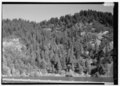
Flume midway up mountain. North 0 degrees - Broughton Flume, Hood River Junction on Columbia River at Washington-Oregon border, Hood, Skamania County, WA HAER WA-170-6.tif
5,156 × 3,664; 18.02 MB
From hilltop, Route 14, last segment of flume before Broughton Lumber Company. Section of flume and broken out section. Columbia River and Oregon in background. West-southwest 240 HAER WA-170-38.tif
5,120 × 3,678; 17.96 MB
From hilltop, Route 14, last segment of flume before Broughton Lumber Company. Section of flume, BNSF tracks, Highway 14 and Columbia River. South-southwest 220 degrees. - Broughton HAER WA-170-39.tif
5,189 × 3,692; 18.27 MB
From hilltop, Route 14, last segment of flume before Broughton Lumber Company. Section of flume, looking toward Columbia River, mount hood. South 0 degrees. - Broughton Flume, Hood HAER WA-170-37.tif
3,702 × 5,198; 18.35 MB
From hilltop, Route 14, last segment of flume before Broughton Lumber Company. Section of flume, looking toward Columbia River, mount hood. South-southeast 160 degrees. - Broughton HAER WA-170-36.tif
5,142 × 3,683; 18.06 MB
Categories
:
Broughton Lumber Company
Flumes in the United States
Navigation menu
Personal tools
English
Not logged in
Talk
Contributions
Create account
Log in
Namespaces
Category
Discussion
English
Views
View
Edit
History
More
Search
Navigate
Main page
Welcome
Community portal
Village pump
Help center
Participate
Upload file
Recent changes
Latest files
Random file
Contact us
Tools
What links here
Related changes
Special pages
Permanent link
Page information
Get shortened URL
Download QR code
Print/export
Create a book
Download as PDF
Printable version
In Wikipedia
Add links