Category:Bromley maps of Staten Island published in 1917
Jump to navigation
Jump to search
Maps from:
- Bromley, George W. and Walter S. Atlas of the City of New York Borough of Richmond Staten Island. Volume One: Wards 1, 2 & 3. (Philadelphia: G. W. Bromley and Co., 1917), comprising title page, street index, and double-page volume index, plus 44 maps (double-page plates); and
- Bromley, George W. and Walter S. Atlas of the City of New York Borough of Richmond Staten Island. Volume Two: Wards 4 & 5. (Philadelphia: G. W. Bromley and Co., 1917), comprising title page, street index, and double-page volume index, plus 44 maps (double-page plates).
Missing from this category: Vol. 1: Plates No. 24 (image ID: 1646244), 25 (1646245), and 34 (1646254); Vol. 2: Plates No. 23–26 (1646290–3).
Online at The New York Public Library Digital Collections website, Volume One: Wards 1, 2, & 3 and Volume Two: Wards 4 & 5.
Media in category "Bromley maps of Staten Island published in 1917"
The following 86 files are in this category, out of 86 total.
-

-

-

-

-

-

-
-

-

-

-

-

-

-

-

-

-

-

-

-

-
-

-

-

-

-

-

-

-
-
-

-

-

-

-
-

-

-

-

-

-

-

-

-

-

-

-

-

-

-

-

-

-

-
-

-

-

-

-

-

-

-
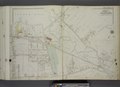
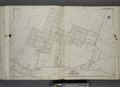
 Part of Ward 4. (Map bound by Steuben St, Mosel Ave, Clove Ave, Richmond Road) NYPL1646273.tiff 7,230 × 5,228; 108.14 MB
-

-

-

-

-

-

-

-
-

-

-
-

-
-

-

-

-

-

-

-

-

-

-
 Street Index.; Street Index of Obsolete Names. NYPL1646266.tiff 5,428 × 6,842; 106.26 MB
-
 Street Index.; Street Index of Obsolete Names. NYPL1646316.tiff 5,428 × 6,842; 106.26 MB