Category:Broadgreen intersection bridge
Jump to navigation
Jump to search
| Object location | | View all coordinates using: OpenStreetMap |
|---|
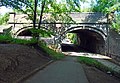
This bridge carries the City Line of Merseyrail east from Broadgreen station over the former North Liverpool Extension Line, and has the identifier DSE/43. It is 3.70 miles from Lime Street.
Media in category "Broadgreen intersection bridge"
The following 5 files are in this category, out of 5 total.
-
 Broadgreen intersection bridge 1.jpg 4,836 × 3,360; 9.51 MB
-
 Broadgreen intersection bridge 2.jpg 4,626 × 3,240; 7.86 MB
-
 Broadgreen intersection bridge 3.jpg 4,470 × 3,018; 8.32 MB
-
 Broadgreen intersection bridge 4.jpg 4,974 × 3,718; 10.17 MB
-
 Broadgreen intersection bridge 5.jpg 5,152 × 3,864; 9.2 MB


