Category:Broad Campden
Jump to navigation
Jump to search
village in United Kingdom  | |||||
| Upload media | |||||
| Instance of | |||||
|---|---|---|---|---|---|
| Location | Chipping Campden, Cotswold, Gloucestershire, South West England, England | ||||
 | |||||
Subcategories
This category has only the following subcategory.
Media in category "Broad Campden"
The following 52 files are in this category, out of 52 total.
-
-
 Broad Campden - geograph.org.uk - 246344.jpg 640 × 480; 80 KB
-
 Broad Campden - geograph.org.uk - 34764.jpg 640 × 480; 136 KB
-
 Broad Campden - geograph.org.uk - 557594.jpg 640 × 428; 109 KB
-
 Broad Campden - geograph.org.uk - 557643.jpg 640 × 428; 125 KB
-
 Broad Campden, Gloucestershire-geograph-1682627-by-Michael-Dibb.jpg 4,000 × 3,000; 2.69 MB
-
 Campden Hill Farm - geograph.org.uk - 1587371.jpg 640 × 480; 96 KB
-
 Campden Hill Farm - geograph.org.uk - 890953.jpg 640 × 426; 116 KB
-
 Chipping Campden Fire Station - geograph.org.uk - 233891.jpg 640 × 480; 71 KB
-
 Chipping from Broad - geograph.org.uk - 561522.jpg 640 × 480; 77 KB
-
 Church fields near Chipping Camden - geograph.org.uk - 718861.jpg 640 × 480; 119 KB
-
 Farm buildings, Campden Hill Farm - geograph.org.uk - 890955.jpg 640 × 426; 106 KB
-
 Field of peas - geograph.org.uk - 235215.jpg 640 × 480; 126 KB
-
 Five Mile Drive - geograph.org.uk - 1587339.jpg 640 × 480; 147 KB
-
 Footpath by the cottage, Broad Campden-geograph-1951037-by-Michael-Dibb.jpg 4,000 × 3,000; 3.6 MB
-
 Hill Barn, near Broad Campden - geograph.org.uk - 893345.jpg 640 × 426; 116 KB
-
 Horse beside the Heart of England Way - geograph.org.uk - 894418.jpg 640 × 426; 73 KB
-
 House in Broad Campden-geograph-1951039-by-Michael-Dibb.jpg 4,000 × 3,000; 3.52 MB
-
 Houses in Broad Campden - geograph.org.uk - 893363.jpg 640 × 426; 68 KB
-
 I can see you... - geograph.org.uk - 893273.jpg 640 × 426; 120 KB
-
 In Five Mile Drive - geograph.org.uk - 1587718.jpg 640 × 480; 149 KB
-
 Into the village of Broad Campden, Gloucestershire-geograph-1681857-by-Michael-Dibb.jpg 4,000 × 3,000; 2.33 MB
-
 Lane, Broad Campden-3259024698.jpg 1,728 × 2,304; 1.35 MB
-
 Lapstone Farm - geograph.org.uk - 1587712.jpg 640 × 480; 77 KB
-
 Norman Chapel House Broad Campden dated 1895.jpg 354 × 450; 45 KB
-
 Out of the woods - geograph.org.uk - 1587723.jpg 640 × 480; 112 KB
-
 Overgrown hedge - geograph.org.uk - 235185.jpg 640 × 480; 111 KB
-
 Parting of the ways - geograph.org.uk - 1587393.jpg 640 × 480; 136 KB
-
 Ploughed and harrowed field - geograph.org.uk - 235180.jpg 640 × 480; 100 KB
-
 Quaker Meeting House, Broad Campden.jpg 3,853 × 2,753; 6.62 MB
-
 Quarry plant - geograph.org.uk - 236415.jpg 640 × 480; 124 KB
-
 Quarry workings - geograph.org.uk - 1587356.jpg 640 × 480; 76 KB
-
 Ripening barley - geograph.org.uk - 890951.jpg 640 × 426; 104 KB
-
 Sedgecombe - geograph.org.uk - 374523.jpg 640 × 480; 72 KB
-
 Sunset apples - geograph.org.uk - 235221.jpg 640 × 480; 146 KB
-
 Thatch in Broad Campden - geograph.org.uk - 1949331.jpg 4,000 × 3,000; 2.9 MB
-
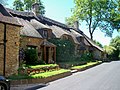
 Thatched cottage in Broad Campden - geograph.org.uk - 893401.jpg 640 × 426; 65 KB
-
 Thatched Cottage, Broad Campden - geograph.org.uk - 36111.jpg 640 × 480; 113 KB
-
 The Baker's Arms, Broad Campden - geograph.org.uk - 36092.jpg 640 × 480; 137 KB
-
 The Heart of England Way, Broad Campden - geograph.org.uk - 893416.jpg 640 × 426; 106 KB
-
 The Malt House, Broad Campden - geograph.org.uk - 1949341.jpg 4,000 × 3,000; 3.2 MB
-
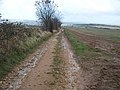
 The Monarch's Way above Broad Campden - geograph.org.uk - 893328.jpg 640 × 426; 90 KB
-

-
 The Mount, Broad Campden-geograph-1949338-by-Michael-Dibb.jpg 4,000 × 3,000; 3.18 MB
-
-
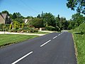
 Towards Broad Campden - geograph.org.uk - 1587417.jpg 640 × 480; 78 KB
-
 View of the farm - geograph.org.uk - 1587296.jpg 640 × 480; 64 KB
-
 View over Broad Campden - geograph.org.uk - 47125.jpg 640 × 414; 177 KB
-

-
 Eastern edge of Broad Campden - geograph.org.uk - 246343.jpg 640 × 480; 93 KB
-
 Entrance to the Campden Business Park - geograph.org.uk - 746092.jpg 640 × 428; 149 KB
-
 Farmland near Broad Campden - geograph.org.uk - 557656.jpg 640 × 428; 103 KB


