Category:Brandeston
Jump to navigation
Jump to search
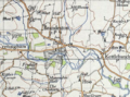
English: Brandeston is a village in Suffolk, England on the River Deben. 'Brandeston Hall', the largest building in the village, is now the preparatory department of nearby Framlingham College. It was largely destroyed in a fire between the Wars and rebuilt. Other buildings in the village are the Queen's Head pub and the mediaeval parish church of All Saints.
village and civil parish in Suffolk, United Kingdom  | |||||
| Upload media | |||||
| Instance of | |||||
|---|---|---|---|---|---|
| Location |
| ||||
 | |||||
Subcategories
This category has the following 7 subcategories, out of 7 total.
A
B
- Brandeston Hall (4 F)
- Brandeston War Memorial (1 F)
P
- The Priory, Brandeston (2 F)
Q
- The Queens Head Inn, Brandeston (11 F)
V
- Brandeston Village Hall (4 F)
- Brandeston Village Sign (4 F)
Media in category "Brandeston"
The following 191 files are in this category, out of 191 total.
-
 'The Queen' at Brandeston - geograph.org.uk - 5361917.jpg 3,456 × 2,592; 3.94 MB
-

-
 1857 Order of exchange of lands. Brandeston, Suffolk. Revd H M Smythe and C Austin. Map.jpg 9,248 × 6,944; 5.99 MB
-
 1857 Order of exchange of lands. Brandeston, Suffolk. Revd H M Smythe and C Austin. Text.png 9,248 × 6,944; 47.28 MB
-

-
 1858. Order of exchange of lands. Brandeston, Suffolk. Revd C Baldwin and C Austin. Map.jpg 9,248 × 6,944; 7.19 MB
-
 1858. Order of exchange of lands. Brandeston, Suffolk. Revd C Baldwin and C Austin. Text.jpg 6,944 × 9,248; 10.53 MB
-
 1858. Order of exchange of lands. Brandeston, Suffolk. Revd H M Smythe and C Austin. Map.jpg 9,248 × 6,944; 9.55 MB
-
 1858. Order of exchange of lands. Brandeston, Suffolk. Revd H M Smythe and C Austin.jpg 4,624 × 3,472; 2.5 MB
-
 All Saints Church, Brandeston - geograph.org.uk - 5716635.jpg 6,000 × 4,000; 4.72 MB
-
 Barns at Chestnut Tree Farm - geograph.org.uk - 5496363.jpg 4,000 × 3,000; 4.94 MB
-
 Boats on the River Hull at Bethell's Bridge (geograph 4804806).jpg 3,648 × 2,736; 3.76 MB
-
 Brandeston Bridge - geograph.org.uk - 339602.jpg 640 × 480; 73 KB
-
 Brandeston Bridge on Old Maid's Lane - geograph.org.uk - 3753758.jpg 3,072 × 2,304; 1.79 MB
-
 Brandeston Car Park ^ Playing Field - geograph.org.uk - 3751510.jpg 3,072 × 2,304; 1.9 MB
-
 Brandeston Ford - geograph.org.uk - 3189281.jpg 3,872 × 2,592; 2.42 MB
-
 Brandeston Hall Playing Field - geograph.org.uk - 3750703.jpg 3,072 × 2,304; 2 MB
-
 Brandeston Hall sign - geograph.org.uk - 3750677.jpg 2,304 × 3,072; 1.91 MB
-
 Brandeston Playing Field - geograph.org.uk - 3751514.jpg 3,072 × 2,304; 1.05 MB
-
 Brandeston Road - geograph.org.uk - 2550716.jpg 2,304 × 3,072; 1.26 MB
-
 Brandeston Road - geograph.org.uk - 2550718.jpg 3,072 × 2,304; 1.26 MB
-
 Brandeston Road - geograph.org.uk - 2550882.jpg 3,072 × 2,304; 1.33 MB
-
 Brandeston Road - geograph.org.uk - 2550889.jpg 3,072 × 2,304; 1.35 MB
-
 Brandeston Road - geograph.org.uk - 2550892.jpg 3,072 × 2,304; 1.26 MB
-
 Brandeston Road crosses Brandeston Bridge - geograph.org.uk - 3598062.jpg 3,478 × 2,639; 1.4 MB
-
 Brandeston Road, Brandeston - geograph.org.uk - 3754992.jpg 3,072 × 2,304; 2.06 MB
-
 Brandeston Village name sign - geograph.org.uk - 2557050.jpg 2,304 × 3,072; 1.63 MB
-
 Brandeston Village Notice Board - geograph.org.uk - 2556664.jpg 2,304 × 3,072; 1.42 MB
-
 Brandeston Village Notice Board - geograph.org.uk - 3751506.jpg 2,304 × 3,072; 1.82 MB
-
 Brandeston, All Saints, church path - geograph.org.uk - 2014319.jpg 480 × 640; 106 KB
-
 Brandeston.png 525 × 388; 527 KB
-
 Bridleway to Mill Lane - geograph.org.uk - 2556674.jpg 2,304 × 3,072; 1.5 MB
-
 Bridleway to Monewden Hall - geograph.org.uk - 3752644.jpg 3,072 × 2,304; 1.96 MB
-
 Bridleway to Monewden Hall - geograph.org.uk - 3752651.jpg 3,072 × 2,304; 2.06 MB
-
 Bus shelter and grit bin - geograph.org.uk - 4374317.jpg 1,024 × 768; 443 KB
-
 By Low Street, Brandeston - geograph.org.uk - 1424527.jpg 640 × 457; 128 KB
-
 Byway Sign in Mill Lane - geograph.org.uk - 2556655.jpg 2,304 × 3,072; 1.65 MB
-
 Chapel House, Brandeston - geograph.org.uk - 1424573.jpg 640 × 480; 108 KB
-
 Chestnut Tree Farm sign - geograph.org.uk - 3755373.jpg 2,746 × 2,063; 1.07 MB
-
 Cottages in Brandeston - geograph.org.uk - 1424538.jpg 640 × 549; 158 KB
-
 Crettingham Lane to Low Street - geograph.org.uk - 3752661.jpg 3,072 × 2,304; 1.8 MB
-
 Damaged fingerpost at Brandeston - geograph.org.uk - 4374249.jpg 1,024 × 768; 260 KB
-
 Damaged fingerpost near Brandeston Bridge - geograph.org.uk - 4374254.jpg 1,024 × 768; 327 KB
-
 Entering Brandeston - geograph.org.uk - 2262283.jpg 640 × 480; 72 KB
-

-
 Entrance of Brandeston Village Hall - geograph.org.uk - 3751515.jpg 3,072 × 2,304; 1.83 MB
-
 Entrance to Brandeston Hall - geograph.org.uk - 3753596.jpg 3,072 × 2,304; 1.81 MB
-
 Entrance to West Hill Farm - geograph.org.uk - 2556924.jpg 2,304 × 3,072; 1.39 MB
-
 Entrance to West Hill Farm - geograph.org.uk - 2556925.jpg 2,304 × 3,072; 1.47 MB
-
 Entrance to West Hill Lodge - geograph.org.uk - 2556921.jpg 2,304 × 3,072; 1.66 MB
-
 Field entrance off Old Maid's Lane - geograph.org.uk - 3750696.jpg 3,072 × 2,304; 1.77 MB
-
 Field off Old Maids' Lane - geograph.org.uk - 3753603.jpg 3,072 × 2,304; 1.64 MB
-
 Flying the flag for Queen and country - geograph.org.uk - 4374329.jpg 1,024 × 768; 339 KB
-
 Footpath - geograph.org.uk - 3790936.jpg 1,024 × 768; 358 KB
-
 Footpath to Brandeston Village Hall ^ Low Lane - geograph.org.uk - 3753606.jpg 3,072 × 2,304; 1.71 MB
-
 Footpath to Friday Street - geograph.org.uk - 3750708.jpg 2,948 × 2,214; 2.08 MB
-
 Footpath to Friday Street - geograph.org.uk - 3750710.jpg 2,304 × 3,072; 2.1 MB
-

-
 Footpath to Hillhouse Farm ^ Kettleburgh Lodge - geograph.org.uk - 3750460.jpg 3,072 × 2,304; 1.89 MB
-
 Footpath to Hillhouse Farm ^ Kettleburgh Lodge - geograph.org.uk - 3750466.jpg 3,072 × 2,172; 1.96 MB
-
 Footpath to Kettleburgh Lodge - geograph.org.uk - 2262262.jpg 640 × 480; 164 KB
-
 Footpath to Kittle's Corner ^ entrance to Chestnut Tree Farm - geograph.org.uk - 3755369.jpg 3,072 × 2,304; 1.08 MB
-
 Footpath to Low Lane - geograph.org.uk - 3753600.jpg 2,304 × 3,072; 1.82 MB
-
 Footpath to Low Lane - geograph.org.uk - 3753602.jpg 3,072 × 2,304; 1.85 MB
-
 Footpath to Low Street - geograph.org.uk - 3750637.jpg 2,304 × 3,072; 1.87 MB
-
 Footpath to Low Street - geograph.org.uk - 3750650.jpg 3,072 × 2,304; 1.8 MB
-
 Footpath to Mill Lane Byway - geograph.org.uk - 2557037.jpg 3,072 × 2,304; 1.45 MB
-
 Footpath to Mill Lane Byway - geograph.org.uk - 2557047.jpg 3,072 × 2,304; 1.4 MB
-
 Footpath to Mutton Lane - geograph.org.uk - 2556650.jpg 2,304 × 3,072; 1.51 MB
-
 Footpath to Mutton Lane - geograph.org.uk - 3751540.jpg 3,072 × 2,304; 1.98 MB
-
 Footpath to Old Maids' Lane - geograph.org.uk - 3755394.jpg 3,072 × 2,304; 1.91 MB
-
 Footpath to Old Maids' Lane - geograph.org.uk - 3755397.jpg 3,072 × 2,304; 1.87 MB
-
 Footpath to Old Maids' Lane ^ Pegways - geograph.org.uk - 3755317.jpg 3,072 × 2,304; 1.63 MB
-
 Footpath to Old Maids' Lane ^ Pegways - geograph.org.uk - 3755333.jpg 3,072 × 2,304; 2.12 MB
-
 Footpath to Swan Lane - geograph.org.uk - 2557042.jpg 2,304 × 3,072; 1.6 MB
-
 Footpath to Swan Lane ^ Brandeston Road - geograph.org.uk - 2550867.jpg 3,072 × 2,304; 1.62 MB
-
 Footpath to Swan Lane ^ Brandeston Road - geograph.org.uk - 2550874.jpg 2,304 × 3,072; 1.24 MB
-
 Footpath to Swan Lane ^ Brandeston Road - geograph.org.uk - 2550876.jpg 2,304 × 3,072; 1.54 MB
-
 Footpath to Swan Lane ^ Brandeston Road - geograph.org.uk - 2550879.jpg 2,304 × 3,072; 1.64 MB
-
 Footpath to the Mill Lane Byway to High Road - geograph.org.uk - 2550862.jpg 3,072 × 2,304; 1.31 MB
-
 Footpath ^ entrance of Hillhouse Farm - geograph.org.uk - 3750478.jpg 3,072 × 2,304; 1.78 MB
-
 Footpath ^ entrance to Hillhouse Farm - geograph.org.uk - 3750472.jpg 3,072 × 2,304; 1.95 MB
-
 Footpath ^ Low Street Postbox - geograph.org.uk - 3749974.jpg 3,072 × 2,304; 2.03 MB
-
 Footpath ^ Low Street Postbox - geograph.org.uk - 3749984.jpg 2,304 × 3,072; 1.97 MB
-
 Footpath ^ Low Street Postbox - geograph.org.uk - 3750003.jpg 3,072 × 2,304; 2.1 MB
-
 Ford at Brandeston - geograph.org.uk - 5496370.jpg 4,000 × 3,000; 4.79 MB
-
 Friday Street junction - geograph.org.uk - 3755094.jpg 3,072 × 2,304; 1.78 MB
-
 Friday Street ^ footpath - geograph.org.uk - 3755312.jpg 3,072 × 2,304; 1.91 MB
-
 Friday Street, Brandeston - geograph.org.uk - 3755261.jpg 3,072 × 2,304; 1.83 MB
-
 Friday Street, Brandeston - geograph.org.uk - 3755284.jpg 3,072 × 2,304; 1.93 MB
-
 Grove Farm - geograph.org.uk - 337642.jpg 640 × 480; 73 KB
-
 Hall Barn, Monewden - geograph.org.uk - 3755421.jpg 3,072 × 1,971; 944 KB
-
 Hanging sign for 'The Queen' - geograph.org.uk - 5361905.jpg 2,592 × 3,456; 3.19 MB
-
 House by Low Street - geograph.org.uk - 1424535.jpg 640 × 427; 93 KB
-
 Into The Distance (2) - geograph.org.uk - 3793041.jpg 1,024 × 768; 245 KB
-
 Isolated house - geograph.org.uk - 1424308.jpg 640 × 477; 80 KB
-
 Lane towards Brandeston - geograph.org.uk - 1424518.jpg 480 × 640; 110 KB
-
 Lane west of Monewden Hall - geograph.org.uk - 1424237.jpg 640 × 439; 85 KB
-
 Leaving the footpath for the road - geograph.org.uk - 2262273.jpg 640 × 480; 124 KB
-
 Looking towards Brandeston Bridge - geograph.org.uk - 3755281.jpg 3,072 × 2,304; 2 MB
-
 Low Lane, Brandeston - geograph.org.uk - 2556642.jpg 3,072 × 2,304; 1.28 MB
-
 Low Street - geograph.org.uk - 2556639.jpg 3,072 × 2,304; 1.53 MB
-
 Low Street Postbox - geograph.org.uk - 3749979.jpg 2,304 × 3,072; 1.88 MB
-
 Low Street Postbox - geograph.org.uk - 3749981.jpg 2,241 × 2,992; 1.65 MB
-
 Low Street Postbox - geograph.org.uk - 3749982.jpg 2,279 × 3,042; 2.11 MB
-
 Low Street ^ Low Street Postbox - geograph.org.uk - 3749967.jpg 3,072 × 2,304; 1.87 MB
-
 Low Street, Brandeston - geograph.org.uk - 3749994.jpg 3,072 × 2,304; 1.69 MB
-
 Low Street, Brandeston - geograph.org.uk - 3749995.jpg 3,072 × 2,304; 1.88 MB
-
 Low Street, Brandeston - geograph.org.uk - 3751518.jpg 3,072 × 2,304; 1.83 MB
-
 Low Street, Brandeston - geograph.org.uk - 3751522.jpg 3,072 × 2,131; 655 KB
-
 Low Street, Brandeston - geograph.org.uk - 3752633.jpg 3,072 × 2,304; 1.91 MB
-
 Low Street, Brandeston, and postbox - geograph.org.uk - 1424532.jpg 640 × 414; 121 KB
-
 Mill Lane - geograph.org.uk - 3791536.jpg 768 × 1,024; 429 KB
-
 Mill Lane Byway - geograph.org.uk - 2556652.jpg 3,072 × 2,304; 1.33 MB
-
 Mill Lane Byway from High Road - geograph.org.uk - 4374353.jpg 1,024 × 768; 414 KB
-
 Mill Lane Byway to Church Lane - geograph.org.uk - 2556658.jpg 2,304 × 3,072; 1.49 MB
-
 Mill Lane byway to High Road - geograph.org.uk - 3751541.jpg 3,072 × 2,304; 1.78 MB
-
 Mill Lane, Brandeston - geograph.org.uk - 2556647.jpg 3,072 × 2,304; 1.51 MB
-
 Mill Lane, Brandeston - geograph.org.uk - 2556648.jpg 2,304 × 3,072; 1.36 MB
-
 Mill Lane, Brandeston - geograph.org.uk - 2556660.jpg 2,304 × 3,072; 1.51 MB
-
 Mill Lane, Brandeston - geograph.org.uk - 3751535.jpg 3,072 × 2,304; 1.95 MB
-
 Mill Lane, byway ^ footpath - geograph.org.uk - 3751537.jpg 3,072 × 2,304; 1.88 MB
-
 Mill Lane, footpath to Earl Soham - geograph.org.uk - 4374346.jpg 1,024 × 768; 654 KB
-
 Monewdon Hall - geograph.org.uk - 289706.jpg 640 × 479; 138 KB
-
 Mutton Lane sign - geograph.org.uk - 3750448.jpg 3,072 × 2,304; 1.85 MB
-
 Mutton Lane, Brandeston - geograph.org.uk - 1224035.jpg 640 × 480; 108 KB
-
 Mutton Lane, Brandeston - geograph.org.uk - 3750449.jpg 3,072 × 2,304; 1.78 MB
-
 Mutton Lane, Brandeston - geograph.org.uk - 3750454.jpg 3,072 × 2,304; 1.84 MB
-
 Mutton Lane, Brandeston - geograph.org.uk - 3750456.jpg 3,072 × 2,304; 2.06 MB
-
 Mutton Lane, Brandeston - geograph.org.uk - 3750479.jpg 3,072 × 2,304; 1.86 MB
-
 Mutton Lane, Brandeston - geograph.org.uk - 3750484.jpg 3,072 × 2,304; 1.82 MB
-
 Mutton Lane, Brandeston - geograph.org.uk - 3750485.jpg 3,072 × 2,304; 1.93 MB
-
 Mutton Lane, Brandeston - geograph.org.uk - 5496373.jpg 4,000 × 3,000; 5.06 MB
-
 Mutton Lane, Brandeston - geograph.org.uk - 5496375.jpg 4,000 × 3,000; 4.82 MB
-
 Old Chapel - geograph.org.uk - 3790932.jpg 768 × 1,024; 203 KB
-
 Old Cottage - geograph.org.uk - 337623.jpg 640 × 480; 77 KB
-
 Old Maid's Lane north of Brandeston Hall - geograph.org.uk - 3597985.jpg 3,552 × 2,493; 1.44 MB
-
 Old Maid's Lane, Brandeston - geograph.org.uk - 3750611.jpg 3,072 × 2,304; 1.85 MB
-
 Old Maid's Lane, Brandeston - geograph.org.uk - 3750632.jpg 3,072 × 2,304; 1.9 MB
-
 Old Maid's Lane, Brandeston - geograph.org.uk - 3750659.jpg 3,072 × 2,304; 1.76 MB
-
 Old Maid's Lane, Brandeston - geograph.org.uk - 3750665.jpg 2,304 × 3,072; 1.85 MB
-
 Old Maid's Lane, Brandeston - geograph.org.uk - 3750695.jpg 3,072 × 2,304; 850 KB
-
 Old Maid's Lane, Brandeston - geograph.org.uk - 3753607.jpg 3,072 × 2,304; 1.85 MB
-
 Old Maid's Lane, Brandeston - geograph.org.uk - 3753760.jpg 3,072 × 2,304; 1.89 MB
-
 Old Maids' Lane junction - geograph.org.uk - 3752659.jpg 3,072 × 2,304; 1.87 MB
-
 Old Maids' Lane ^ bridleway - geograph.org.uk - 3752656.jpg 3,072 × 2,304; 1.79 MB
-
 Old Maids' Lane, Brandeston - geograph.org.uk - 3752650.jpg 3,072 × 2,304; 1.8 MB
-
 Old Maids' Lane, Brandeston - geograph.org.uk - 3752655.jpg 3,072 × 2,304; 1.87 MB
-
 Old Manor Lane - geograph.org.uk - 1424552.jpg 640 × 480; 123 KB
-

-

-
 Pegways ^ footpath - geograph.org.uk - 3755365.jpg 3,072 × 2,304; 1.75 MB
-
 Pegways ^ footpath - geograph.org.uk - 3755382.jpg 3,072 × 2,304; 1.95 MB
-
 Pegways, Brandeston - geograph.org.uk - 3755410.jpg 3,072 × 2,304; 1.91 MB
-
 Pink Cottage - geograph.org.uk - 3667105.jpg 1,024 × 768; 182 KB
-
 Ploughed Field - geograph.org.uk - 3791541.jpg 1,024 × 768; 248 KB
-
 Ploughed Field - geograph.org.uk - 3791546.jpg 1,024 × 768; 295 KB
-
 Pond at Brandeston Hall - geograph.org.uk - 5716436.jpg 6,000 × 4,000; 5.23 MB
-
 Post Office Mill Lane George V Postbox - geograph.org.uk - 2556669.jpg 2,304 × 3,072; 1.41 MB
-
 Priory Lodge sign - geograph.org.uk - 2557043.jpg 3,072 × 2,304; 1.42 MB
-
 Reflections in a pond - geograph.org.uk - 4374348.jpg 1,024 × 768; 627 KB
-
 Reflections in a pond - geograph.org.uk - 4374350.jpg 1,024 × 768; 606 KB
-
 Riggle Street sign - geograph.org.uk - 2556932.jpg 2,304 × 3,072; 1.49 MB
-
 Riggle Street Sign - geograph.org.uk - 338439.jpg 640 × 480; 80 KB
-
 Riggle Street, Brandeston - geograph.org.uk - 2556673.jpg 3,072 × 2,304; 1.41 MB
-
 Riggle Street, Brandeston - geograph.org.uk - 2556679.jpg 2,304 × 3,072; 1.38 MB
-
 Riggle Street, Brandeston - geograph.org.uk - 2556929.jpg 3,072 × 2,304; 1.44 MB
-
 River Deben at Brandeston Bridge - geograph.org.uk - 3753777.jpg 3,072 × 2,304; 1.56 MB
-
 River Deben at Brandeston Bridge - geograph.org.uk - 4374282.jpg 1,024 × 768; 526 KB
-
 River Deben at Brandeston Bridge - geograph.org.uk - 4374283.jpg 1,024 × 768; 514 KB
-
 River Deben at Brandeston Bridge - geograph.org.uk - 4374284.jpg 1,024 × 768; 481 KB
-
 Road to Kittle's Corner - geograph.org.uk - 3755237.jpg 3,072 × 2,304; 2.09 MB
-
 Roadsign on Brandeston Road - geograph.org.uk - 3755000.jpg 2,304 × 3,072; 1.93 MB
-
 Roadsign on Brandeston Road - geograph.org.uk - 3755002.jpg 2,304 × 3,072; 1.84 MB
-
 Roadsign on Friday Street - geograph.org.uk - 3755263.jpg 2,304 × 3,072; 1.84 MB
-
 Roadsign on Friday Street - geograph.org.uk - 3755265.jpg 2,304 × 3,072; 1.9 MB
-
 Roadsign on Low Street - geograph.org.uk - 3752635.jpg 2,304 × 3,072; 1.93 MB
-
 Slip road to Low Street - geograph.org.uk - 3752647.jpg 3,072 × 2,304; 1.95 MB
-
 Small pond beside Mill Lane - geograph.org.uk - 4374342.jpg 1,024 × 768; 636 KB
-
 Thatched house with ladders - geograph.org.uk - 1424569.jpg 640 × 448; 95 KB
-
 The Chapel House, Brandeston - geograph.org.uk - 4374298.jpg 1,024 × 768; 402 KB
-

-

-
 The Manse - geograph.org.uk - 337630.jpg 640 × 480; 104 KB
-
 The Old Wheelwrights sign - geograph.org.uk - 3749999.jpg 3,072 × 2,304; 1.82 MB
-
 The one that got away - geograph.org.uk - 3667695.jpg 1,024 × 768; 169 KB
-
 Three Bridges - geograph.org.uk - 3667703.jpg 768 × 1,024; 321 KB
-
 Tree still in winter mode - geograph.org.uk - 5716646.jpg 6,000 × 4,000; 7.17 MB
-
 View from Mutton Lane - geograph.org.uk - 1224041.jpg 640 × 480; 106 KB
-
 Wall and gates at Brandeston Hall school - geograph.org.uk - 4374300.jpg 1,024 × 768; 509 KB
-


.jpg)


_-_geograph.org.uk_-_3793041.jpg)


