Category:Bourne, Lincolnshire
Jump to navigation
Jump to search
English: Bourne is a market town and civil parish on the western edge of the Fens, in the District of South Kesteven in southern Lincolnshire, England. The town owes its origin to the Roman road upon which it was built, and also to the exceptionally fine-quality water supply derived locally from natural springs. The name “Bourne” (or “Bourn”, as the town was originally known) is a common name for a settlement and derives from the Anglo-Saxon meaning “water” or “stream”. The town lies on the intersection of the A15 and the B1193 (formerly A151) roads at . As well as the main township, the civil parish includes the hamlets of Cawthorpe, Dyke and Twenty.
Nederlands: Bourne is een plaats in het bestuurlijke gebied South Kesteven, in het Engelse graafschap Lincolnshire. De plaats telt 11.933 inwoners.
Română: Bourne este un oraş în comitatul Lincolnshire, regiunea East Midlands, Anglia. Oraşul se află în districtul South Kesteven.
market town in South Kesteven, Lincolnshire, England   | |||||
| Upload media | |||||
| Instance of | |||||
|---|---|---|---|---|---|
| Location | Bourne, South Kesteven, Lincolnshire, East Midlands, England | ||||
 | |||||
Subcategories
This category has the following 18 subcategories, out of 18 total.
Media in category "Bourne, Lincolnshire"
The following 200 files are in this category, out of 1,795 total.
(previous page) (next page)-
 -2021-06-12 Burger Van, Saturday Market, Bourne, Linconshire.jpg 6,252 × 4,164; 6.73 MB
-
 -2021-06-12 Saturday Market, Bourne, Linconshire (1).jpg 6,252 × 4,164; 6.76 MB
-
20210321 0900 Birdsong Bourne Lincolnshire.mp3 1 h 42 min 16 s; 209.41 MB
-

-
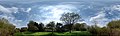 360 degrees around my Orchard (geograph 6444289).jpg 12,097 × 3,600; 7.59 MB
-
 A Bentley for comparison - geograph.org.uk - 5002449.jpg 4,000 × 2,992; 4.46 MB
-
 A Bentley in West Street - geograph.org.uk - 5001175.jpg 6,800 × 4,533; 7.7 MB
-
 A boat full of flowers at Bourne, Lincolnshire - geograph.org.uk - 4324955.jpg 2,848 × 2,134; 1.5 MB
-
 A Brief Tenure - geograph.org.uk - 6104246.jpg 4,032 × 3,024; 2.64 MB
-
 A Chevrolet Pickup - geograph.org.uk - 5001178.jpg 5,800 × 3,867; 7.58 MB
-
 A confusing vehicle - geograph.org.uk - 5001157.jpg 5,800 × 3,867; 7.97 MB
-
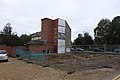
 A construction site has appeared - geograph.org.uk - 6181813.jpg 4,896 × 3,672; 6.86 MB
-
 A day in Bourne - geograph.org.uk - 5985630.jpg 6,032 × 4,014; 3.9 MB
-
 A fenland landscape near Bourne, Lincolnshire - geograph.org.uk - 4321155.jpg 1,184 × 787; 257 KB
-
 A flax crop in the fen near Bourne, Lincolnshire - geograph.org.uk - 4415803.jpg 2,848 × 2,134; 1.49 MB
-
 A mechanism - geograph.org.uk - 4004465.jpg 4,896 × 3,672; 6.84 MB
-
 A network of Scaffold - geograph.org.uk - 6181806.jpg 4,896 × 3,672; 6.64 MB
-
 A new pump head - geograph.org.uk - 5000821.jpg 6,400 × 4,267; 7.45 MB
-
 A nice place to sit - geograph.org.uk - 3582656.jpg 4,608 × 3,456; 4.53 MB
-
 A path through the wood at Bourne, Lincolnshire - geograph.org.uk - 4475696.jpg 2,160 × 1,440; 1.85 MB
-
 A path through the woods at Bourne, Lincolnshire - geograph.org.uk - 4429763.jpg 2,848 × 2,134; 2.11 MB
-
 A professional at work - geograph.org.uk - 4004053.jpg 4,853 × 2,579; 5.66 MB
-
 A sculptor at work - geograph.org.uk - 4511785.jpg 4,320 × 3,240; 5.67 MB
-
 A seat in the wood at Bourne, Lincolnshire - geograph.org.uk - 4484621.jpg 2,160 × 1,440; 1.44 MB
-
 A sign of failure - geograph.org.uk - 5985618.jpg 6,032 × 4,014; 2.12 MB
-
 A snowy day - geograph.org.uk - 5701455.jpg 6,032 × 4,014; 4.82 MB
-
 A stump decay'd - geograph.org.uk - 5538802.jpg 4,032 × 3,024; 5.33 MB
-
 A surprise - geograph.org.uk - 4094962.jpg 4,896 × 3,672; 6.83 MB
-
 A tale of grass cutting - geograph.org.uk - 5538232.jpg 4,032 × 3,024; 6.04 MB
-
 A thing of the past - geograph.org.uk - 5834339.jpg 4,896 × 3,672; 6.88 MB
-
 A trim for the weeping willows at Bourne, Lincolnshire - geograph.org.uk - 4416903.jpg 2,848 × 2,134; 1.81 MB
-
 A view from Meadow Road - geograph.org.uk - 2467922.jpg 640 × 480; 88 KB
-
 A wartime relic at Bourne, Lincolnshire - geograph.org.uk - 4601538.jpg 2,848 × 2,134; 1.62 MB
-
 A welcome seat in Bourne Wood - geograph.org.uk - 5681585.jpg 3,776 × 2,520; 2.74 MB
-
 A15 north of Bourne - geograph.org.uk - 5210884.jpg 1,600 × 994; 387 KB
-
 A151 northbound - geograph.org.uk - 5550935.jpg 640 × 480; 49 KB
-

-
 A151 southbound - geograph.org.uk - 5608799.jpg 640 × 480; 41 KB
-
 A151 westbound - geograph.org.uk - 5608801.jpg 640 × 480; 37 KB
-
 A151 westbound - geograph.org.uk - 5608803.jpg 640 × 480; 41 KB
-
 A151 westbound - geograph.org.uk - 5608805.jpg 640 × 480; 59 KB
-
 A151 westbound - geograph.org.uk - 5608808.jpg 640 × 480; 71 KB
-
 A151 westbound - geograph.org.uk - 5886673.jpg 640 × 443; 46 KB
-
 A151 westbound - geograph.org.uk - 5886679.jpg 640 × 480; 44 KB
-
 Abandoned gateway on South Fen Road - geograph.org.uk - 3837317.jpg 4,320 × 3,240; 5.48 MB
-
 Abbey Lawns - geograph.org.uk - 3688811.jpg 4,896 × 3,264; 6.06 MB
-
 Accident site - geograph.org.uk - 3702454.jpg 4,896 × 3,672; 6.98 MB
-
 Aesculus hippocastanum - geograph.org.uk - 4702091.jpg 3,462 × 2,308; 2.51 MB
-
 After the singing - geograph.org.uk - 3972462.jpg 4,896 × 3,672; 6.58 MB
-

-
 Algae on the river at Bourne, Lincolnshire - geograph.org.uk - 4292947.jpg 2,848 × 2,134; 1.43 MB
-
 Algae on the river at Bourne, Lincolnshire - geograph.org.uk - 4388805.jpg 2,848 × 2,134; 1.51 MB
-
 All fenced in - geograph.org.uk - 4450529.jpg 4,320 × 3,240; 5.5 MB
-
 All is safely gathered in at Bourne, Lincolnshire - geograph.org.uk - 4369879.jpg 1,799 × 1,231; 610 KB
-
 All sorts of green - geograph.org.uk - 4450467.jpg 4,320 × 3,240; 5.88 MB
-
 All that remains - geograph.org.uk - 3234621.jpg 4,608 × 3,456; 4.4 MB
-
 Allotment fruit and veg at Bourne, Lincolnshire - geograph.org.uk - 4558841.jpg 2,701 × 1,875; 1.87 MB
-
 Allotment scarecrow at Bourne, Lincolnshire - geograph.org.uk - 4282446.jpg 2,720 × 2,002; 2.23 MB
-
 Allotments in the South Fen at Bourne, Lincolnshire - geograph.org.uk - 4315806.jpg 2,160 × 1,440; 659 KB
-
 Allotments off South Fen Road, Bourne - geograph.org.uk - 4408581.jpg 3,776 × 2,520; 3.82 MB
-
 Allotments on South Fen Road, Bourne - geograph.org.uk - 3856547.jpg 4,320 × 3,240; 6.04 MB
-
 Ambulance in a hurry - geograph.org.uk - 3268756.jpg 4,320 × 3,240; 5.09 MB
-
 Ambulance in North Street - geograph.org.uk - 5561958.jpg 4,320 × 2,880; 4.86 MB
-
 An Aging population. - geograph.org.uk - 5715230.jpg 6,032 × 4,014; 5.73 MB
-
 An easier passage - geograph.org.uk - 4542637.jpg 4,800 × 3,200; 4.04 MB
-
 Anagallis arvensis - geograph.org.uk - 4544985.jpg 2,500 × 2,500; 3.31 MB
-
 Anchor Inn - geograph.org.uk - 3257244.jpg 4,320 × 3,240; 5.55 MB
-
 Ancient brickwork at Bourne, Lincolnshire - geograph.org.uk - 4519791.jpg 2,848 × 2,134; 1.96 MB
-
 Ancient meadow for a royal occasion at Bourne, Lincolnshire - geograph.org.uk - 4975744.jpg 2,848 × 2,134; 1.82 MB
-
 Ancient millstone preserved at Bourne, Lincolnshire - geograph.org.uk - 4361767.jpg 2,483 × 1,826; 2.26 MB
-
 Anemone nemorosa - geograph.org.uk - 4450451.jpg 4,320 × 3,240; 5.12 MB
-
 Angel statue in the cemetery at Bourne, Lincolnshire - geograph.org.uk - 4525294.jpg 2,806 × 2,052; 2.46 MB
-
 Another empty shop - geograph.org.uk - 5834362.jpg 4,896 × 3,672; 6.48 MB
-
 Another one^ - geograph.org.uk - 5715256.jpg 4,014 × 6,032; 3.18 MB
-
 Antenna farm - geograph.org.uk - 3690377.jpg 4,896 × 3,264; 6.03 MB
-
 Antique centre yard - geograph.org.uk - 4701840.jpg 3,462 × 2,308; 2.76 MB
-
 Apple Blossom - geograph.org.uk - 3972499.jpg 4,896 × 3,672; 6.57 MB
-
 Approaching shower on Barnes Drove - geograph.org.uk - 2467919.jpg 640 × 480; 101 KB
-
 Approaching the north end of Bourne Wood (Fox Wood) - geograph.org.uk - 5681641.jpg 3,776 × 2,520; 3.72 MB
-
 Arboreal Puzzle - geograph.org.uk - 4032284.jpg 4,896 × 3,672; 6.83 MB
-
 Arms of South Kesteven Rural District Council - geograph.org.uk - 3588810.jpg 4,320 × 3,240; 5.52 MB
-
 Army cadet headquarters at Bourne, Lincolnshire - geograph.org.uk - 4603786.jpg 1,757 × 1,189; 659 KB
-
 Arrested Development - geograph.org.uk - 3688344.jpg 4,896 × 3,264; 5.95 MB
-
 Arrowslit window - geograph.org.uk - 4771898.jpg 3,333 × 5,000; 5.57 MB
-
 Arum maculatum - geograph.org.uk - 3606762.jpg 4,320 × 3,240; 5.35 MB
-
 Arum maculatum - geograph.org.uk - 3606778.jpg 4,320 × 3,240; 5.42 MB
-

-
 Automatic Artistry - geograph.org.uk - 3716792.jpg 4,896 × 3,264; 6.52 MB
-
 Autumn approaches in Bourne Wood, Lincolnshire - geograph.org.uk - 4542009.jpg 1,786 × 1,239; 1.11 MB
-
 Autumn at last - geograph.org.uk - 3716186.jpg 4,896 × 3,672; 7.33 MB
-
 Autumn Blossom - geograph.org.uk - 4229072.jpg 2,994 × 2,537; 2.95 MB
-
 Autumn colour in the suburbs - geograph.org.uk - 3716189.jpg 4,896 × 3,672; 7.1 MB
-
 Autumn colour in the suburbs - geograph.org.uk - 3727415.jpg 4,896 × 3,672; 6.84 MB
-
 Autumn in Eastgate at Bourne, Lincolnshire - geograph.org.uk - 4420033.jpg 2,848 × 2,134; 2.2 MB
-
 Autumn in the woods at Bourne, Lincolnshire - geograph.org.uk - 4429768.jpg 2,848 × 2,134; 2.22 MB
-
 Autumn in Woodland Avenue, Bourne, Lincolnshire - geograph.org.uk - 4364598.jpg 2,160 × 1,440; 959 KB
-
 Autumn is coming - geograph.org.uk - 3588024.jpg 4,320 × 3,240; 5.56 MB
-
 Autumn leaves - geograph.org.uk - 3652127.jpg 4,896 × 3,672; 7.19 MB
-
 Autumn Leaves - geograph.org.uk - 4722259.jpg 3,240 × 2,160; 3.44 MB
-
 Autumn leaves in Eastgate, Bourne, Lincolnshire - geograph.org.uk - 4354553.jpg 1,762 × 1,192; 1.17 MB
-
 Autumnal Hedgerow - geograph.org.uk - 4722246.jpg 3,240 × 2,160; 3.65 MB
-
 Awaiting collection - geograph.org.uk - 3271868.jpg 4,320 × 3,240; 5.73 MB
-
 Awaiting the combine near Bourne, Lincolnshire - geograph.org.uk - 4280831.jpg 2,848 × 2,134; 1.6 MB
-
 Back garden - geograph.org.uk - 3790004.jpg 2,048 × 1,536; 1.07 MB
-
 Back garden visitor at Bourne, Lincolnshire - geograph.org.uk - 4570308.jpg 1,815 × 1,422; 847 KB
-
 Back gardens - geograph.org.uk - 3587432.jpg 4,320 × 3,240; 5.62 MB
-
 Back of the Buffs Hall - geograph.org.uk - 4503183.jpg 4,320 × 3,240; 5.84 MB
-
 Back of the crescent - geograph.org.uk - 4188097.jpg 4,896 × 3,672; 6.35 MB
-
 Baling pea vine at Bourne, Lincolnshire - geograph.org.uk - 4442747.jpg 2,848 × 2,043; 1.68 MB
-
 Basket work for sale at Bourne market, Lincolnshire - geograph.org.uk - 4391621.jpg 2,391 × 1,688; 1.63 MB
-
 Bay window, arched doorway - geograph.org.uk - 3705763.jpg 4,896 × 3,264; 6.11 MB
-
 Bed shed - geograph.org.uk - 5020013.jpg 6,000 × 4,000; 7.08 MB
-
 Beech Avenue in the snow - geograph.org.uk - 5698949.jpg 6,032 × 4,014; 3.02 MB
-
 Beech Avenue with falling snow - geograph.org.uk - 5624558.jpg 6,032 × 4,014; 7.54 MB
-
 Beginnings of the Thaw by the Eau - geograph.org.uk - 5698729.jpg 6,032 × 4,014; 3.54 MB
-
 Behind Saxonhurst - geograph.org.uk - 5000826.jpg 6,400 × 4,267; 7.46 MB
-
 Behind the frontage - geograph.org.uk - 3688740.jpg 3,264 × 4,896; 3.79 MB
-
 Behind the Red Hall - geograph.org.uk - 5001167.jpg 6,800 × 4,533; 7.91 MB
-
 Bellis perennis - geograph.org.uk - 4545222.jpg 4,320 × 4,320; 6.91 MB
-
 Berries - geograph.org.uk - 4723613.jpg 3,240 × 2,160; 1.54 MB
-
 Berries in Manning Road - geograph.org.uk - 3688000.jpg 4,896 × 3,264; 6.08 MB
-
 Best view in Eastgate^ - geograph.org.uk - 3257038.jpg 4,320 × 3,240; 5.47 MB
-
 Beware of pedestrians - geograph.org.uk - 3746606.jpg 4,896 × 3,264; 6.07 MB
-
 Beyond the passageway - geograph.org.uk - 3693899.jpg 3,264 × 4,896; 3.31 MB
-
 Big Lorry - geograph.org.uk - 5543013.jpg 5,800 × 3,867; 7.96 MB
-
 Bird feeders in the Woods - geograph.org.uk - 3268777.jpg 4,320 × 3,240; 5.81 MB
-
 Black and White police car - geograph.org.uk - 4443857.jpg 4,000 × 2,248; 2.18 MB
-
 Black Sluice pumping station - geograph.org.uk - 4649190.jpg 640 × 480; 75 KB
-
 Black swan and cygnets at St Peter’s Pool, Bourne, Lincolnshire - geograph.org.uk - 4365925.jpg 2,359 × 1,735; 1,003 KB
-

-
 Black Swans - geograph.org.uk - 3700396.jpg 640 × 480; 142 KB
-
 Blacklands - geograph.org.uk - 3234666.jpg 4,608 × 3,456; 3.87 MB
-
 Blackthorn blossom - geograph.org.uk - 4438424.jpg 4,000 × 3,000; 2.21 MB
-
 Blacktop going down - geograph.org.uk - 3967317.jpg 4,896 × 3,672; 6.56 MB
-
 Blind Well (Chalybeate) - geograph.org.uk - 2747141.jpg 2,592 × 1,944; 2.19 MB
-
 Blind Well stream - geograph.org.uk - 3587729.jpg 4,320 × 3,240; 5.95 MB
-
 Blossom in the playground - close-up - geograph.org.uk - 3465822.jpg 4,320 × 3,240; 5.46 MB
-
 Blossom in the playground - geograph.org.uk - 3465819.jpg 4,320 × 3,240; 5.9 MB
-
 Blue plaque for Charles Worth at Bourne, Lincolnshire - geograph.org.uk - 4368654.jpg 2,002 × 1,293; 639 KB
-
 Blue Sky on South Fen Road - geograph.org.uk - 2574094.jpg 800 × 600; 182 KB
-
 Bluebells in Diana's Glade - geograph.org.uk - 4468271.jpg 4,320 × 3,240; 5.68 MB
-
 Blues and twos - geograph.org.uk - 5543539.jpg 5,800 × 3,867; 7.17 MB
-
 Boardwalk in the Well Head Fields - geograph.org.uk - 6223206.jpg 1,024 × 768; 287 KB
-
 Bog oaks in the fen near Bourne, Lincolnshire - geograph.org.uk - 4341953.jpg 2,358 × 1,634; 1.29 MB
-
 Bomb site garage at Bourne, Lincolnshire - geograph.org.uk - 4532771.jpg 1,702 × 1,115; 665 KB
-
 Bone Rendering plant in Bourne - geograph.org.uk - 145628.jpg 640 × 427; 80 KB
-
 Bottle banks at Bourne, Lincolnshire - geograph.org.uk - 4376528.jpg 1,787 × 1,185; 712 KB
-
 Boundary marker in the cemetery at Bourne, Lincolnshire - geograph.org.uk - 4359365.jpg 1,763 × 1,196; 967 KB
-
 Boundary wall at the cemetery in Bourne, Lincolnshire - geograph.org.uk - 4303983.jpg 1,776 × 1,240; 1,016 KB
-
 Bounre Police station, above the door-Geograph-2296144-by-Bob-Harvey.jpg 4,000 × 2,248; 2.3 MB
-
 Bourne 1 - geograph.org.uk - 2868907.jpg 1,024 × 768; 354 KB
-
 Bourne Abbey, The West exterior - geograph.org.uk - 6009632.jpg 6,397 × 7,946; 7.67 MB
-
 Bourne Academy - geograph.org.uk - 3746598.jpg 4,896 × 3,264; 6.42 MB
-
 Bourne Almshouses - geograph.org.uk - 6194808.jpg 1,868 × 1,198; 1.84 MB
-
 Bourne Almshouses - geograph.org.uk - 6194809.jpg 1,920 × 1,280; 2.38 MB
-
 Bourne bus station in the Fog - geograph.org.uk - 4173637.jpg 4,896 × 3,672; 6.66 MB
-
 Bourne Bypass - geograph.org.uk - 3268800.jpg 4,320 × 3,240; 5.34 MB
-
 Bourne Cemetery - geograph.org.uk - 1577791.jpg 640 × 480; 101 KB
-
 Bourne Cemetery - geograph.org.uk - 5865101.jpg 6,032 × 4,014; 6.08 MB
-
 Bourne centre, aerial 2014 - geograph.org.uk - 4059674.jpg 640 × 427; 92 KB
-
 Bourne Drove - geograph.org.uk - 5511693.jpg 640 × 480; 44 KB
-
 Bourne Eau - geograph.org.uk - 3234657.jpg 4,608 × 3,456; 5.06 MB
-
 Bourne Eau - geograph.org.uk - 3257253.jpg 4,320 × 3,240; 5.58 MB
-
 Bourne Eau - geograph.org.uk - 3612030.jpg 640 × 480; 108 KB
-
 Bourne Eau - geograph.org.uk - 3652232.jpg 4,896 × 3,264; 6.53 MB
-
 Bourne Eau - geograph.org.uk - 3696993.jpg 640 × 480; 83 KB
-
 Bourne Eau - geograph.org.uk - 3700389.jpg 640 × 480; 113 KB
-
 Bourne Eau - geograph.org.uk - 3718779.jpg 480 × 640; 125 KB
-
 Bourne Eau - geograph.org.uk - 3791071.jpg 4,896 × 3,672; 7.06 MB
-
 Bourne Eau - geograph.org.uk - 3791072.jpg 4,896 × 3,672; 6.57 MB
-
 Bourne Eau - geograph.org.uk - 3791115.jpg 4,896 × 3,672; 7.04 MB
-
 Bourne Eau - geograph.org.uk - 3858828.jpg 4,896 × 3,672; 6.89 MB
-
 Bourne Eau - geograph.org.uk - 404360.jpg 640 × 480; 62 KB
-
 Bourne Eau - geograph.org.uk - 4339546.jpg 4,896 × 3,672; 6.89 MB
-
 Bourne Eau - geograph.org.uk - 4897144.jpg 5,600 × 3,733; 7.88 MB
-
 Bourne Eau and Baldock's Mill - geograph.org.uk - 6223169.jpg 1,024 × 768; 163 KB
-
 Bourne Eau and South Street - geograph.org.uk - 4693616.jpg 3,462 × 2,308; 4.02 MB
-
 Bourne Eau and South Street - geograph.org.uk - 4693617.jpg 3,462 × 2,308; 3.74 MB
-
 Bourne Eau behind the houses - geograph.org.uk - 3234647.jpg 4,608 × 3,456; 4.73 MB
-
 Bourne Eau behind the houses - geograph.org.uk - 3234648.jpg 4,608 × 3,456; 5.04 MB
-
 Bourne Eau from the Eau Terrace - geograph.org.uk - 5000832.jpg 5,400 × 3,600; 7.81 MB
-
 Bourne Eau in Church Walk - geograph.org.uk - 4788737.jpg 5,000 × 3,333; 6.26 MB
-
 Bourne Eau Pumping Station - geograph.org.uk - 437357.jpg 640 × 477; 104 KB
-
 Bourne Fields - geograph.org.uk - 3623540.jpg 640 × 427; 95 KB
-
Bourne Garden 2020-08-28 0843.mp3 1 h 2 min 6 s; 84.08 MB
-
Bourne Garden 2020-08-28 0943.mp3 20 min 20 s; 27.96 MB
-
 Bourne Hospital, Lincolnshire - geograph.org.uk - 4309179.jpg 1,805 × 1,247; 745 KB
-
 Bourne in Bloom - geograph.org.uk - 4542627.jpg 6,480 × 4,320; 7.73 MB
-
 Bourne in Bloom - geograph.org.uk - 5715308.jpg 6,032 × 4,014; 5.12 MB
-
 Bourne institutions - geograph.org.uk - 5164039.jpg 4,000 × 2,992; 4.55 MB
-
 Bourne Lawn Tennis Club - geograph.org.uk - 3718771.jpg 640 × 480; 99 KB
-
 Bourne Lido - geograph.org.uk - 3718764.jpg 640 × 480; 89 KB
-
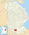 Bourne Lincolnshire UK parish map.svg 1,086 × 1,305; 3.7 MB
-
 Bourne Lions - geograph.org.uk - 3782012.jpg 4,896 × 3,672; 6.6 MB
-
 Bourne Motor Racing Memorial - geograph.org.uk - 3718776.jpg 640 × 480; 133 KB
-
 Bourne North Fen - geograph.org.uk - 4715594.jpg 4,608 × 3,456; 3.42 MB
-
 Bourne North Fen - geograph.org.uk - 983625.jpg 640 × 427; 85 KB
-
 Bourne outdoor pool - geograph.org.uk - 3652197.jpg 3,934 × 1,935; 2.28 MB
-
 Bourne Police station - geograph.org.uk - 2296141.jpg 4,000 × 2,248; 2.13 MB
-
 Bourne Police station in context-Geograph-2296135-by-Bob-Harvey.jpg 4,000 × 2,248; 1.91 MB

.jpg)
.jpg)


_-_geograph.org.uk_-_5681641.jpg)


_-_geograph.org.uk_-_2747141.jpg)


.jpg)