Category:Bosch en Vaart (Vries)
Jump to navigation
Jump to search
| Object location | | View all coordinates using: OpenStreetMap |
|---|
| Upload media | |||||
| Instance of | |||||
|---|---|---|---|---|---|
| Part of | |||||
| Location | Vries, Drenthe, Netherlands | ||||
| Street address |
| ||||
| Located on street |
| ||||
| Heritage designation |
| ||||
 | |||||
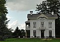
Nederlands: Bosch en Vaart, Groningerstraat, Vries (gem. Tynaarlo, Drenthe), rmc 478014. Dit rijksmonumentcomplex omvat:
- landhuis (Groningerstraat 30, 1881, rm 478155) (gebouwd in opdracht van H.G. Inden)
- orangerie (ca. 1890, rm 478156)
- stookhok (ca. 1890, rm 478157)
- tuinkoepel (ca. 1890, rm 478158)
- koetshuis (Groningerstraat 32, ca. 1890, rm 478159)
|
This is a category about rijksmonumentcomplex number 478014
|
|
This is a category about rijksmonument number 478155
|
|
This is a category about rijksmonument number 478156
|
|
This is a category about rijksmonument number 478157
|
|
This is a category about rijksmonument number 478158
|
|
This is a category about rijksmonument number 478159
|
Media in category "Bosch en Vaart (Vries)"
The following 2 files are in this category, out of 2 total.
-
 20150319 Bosch en Vaart Vries Dr NL.jpg 5,800 × 2,900; 10.27 MB
-
 Bosch en Vaart Vries.jpg 640 × 449; 82 KB

