Category:Boats in Northern Ireland
Jump to navigation
Jump to search
Constituent countries of the United Kingdom: England · Northern Ireland · Scotland · Wales – British Crown dependencies: the Bailiwick of Guernsey ≈ Bailiwick of Guernsey · the Isle of Man ≈ Isle of Man · Jersey
British overseas territories: Akrotiri and Dhekelia · Anguilla · Bermuda · the British Antarctic Territory ≈ British Antarctic Territory · the British Indian Ocean Territory ≈ British Indian Ocean Territory · the British Virgin Islands ≈ British Virgin Islands · the Cayman Islands ≈ Cayman Islands · the Falkland Islands ≈ Falkland Islands · Gibraltar · the Pitcairn Islands ≈ Pitcairn Islands · Saint Helena, Ascension and Tristan da Cunha · South Georgia and the South Sandwich Islands · the Turks and Caicos Islands ≈ Turks and Caicos Islands
British overseas territories: Akrotiri and Dhekelia · Anguilla · Bermuda · the British Antarctic Territory ≈ British Antarctic Territory · the British Indian Ocean Territory ≈ British Indian Ocean Territory · the British Virgin Islands ≈ British Virgin Islands · the Cayman Islands ≈ Cayman Islands · the Falkland Islands ≈ Falkland Islands · Gibraltar · the Pitcairn Islands ≈ Pitcairn Islands · Saint Helena, Ascension and Tristan da Cunha · South Georgia and the South Sandwich Islands · the Turks and Caicos Islands ≈ Turks and Caicos Islands
Subcategories
This category has the following 9 subcategories, out of 9 total.
Media in category "Boats in Northern Ireland"
The following 89 files are in this category, out of 89 total.
-

-
 Ballintoy Harbour - geograph.org.uk - 19750.jpg 640 × 427; 78 KB
-
 Ballydugan Lake (09), January 2010.JPG 4,272 × 2,848; 6.36 MB
-
 Boating near Carnfunnock - geograph.org.uk - 1898078.jpg 640 × 480; 49 KB
-
 Boats at Drumcraw - geograph.org.uk - 375298.jpg 640 × 480; 88 KB
-
 Boats in Carrickfergus Harbour - geograph.org.uk - 1584002.jpg 640 × 480; 106 KB
-
 Cairnryan Ferry Lifeboat (12295040845).jpg 5,760 × 3,840; 11.73 MB
-
 Canlough 1.jpg 640 × 480; 66 KB
-
 Canoe Trail sign, August 2009.JPG 4,272 × 2,848; 4.16 MB
-
 Carrickfergus Castle, County Antrim (16192309048).jpg 3,000 × 1,417; 823 KB
-
 Carrickfergus from East Pier (13733536973).jpg 2,049 × 1,387; 853 KB
-
 Coastguard launch on Lough Neagh - geograph.org.uk - 374819.jpg 640 × 426; 143 KB
-

-
 Davy Jones's Locker on land - geograph.org.uk - 873845.jpg 640 × 480; 121 KB
-
 Donaghadee Harbour, County Down (16192309268).jpg 3,000 × 1,966; 870 KB
-
 Dredging Donaghadee harbour 2010-5 - geograph.org.uk - 1817392.jpg 705 × 534; 89 KB
-

-
 Dundrum Boat Park (03), January 2010.JPG 4,272 × 2,848; 4.9 MB
-
 Dunseverick Harbour - geograph.org.uk - 24159.jpg 640 × 427; 93 KB
-
 Entering Bangor marina - geograph.org.uk - 448432.jpg 640 × 427; 110 KB
-
 Evening all - geograph.org.uk - 180656.jpg 640 × 426; 119 KB
-
 Fishing boat near Groomsport - geograph.org.uk - 2262164.jpg 640 × 351; 78 KB
-
 Fishing in Ballintoy Harbour - geograph.org.uk - 130507.jpg 640 × 479; 129 KB
-
 HMS "Brecon" in the Bann - geograph.org.uk - 631458.jpg 640 × 385; 73 KB
-
 Lifeboat, Ardglass - geograph.org.uk - 2405564.jpg 640 × 354; 111 KB
-
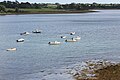
 Lough Neagh passenger trips - geograph.org.uk - 196755.jpg 640 × 426; 151 KB
-
 Maria Lena.jpg 3,858 × 2,073; 764 KB
-
 Mourne Mist - a Carlingford Pilot Boat - geograph.org.uk - 2301638.jpg 1,024 × 606; 108 KB
-
 Newcastle Harbour, May 2010 (04).JPG 4,272 × 2,848; 4.66 MB
-
 Newcastle Yacht Club, May 2010 (03).JPG 2,848 × 4,272; 3.72 MB
-
 Portadown (163), September 2009.JPG 4,272 × 2,848; 5.1 MB
-
 Portaferry, gates (01), October 2009.JPG 2,848 × 4,272; 4.5 MB
-
 Portrush Harbour - geograph.org.uk - 12352.jpg 640 × 341; 162 KB
-
 Portstewart harbour - geograph.org.uk - 219818.jpg 640 × 426; 155 KB
-
 Portstewart Harbour - geograph.org.uk - 24196.jpg 640 × 427; 86 KB
-
 Rathlin Harbour - geograph.org.uk - 469398.jpg 640 × 408; 193 KB
-

-
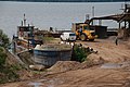 Sand quay, Lough Neagh - geograph.org.uk - 197818.jpg 640 × 426; 151 KB
-
 Seatruck vessel heading for Warrenpoint - geograph.org.uk - 4685456.jpg 1,600 × 1,161; 295 KB
-
 Ships departing Belfast - geograph.org.uk - 5498211.jpg 1,280 × 1,280; 1.16 MB
-

-
 Strangford boat (01), October 2009.JPG 4,272 × 2,848; 4.85 MB
-
 Strangford boat (02), October 2009.JPG 2,848 × 4,272; 4.72 MB
-
 Strangford Lough (04), August 2009.JPG 4,272 × 2,848; 5.76 MB
-
 Strangford Lough (05), August 2009.JPG 4,272 × 2,848; 5.03 MB
-
 Strangford Lough (07), August 2009.JPG 2,848 × 4,272; 4.6 MB
-
 Strangford Lough from Portaferry, looking towards the narrows.JPG 2,592 × 1,944; 2.63 MB
-
 Strangford, village green, October 2009.JPG 4,272 × 2,848; 4.56 MB
-
 Tender at Lough Erne - geograph.org.uk - 366509.jpg 640 × 479; 70 KB
-
 The "Maria", Belfast Lough - geograph.org.uk - 2354291.jpg 800 × 485; 103 KB
-
 The "Sgt Pepper" at Donaghadee - geograph.org.uk - 2435929.jpg 848 × 507; 136 KB
-
 The "Swansea Bay" at Bangor - geograph.org.uk - 561290.jpg 634 × 365; 50 KB
-
 The "Swiftsure" at Donaghadee - geograph.org.uk - 2405715.jpg 640 × 427; 84 KB
-

-
 The 'Aeolus' off Mew Island - geograph.org.uk - 5498126.jpg 1,280 × 687; 609 KB
-
 The 'Andante' departing Belfast - geograph.org.uk - 5498201.jpg 1,280 × 788; 837 KB
-
 The 'Blue Aquarius' at Lighthouse Island - geograph.org.uk - 2465150.jpg 640 × 483; 102 KB
-
 The 'Bramau' off Bangor - geograph.org.uk - 1971091.jpg 640 × 374; 39 KB
-
 The 'Bramau' off Bangor - geograph.org.uk - 1971096.jpg 640 × 438; 56 KB
-
 The 'Cable Enterprise' off Bangor - geograph.org.uk - 3459390.jpg 640 × 640; 93 KB
-
 The 'Coastal Deniz' at Belfast - geograph.org.uk - 2367054.jpg 640 × 428; 48 KB
-
 The 'Corryvreckan' at Rathlin Island - geograph.org.uk - 1931939.jpg 640 × 507; 85 KB
-
 The 'Imelda M' at Rathlin Island - geograph.org.uk - 3029590.jpg 640 × 478; 134 KB
-
 The 'Island Star' at Rathlin - geograph.org.uk - 2474042.jpg 640 × 489; 95 KB
-
 The 'Mytilus' at Bangor - geograph.org.uk - 1951900.jpg 640 × 489; 110 KB
-
 The 'Normand Pacific' off Bangor - geograph.org.uk - 5478274.jpg 1,280 × 720; 658 KB
-
 The 'Ophelia' at Bangor - geograph.org.uk - 1902512.jpg 640 × 499; 483 KB
-
 The 'Silver River' off Mew Island - geograph.org.uk - 5498122.jpg 1,280 × 718; 779 KB
-
 The 'St Sorney' at Rathlin Island - geograph.org.uk - 3029584.jpg 640 × 480; 76 KB
-
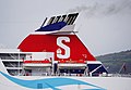
 The 'Stena Mersey' off Bangor - geograph.org.uk - 5482726.jpg 1,280 × 720; 665 KB
-

-

-

-
-
-
 The Belfast Lough water taxi - geograph.org.uk - 226955.jpg 640 × 426; 156 KB
-

-
 The still waters of Glenarm Marina - geograph.org.uk - 4417907.jpg 640 × 480; 138 KB
-
 The Strand (05), Portaferry, October 2009.JPG 4,272 × 2,848; 3.48 MB
-
 Trawler FR73 fishing off Galboly - geograph.org.uk - 1897841.jpg 640 × 480; 39 KB
-
 Trawler HL41 fishing off Galboly - geograph.org.uk - 1897833.jpg 640 × 480; 50 KB
-

-
 Two ships off Bangor - geograph.org.uk - 4034965.jpg 640 × 409; 80 KB
-
 At the wheel, Gypsy Lady - geograph.org.uk - 1418558.jpg 640 × 479; 46 KB
-
 Boat moored at Doss Bay - geograph.org.uk - 339040.jpg 640 × 479; 80 KB
-
 Boat moored at Tom's Island - geograph.org.uk - 423326.jpg 480 × 640; 154 KB
-
 Boats, Lough Erne - geograph.org.uk - 1418554.jpg 640 × 479; 65 KB
-
 Interior of "The Lady of the Lake" - geograph.org.uk - 485038.jpg 640 × 480; 58 KB
-
 Meet Fred^ - geograph.org.uk - 356916.jpg 640 × 479; 78 KB


,_January_2010.JPG)


.jpg)


.jpg)
.jpg)


.jpg)

_-_geograph.org.uk_-_2229626.jpg)
,_January_2010.JPG)


.JPG)
.JPG)
,_September_2009.JPG)
,_October_2009.JPG)


_-_geograph.org.uk_-_751643.jpg)


_-_geograph.org.uk_-_5745094.jpg)
,_October_2009.JPG)
,_October_2009.JPG)
,_August_2009.JPG)
,_August_2009.JPG)
,_August_2009.JPG)


_-_geograph.org.uk_-_6010800.jpg)


,_Portaferry,_October_2009.JPG)


