Category:Blutturm (Bern)
Jump to navigation
Jump to search
| Object location | | View all coordinates using: OpenStreetMap |
|---|
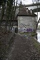
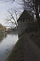
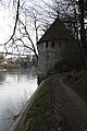
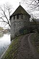
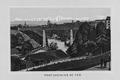
Deutsch: Der Blutturm war Bestandteil der historischen Stadtmauer von Bern und begrenzte diese am nördlichen Ende am Aareufer. Die Lage in der Stadtmauer ist hier ersichtlich. Es ist nicht nachgewiesen, dass im Blutturm Enthauptungen stattfanden und somit die Namensgebung unbelegt.
English: The «Blutturm» (Blood tower) was part of the historic city wall of Berne which it limited at the northern end at the Aar river. The location in the city wall is visible here. There is no evidence that beheadings took place in the «Blutturm». Therefore the naming is not proved.
tower in the city of Bern, Switzerland  | |||||
| Upload media | |||||
| Instance of | |||||
|---|---|---|---|---|---|
| Part of | |||||
| Location | Red Quarter, Inner City, Bern, Bern-Mittelland administrative district, Bernese Mittelland administrative region, Bern, Switzerland | ||||
| Located in or next to body of water | |||||
| Street address |
| ||||
| Heritage designation | |||||
| Inception |
| ||||
 | |||||
Media in category "Blutturm (Bern)"
The following 26 files are in this category, out of 26 total.
-
 Bern - Blutturm.jpg 1,536 × 2,048; 604 KB
-
 Bern Blutturm P6A3145.JPG 3,840 × 5,760; 9.11 MB
-
 Bern Blutturm P6A3148.JPG 3,840 × 5,760; 8.4 MB
-
 Bern Blutturm P6A3153.JPG 3,840 × 5,760; 8.54 MB
-
 Bern Blutturm P6A3157.JPG 3,840 × 5,760; 8.24 MB
-
 Bern Blutturm P6A3161.JPG 3,840 × 5,760; 8.22 MB
-
 Bern Blutturm P6A3167.JPG 3,840 × 5,760; 6.74 MB
-
 Bern Blutturm P6A3176.JPG 3,840 × 5,760; 7.6 MB
-
 Bern Blutturm P6A3182.JPG 3,840 × 5,760; 8.27 MB
-
 Bern Blutturm P6A3190.JPG 3,840 × 5,760; 8.46 MB
-
 Bern Blutturm P6A3192.JPG 3,840 × 5,760; 8.72 MB
-
 Bern Blutturm P6A3195.JPG 3,840 × 5,760; 7.12 MB
-
 Bern Blutturm P6A3196.JPG 3,840 × 5,760; 7.34 MB
-
 Bern Blutturm P6A3200.JPG 3,840 × 5,760; 6.36 MB
-
 Bern Canton - panoramio (308).jpg 4,272 × 2,848; 6.93 MB
-
 Bern Canton - panoramio (315).jpg 4,272 × 2,848; 8.24 MB
-
 Bern, Blutturm an der Aare.jpg 3,854 × 2,891; 8.33 MB
-
 Blutturm Bern 01 10.jpg 1,049 × 1,575; 1.29 MB
-
 Blutturm Bern 01 11.jpg 1,049 × 1,575; 1.21 MB
-
 Blutturm Bern 02 10.jpg 1,049 × 1,575; 1.43 MB
-
 Blutturm Bern DSC04058.jpg 4,000 × 2,672; 4.23 MB
-
 Blutturm Bern DSC04065.jpg 4,000 × 3,000; 4.46 MB
-
 CH-NB - Bern, Blutturm, vue d'ensemble - Collection Max van Berchem - EAD-6626.tif 3,732 × 5,174; 18.44 MB
-
 CH-NB-Souvenir de Berne-nbdig-18138-page005.tif 1,344 × 893; 3.44 MB
-
 Karl Fuchs Bern mit Brücke.jpg 2,067 × 1,550; 335 KB
-
 Rote Bruecke Bern 01 11.jpg 1,575 × 1,238; 1,023 KB


.jpg)
.jpg)


