Category:Blovstrød Kirke
Jump to navigation
Jump to search
| Object location | | View all coordinates using: OpenStreetMap |
|---|
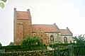
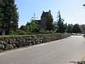
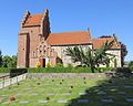
church building in Allerød Municipality, Denmark  | |||||
| Upload media | |||||
| Instance of | |||||
|---|---|---|---|---|---|
| Location | Blovstrød, Allerød Municipality, Capital Region of Denmark, Denmark | ||||
| Street address |
| ||||
| Diocese | |||||
| Religion or worldview | |||||
| official website | |||||
 | |||||
Dansk: Blovstrød Kirke, Allerød Kommune i Danmark
Subcategories
This category has only the following subcategory.
I
- Interior of Blovstrød Kirke (4 F)
Media in category "Blovstrød Kirke"
The following 9 files are in this category, out of 9 total.
-
 04-11-13-b2-copie 2 Blovstrød (Allerød).jpg 839 × 646; 292 KB
-
 04-11-13-b4-copie 2 Blovstrød (Allerød).jpg 834 × 638; 305 KB
-
 BlovstroedKirke.jpg 2,344 × 1,536; 787 KB
-
 Blovstrød - church.jpg 5,184 × 3,888; 6.91 MB
-
 Blovstrød Kirke 01.jpg 4,128 × 3,307; 3.15 MB
-
 Blovstrød Kirke 02.jpg 3,697 × 3,441; 3.01 MB
-
 Blovstrød Kirke 03.jpg 4,853 × 3,639; 4.42 MB
-
 Blovstrød Kirke 21-09-06 01.jpg 2,272 × 1,704; 1.85 MB
-
 DK Alleröd Blovströd kirke IMG 5709.jpg 3,456 × 2,304; 3.95 MB
.jpg)
.jpg)


