Category:Block diagrams (cartography)
Jump to navigation
Jump to search
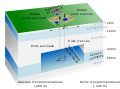
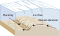
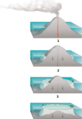
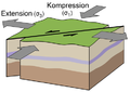
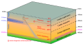
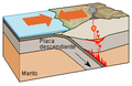
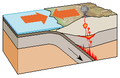
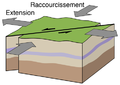
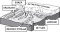
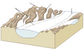
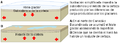
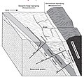
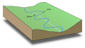
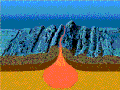
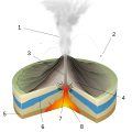
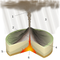
English: Block diagrams – also called Three-dimensional maps – are used to illustrate the geomorphology of a particular area or of a type of landform. They can be described as perspective drawings of relief models. (Monkhouse, Wilkinson: Maps and Diagrams. 3rd ed. 1971, p. 175)
Subcategories
This category has the following 5 subcategories, out of 5 total.
Media in category "Block diagrams (cartography)"
The following 200 files are in this category, out of 274 total.
(previous page) (next page)-
 Active Margin ka.svg 305 × 171; 52 KB
-
 Active Margin-bn.svg 305 × 171; 55 KB
-
 Active Margin-kn.svg 305 × 171; 54 KB
-
 Active Margin-mr.svg 305 × 171; 50 KB
-
 Active Margin-te.svg 305 × 171; 51 KB
-
 Active Margin.svg 512 × 287; 49 KB
-
 Aggradation.png 1,700 × 1,700; 69 KB
-
 Aggradation.svg 600 × 600; 509 KB
-
 Alluvions-fr.svg 1,789 × 1,311; 2 KB
-
 Alluvions-ru.svg 1,789 × 1,311; 2 KB
-
 Alluvions.png 723 × 522; 65 KB
-
 Amotoki CaseHardening 4 Pseudobomb.jpg 913 × 412; 82 KB
-
 ANDRA bloc laboratoire-2004-09.svg 1,017 × 758; 63 KB
-
 Anticline trap.svg 800 × 420; 8 KB
-
 Arranque glaciar as.svg 515 × 308; 100 KB
-
 Arranque glaciar-bn.svg 515 × 308; 100 KB
-
 Arranque glaciar-en-mr.svg 515 × 308; 101 KB
-
 Arranque glaciar-en.svg 515 × 308; 100 KB
-
 Arranque glaciar-kn.svg 483 × 289; 91 KB
-
 Arranque glaciar-lnf.svg 515 × 308; 100 KB
-
 Arranque glaciar-ml.svg 515 × 308; 100 KB
-
 Arranque glaciar-te.svg 515 × 308; 101 KB
-
 Atoll forming-Atoll.png 263 × 95; 30 KB
-
 Atoll forming-Barrier reef.png 263 × 102; 33 KB
-
 Atoll forming-Fringing reef.png 264 × 117; 33 KB
-
 Atoll forming-i18.png 1,667 × 2,423; 486 KB
-
 Atoll forming-volcano.png 263 × 194; 44 KB
-
 Atoll forming.jpg 283 × 503; 21 KB
-
 Benioff zone PL.png 264 × 176; 9 KB
-
 Benioff zone.PNG 264 × 176; 9 KB
-
 Blattverschiebung einschl. Spannungsvektoren.png 450 × 320; 46 KB
-
 Bloc diagramme Lias Haut Atlas.jpg 678 × 562; 102 KB
-
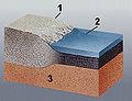
 Block diagram continental crust structure FR.svg 2,774 × 1,527; 164 KB
-
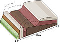
 Block diagrams stratigraphic relations.jpg 3,720 × 1,359; 687 KB
-
 Borde convergente.png 274 × 178; 9 KB
-
 Bordo convergente.png 274 × 178; 9 KB
-
 Briançonnais modèles 7F.jpg 1,677 × 1,896; 385 KB
-
 Buzul aşınması.png 314 × 192; 11 KB
-
 Buzul yeryüzü şekilleri.png 388 × 230; 36 KB
-
 Cabalgamiento-ventana-isla.png 800 × 331; 64 KB
-
 Cambrian substrate revolution 02.png 364 × 265; 61 KB
-
 Capa que buza río abajo con menor ángulo que el gradiente del valle.png 996 × 476; 110 KB
-
 Capa que buza río abajo.png 976 × 476; 110 KB
-
 Capa que buza río arriba.png 979 × 476; 104 KB
-
 Capa valle con la misma inclinación.png 997 × 476; 110 KB
-
 Capa vertical.png 979 × 476; 90 KB
-
 Cascadia earthquake sources.png 580 × 575; 25 KB
-
 Ciclo hidrológico da água.png 1,175 × 729; 220 KB
-
 Cinder cone heb.jpg 244 × 236; 16 KB
-
 Cinder cone lmb.png 244 × 236; 50 KB
-
 Cross-cutting relations.svg 1,000 × 540; 1.09 MB
-
 Denali National Park tectonic history.png 577 × 791; 193 KB
-
 Die Gartenlaube (1858) b 208 3.jpg 779 × 438; 69 KB
-
 Divergent border lmb.png 195 × 130; 18 KB
-
 Drumlins Lmb.png 249 × 109; 12 KB
-
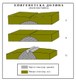 Epigenetska dolina.svg 522 × 565; 47 KB
-
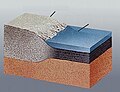 Erdekruste ohne Namen.jpg 366 × 281; 55 KB
-
 Erdkruste eo.jpg 830 × 562; 111 KB
-
 Erdkruste-i.jpg 366 × 281; 63 KB
-
 Erdkruste-i.png 366 × 281; 164 KB
-
 Evolution of the Chiricahua Landscape.jpg 1,473 × 1,563; 449 KB
-
 FailleDecrochement.png 450 × 320; 46 KB
-
 FailleNorm.png 420 × 320; 39 KB
-
 FaillInv.png 420 × 320; 44 KB
-
 Falde alpine.png 945 × 519; 25 KB
-
 Falde alpine.svg 945 × 500; 47 KB
-
 Falla de desp horiz lmb.png 300 × 174; 18 KB
-
 Falla inversa lmb.png 274 × 161; 16 KB
-
 Falla normal lmb.png 281 × 170; 17 KB
-
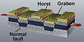
 Fault-Horst-Graben-ar.svg 534 × 274; 19 KB
-
 Fault-Horst-Graben-sv.svg 534 × 274; 20 KB
-
 Fault-Horst-Graben.svg 534 × 274; 18 KB
-
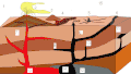
 Features of Subduction Zones.tif 2,760 × 2,282; 18.04 MB
-
 Fig 44 Schematic diagram.jpg 1,306 × 1,783; 232 KB
-
 FK1LMB.jpg 293 × 258; 30 KB
-
 FK2LMB.jpg 248 × 178; 25 KB
-
 FK3LMB.jpg 221 × 207; 22 KB
-
 Flank & hinge.PNG 1,019 × 823; 359 KB
-
 Floridan block diagram.png 761 × 465; 531 KB
-
 Flowerstructure1.png 934 × 539; 84 KB
-
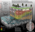 Geologic Section of USTs and Monitoring Wells.png 845 × 768; 1.08 MB
-
 Gerilemis buzul cephesi.png 442 × 214; 39 KB
-
 Geyser diagram lmb.png 274 × 457; 39 KB
-
 Glacial Compact.pdf 1,047 × 600; 113 KB
-
 Glacial Features.pdf 1,210 × 650; 121 KB
-
 Glacial landscape FR.PNG 388 × 230; 37 KB
-
 Glacial landscape LMB (no text).png 388 × 230; 43 KB
-
 Glacial landscape LMB.png 388 × 230; 38 KB
-
 Glacial landscape-sr.svg 388 × 230; 70 KB
-
 Glacial landscape.svg 388 × 230; 70 KB
-
 Glacier weight effects LMB (no text).png 482 × 174; 9 KB
-
 Glacier weight effects Lmb-pt.svg 482 × 174; 13 KB
-
 Glacier weight effects LMB.png 482 × 174; 11 KB
-
 Glacier weight effects Lmb.png 482 × 174; 12 KB
-
 GlazSerie1klein.jpg 1,421 × 915; 522 KB
-
 GlazSerie2klein.jpg 1,422 × 937; 555 KB
-
 Gletscherspuren.png 2,297 × 1,136; 189 KB
-
 Gogebic Range.jpg 608 × 561; 185 KB
-
 Graben Horst.png 346 × 276; 72 KB
-
 Grafik Donauversickerung.png 1,169 × 854; 116 KB
-
 Grand Staircase Stratigraphic Units.tif 3,193 × 1,869; 17.1 MB
-
 GraphCoastalStructuresScotland.gif 414 × 487; 86 KB
-
 Groundwater (aquifer, aquitard, 3 type wells).PNG 1,000 × 680; 71 KB
-
 Groundwater flow NL.svg 645 × 400; 226 KB
-
 Groundwater flow.svg 645 × 400; 86 KB
-
 Hadrosaur tracks.png 1,810 × 1,201; 929 KB
-
 Hawaiian Eruption-blank.svg 1,100 × 1,100; 113 KB
-
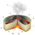 Hawaiian Eruption-numbers.svg 1,100 × 1,100; 123 KB
-
 Hawaiian Eruption-simplified pl.svg 880 × 987; 123 KB
-
 Horst graben.jpg 271 × 135; 41 KB
-
 Horst slenk.jpg 271 × 135; 11 KB
-
 Hoạt động mácma.gif 512 × 288; 25 KB
-
 Htyu.jpg 291 × 173; 9 KB
-
 Hydrologic cycle.png 535 × 349; 94 KB
-
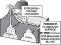
 Igneous structures.jpg 1,445 × 835; 347 KB
-
 Infiltration.jpg 550 × 418; 166 KB
-
 Intrusion types PL.svg 1,595 × 1,263; 72 KB
-
 Intrusion types.svg 1,180 × 1,263; 72 KB
-
 Intrusive-Extrusive Igneous Features.pdf 1,085 × 802; 89 KB
-
 Island arc.svg 1,404 × 2,219; 61 KB
-
 KarstterrainUSGS.jpg 1,313 × 585; 273 KB
-
 Kerghynedhow godhosek.jpg 1,280 × 720; 131 KB
-
 Largest eruptions-ru.svg 1,236 × 1,155; 625 KB
-
 Lewis overthrust fault nh10f.jpg 1,400 × 870; 71 KB
-
 Litosfera em margem ativa.svg 512 × 253; 20 KB
-
 Magma Chambers.jpg 1,200 × 1,121; 136 KB
-
 Main depositional environments th.svg 1,230 × 777; 548 KB
-
 Main depositional environments.svg 1,230 × 777; 603 KB
-
 Marine Terrace diagram(plain svg).svg 1,122 × 794; 104 KB
-
 Marine Terrace diagram.png 1,052 × 744; 102 KB
-
 Mastin2 lakesA.gif 500 × 391; 62 KB
-
 Meander multilangual.svg 500 × 258; 7 KB
-
 Meander-as.svg 500 × 280; 4 KB
-
 Meander-bn.svg 500 × 280; 4 KB
-
 Meander-cs.svg 500 × 280; 4 KB
-
 Meander-dty.svg 500 × 280; 6 KB
-
 Meander-en.svg 500 × 280; 4 KB
-
 Meander-hu.svg 500 × 258; 4 KB
-
 Meander-ml.svg 667 × 373; 53 KB
-
 Meander-ne.svg 500 × 280; 5 KB
-
 Meander-or.svg 500 × 280; 4 KB
-
 Meander-ro.svg 500 × 280; 4 KB
-
 Meander-sco.svg 500 × 280; 5 KB
-
 Mid-ocean ridge topography.gif 240 × 180; 1.06 MB
-
 MSJ.en.svg 1,015 × 785; 140 KB
-
 MSJ.fin.svg 1,024 × 740; 371 KB
-
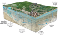
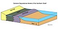 Northern Shelf Depositional Model.jpg 3,600 × 1,789; 475 KB
-
 NPS lassen-volcanic-bumpass-hell-map.jpg 3,228 × 2,020; 931 KB
-
 Oceanic-continental convergence Fig21oceancont (dumb version).png 450 × 265; 344 KB
-
 Oceanic-continental convergence Fig21oceancont.gif 302 × 178; 14 KB
-
 Oceanic-continental convergence.svg 710 × 417; 375 KB
-
 Ontstaan ijzeroerbank.PNG 1,091 × 638; 39 KB
-
 Ophiolite Formation.pdf 1,127 × 764; 207 KB
-
 Overschuiving systeem.jpg 3,828 × 1,583; 294 KB
-
 Paisaje glaciar Lmb.png 388 × 230; 48 KB
-
 Paysage glaciaire.png 388 × 230; 37 KB
-
 Pelean Eruption-blank.svg 1,100 × 1,100; 274 KB
-
 Pelean Eruption-numbers batik.png 1,100 × 1,100; 731 KB
-
 Pelean Eruption-numbers Inkscape.png 1,100 × 1,100; 740 KB
-
 Pelean Eruption-numbers librsvg.png 1,100 × 1,100; 734 KB
-
 Pelean Eruption-numbers rendersvg.png 1,100 × 1,100; 928 KB
-
 Pelean Eruption-numbers.svg 1,100 × 1,100; 276 KB
-
 Philippine-reef-block hg.png 3,800 × 2,844; 3.51 MB
-
 Phreatic Eruption-blank.svg 1,100 × 1,100; 152 KB
-
 Phreatic Eruption-numbers batik.png 1,100 × 1,100; 353 KB
-
 Phreatic Eruption-numbers Inkscape.png 1,100 × 1,100; 397 KB
-
 Phreatic Eruption-numbers librsvg.png 1,100 × 1,100; 395 KB
-
 Phreatic Eruption-numbers rendersvg.png 1,100 × 1,100; 502 KB
-
 Phreatic Eruption-numbers.svg 1,100 × 1,100; 86 KB
-
 Phreatomagmatic Eruption-blank.svg 1,100 × 1,100; 168 KB
-
 Phreatomagmatic Eruption-numbers.svg 1,100 × 1,100; 175 KB
-
 Plec.JPG 1,438 × 969; 86 KB
-
 Plinian Eruption-blank.svg 1,100 × 1,100; 154 KB
-
 Plinian Eruption-fa.svg 1,100 × 1,100; 159 KB
-
 Plinian Eruption-numbers.svg 1,100 × 1,100; 158 KB
-
 Plinien (volcano).svg 1,290 × 1,575; 53 KB
-
 Plucking LMB (no text).png 314 × 192; 11 KB
-
 Pop-up & Pop-down structures EN.svg 534 × 274; 33 KB
-
 Principales medios sedimentarios.svg 1,230 × 777; 603 KB
-
 Prisma de acrecion lmb rg.jpg 264 × 167; 45 KB
-
 Prisma de acrecion lmb.png 264 × 167; 9 KB
-
 Receding glacier landscape LMB (no text).png 442 × 214; 39 KB
-
 Receding glacier landscape LMB.png 442 × 214; 38 KB
-
 Receding glacier with numbers.svg 1,200 × 562; 353 KB
-
 Receding glacier-da.svg 1,200 × 562; 352 KB
-
 Receding glacier-en.svg 1,200 × 562; 260 KB
-
 Reelfoot Rift diagram from USGS en.svg 426 × 287; 606 KB
-
 Representing three-dimensional map information.jpg 450 × 601; 40 KB
-
 Retroceso Glaciar Lmb.png 442 × 214; 42 KB
-
 Ridge render heb.jpg 1,041 × 617; 53 KB
-
 Ridge render ru.jpg 350 × 179; 12 KB
-
 Ridge render-ja.jpg 350 × 179; 23 KB
-
 Ridge render.jpg 350 × 179; 12 KB
-
 Rock shelter formation by frost weathering.svg 1,700 × 1,180; 28 KB
-
 Rock shelter formation by karst gallery cutting.svg 2,400 × 740; 48 KB
-
 Rock shelter formation by river erosion.svg 3,660 × 1,050; 54 KB
-
 SedimentaryEnvironment.jpg 1,400 × 1,050; 132 KB
-
 Selected karst features.svg 1,420 × 1,162; 511 KB
-
 Shield volcano lmb.png 275 × 200; 28 KB
-
 Sial ve sima.jpg 350 × 247; 51 KB


_b_208_3.jpg)


.png)


.PNG)


.svg)


.png)


.svg)
.png)


.png)


&filefrom=Sierra+Fault+Block.gif#mw-category-media)
.png)