Category:Blidsbergs kyrka
Jump to navigation
Jump to search
| Object location | | View all coordinates using: OpenStreetMap |
|---|
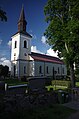
church building in Ulricehamn Municipality, Västra Götaland County, Sweden   | |||||
| Upload media | |||||
| Instance of | |||||
|---|---|---|---|---|---|
| Location | Ulricehamn Municipality, Västra Götaland County, Sweden | ||||
| Diocese | |||||
| Has use |
| ||||
| Occupant | |||||
| Heritage designation |
| ||||
 | |||||
Svenska: Blidsbergs kyrka tillhör Redvägs församling i Skara stift i Ulricehamns kommun.
|
This is a category about an ecclesiastical monument in Sweden, number 21300000003205 (sub-number: 21400000443848) in the RAÄ buildings database.
|
Subcategories
This category has the following 3 subcategories, out of 3 total.
- Interior of Blidsbergs kyrka (34 F)
V
Media in category "Blidsbergs kyrka"
The following 19 files are in this category, out of 19 total.
-
 Blidsbergs kyrka - KMB - 16000200152427.jpg 824 × 600; 49 KB
-
 Blidsbergs kyrka - KMB - 16000200152428.jpg 830 × 600; 69 KB
-
 Blidsbergs kyrka - KMB - 16000200152431.jpg 434 × 600; 83 KB
-
 Blidsbergs kyrka - KMB - 16000200152432.jpg 465 × 600; 86 KB
-
 Blidsbergs kyrka - KMB - 16000200152434.jpg 452 × 600; 62 KB
-
 Blidsbergs kyrka - KMB - 16000200152440.jpg 438 × 600; 53 KB
-
 Blidsbergs kyrka - KMB - 16000200152443.jpg 859 × 600; 117 KB
-
 Blidsbergs kyrka - KMB - 16000200152446.jpg 853 × 600; 145 KB
-
 Blidsbergs kyrka - KMB - 16000200152451.jpg 850 × 600; 143 KB
-
 Blidsbergs kyrka - KMB - 16000200152486.jpg 439 × 600; 88 KB
-
 Blidsbergs kyrka - panoramio.jpg 800 × 600; 387 KB
-
 Blidsbergs kyrka 01.jpg 3,264 × 4,928; 1.95 MB
-
 Blidsbergs kyrka 02.jpg 3,264 × 4,928; 1.92 MB
-
 Blidsbergs kyrka 03.jpg 3,256 × 4,143; 1.94 MB
-
 Blidsbergs kyrka 06.jpg 3,264 × 4,928; 1.95 MB
-
 Blidsbergs kyrka.JPG 3,147 × 2,106; 3.91 MB
-
 Blidsbergs kyrka - KMB - 16000200152492.jpg 857 × 600; 124 KB
-
 Blidsbergs kyrka - KMB - 16000200152489.jpg 426 × 600; 39 KB
-
 Blidsbergs kyrka - KMB - 16000200152487.jpg 423 × 600; 58 KB


Categories:
- Abraham Ludvig Hedin
- Buildings in Blidsberg
- Built in Ulricehamn Municipality in 1869
- Churches in the Diocese of Skara
- Stone churches in Ulricehamn Municipality
- Churches in Västergötland
- Churches in Västra Götaland County built in 1869
- Listed churches in Ulricehamn Municipality
- Neoclassical churches in Västra Götaland County
- White churches in Sweden