Category:Blauwhuis cemetery
Jump to navigation
Jump to search
| Object location | | View all coordinates using: OpenStreetMap |
|---|
| Upload media | |||||
| Instance of | |||||
|---|---|---|---|---|---|
| Part of | |||||
| Location | Blauwhuis, Súdwest-Fryslân, Friesland, Netherlands | ||||
| Heritage designation |
| ||||
 | |||||
Nederlands: Sint-Vituskerk, begraafplaats
|
This is a category about rijksmonument number 515170
|
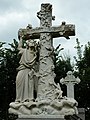
Nederlands: Sint-Vituskerk, begraafplaats: calvariegroep
|
This is a category about rijksmonument number 515171
|
Nederlands: Sint-Vituskerk, begraafplaats: piëta-grafmonument voor pastoor G.J. Evers
|
This is a category about rijksmonument number 515172
|
Nederlands: Sint-Vituskerk, begraafplaats: grafmonument met kruis en engel voor Ydema-Witteveen
|
This is a category about rijksmonument number 515173
|
Nederlands: Sint-Vituskerk, begraafplaats: baarhuis
|
This is a category about rijksmonument number 515174
|
| Address |
|
Media in category "Blauwhuis cemetery"
The following 6 files are in this category, out of 6 total.
-
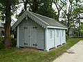 Blauwhuis - Baarhuisje 2022.jpg 4,000 × 3,000; 5.03 MB
-
 Blauwhuis - Baarhuisje.jpg 4,000 × 3,000; 5.05 MB
-
 Blauwhuis - Calvariegroep.jpg 3,000 × 4,000; 4.04 MB
-
 Blauwhuis - Grafmonument met engel en stammenkruis.jpg 3,000 × 4,000; 3.96 MB
-
 Blauwhuis - Piëta grafmonument voor pastoor Evers.jpg 3,000 × 4,000; 4.28 MB
-
 Foto uit kikkerperspectief van het R, SFA002003332.jpg 3,427 × 2,022; 827 KB


