Category:Bezirksgebäude Baden
Jump to navigation
Jump to search
| Object location | | View all coordinates using: OpenStreetMap |
|---|
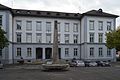
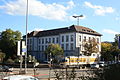
administrative building in Baden in the canton of Aargau, Switzerland  | |||||
| Upload media | |||||
| Instance of | |||||
|---|---|---|---|---|---|
| Part of | |||||
| Location | Baden, Baden District, Aargau, Switzerland | ||||
| Street address |
| ||||
| Heritage designation | |||||
 | |||||
Media in category "Bezirksgebäude Baden"
The following 4 files are in this category, out of 4 total.
-
 Baden Bezirksgebaeude mit Obeliskbrunnen 20130930.jpg 4,653 × 3,117; 7.26 MB
-
 Baden, Aargau, Bezirksgebäude, 2013.jpg 4,928 × 3,264; 4.1 MB
-
 Baden, Aargau, Bezirksgebäude, Luftbild.jpg 2,000 × 1,500; 783 KB
-
 Schulhausplatz Baden 2013-10-17 14.52.37.jpg 3,888 × 2,592; 3.57 MB


