Category:Beundenfeld (Bern)
Jump to navigation
Jump to search
| Object location | | View all coordinates using: OpenStreetMap |
|---|
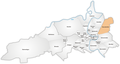
Deutsch: Beundenfeld ist ein Quartier, respektive "Statistischer Bezirk", im Stadtteil Kirchenfeld-Schosshalde, der auch als Stadtteil IV bekannt ist, in der Stadt Bern in der Schweiz. Siehe auch Grenzen Beundenfeldquartier auf OSM
quarter/"statistical district", in the district Kirchenfeld-Schosshalde/quarter IV in the city of Bern, Switzerland  | |||||
| Upload media | |||||
| Instance of |
| ||||
|---|---|---|---|---|---|
| Part of | |||||
| Location | Kirchenfeld-Schosshalde, Bern, Bern-Mittelland administrative district, Bernese Mittelland administrative region, Bern, Switzerland | ||||
 | |||||
Subcategories
This category has the following 8 subcategories, out of 8 total.
Media in category "Beundenfeld (Bern)"
The following 2 files are in this category, out of 2 total.
-
 A6 Bern-Wankdorf, map OSM 2022.png 551 × 779; 228 KB
-
 Karte Berner Quartiere Beundenfeld.png 1,476 × 793; 277 KB
