Category:Bellevue - Chantenay - Sainte-Anne (quartier de Nantes)
Jump to navigation
Jump to search
| Object location | | View all coordinates using: OpenStreetMap |
|---|
| Upload media | |||||
| Instance of |
| ||||
|---|---|---|---|---|---|
| Location | Nantes, Loire-Atlantique, Pays de la Loire, Metropolitan France, France | ||||
 | |||||
Subcategories
This category has the following 22 subcategories, out of 22 total.
2
A
- Rue Alexandre-Ribot (Nantes) (2 F)
- Rue Alexis-Grassin (Nantes) (2 F)
B
- Rue Bisson (Nantes) (2 F)
- Rue du Bois-Hercé (4 F)
C
D
- Rue Durance (3 F)
G
- Grue noire (5 F)
H
P
- Rue Pierre-Dupont (Nantes) (2 F)
Q
- Quai Ernest-Renaud (9 F)
R
- Route de Roche-Maurice (3 F)
- Rue du Roi-Baco (2 F)
- Rue des Roquios (Nantes) (3 F)
S
- Rue des Salorges (Nantes) (3 F)
- Square Maurice-Schwob (1 P, 13 F)
Media in category "Bellevue - Chantenay - Sainte-Anne (quartier de Nantes)"
The following 57 files are in this category, out of 57 total.
-
 Plaque Rue du 4 Août 1789.jpg 4,000 × 3,000; 1.03 MB
-
 Plaque Rue du 4 Septembre 1870.jpg 4,000 × 3,000; 836 KB
-
 Plaque Rue de l'Abbaye.jpg 4,000 × 3,000; 3.16 MB
-
 Plaque Rue Amiral Jean Minot.jpg 4,000 × 3,000; 1.7 MB
-
 Ancienne plaque Rue Pierre Dupont.jpg 4,000 × 3,000; 2.24 MB
-
 Plaque Rue André Hougron.jpg 4,000 × 3,000; 2.9 MB
-
 Plaque Rue Antoine Noisette, Nantes.jpg 4,000 × 3,000; 2.71 MB
-
 Plaque Boulevard de la Liberté.jpg 4,000 × 3,000; 614 KB
-
 Plaque Chemin des Vignes du Bourg.jpg 4,000 × 3,000; 418 KB
-
 Plaque Chemin du Bois-de-Hercé.jpg 4,000 × 3,000; 1.15 MB
-
 Plaque Chemin Poisson.jpg 4,000 × 3,000; 1.56 MB
-
 Plaque Impasse Le Bigot.jpg 4,000 × 3,000; 725 KB
-
 Plaque Place de la Nation.jpg 4,000 × 3,000; 812 KB
-
 Plaque Place du Bourg.jpg 4,000 × 3,000; 1.12 MB
-
 Plaque Place Jean Macé.jpg 4,000 × 3,000; 1.21 MB
-
 Plaque Promenade des Nefs.jpg 4,000 × 3,000; 1.47 MB
-
 Plaque Rue de l'Ouche Cormier.jpg 4,000 × 3,000; 3.49 MB
-
 Plaque Rue de la Cure.jpg 4,000 × 3,000; 1.47 MB
-
 Plaque Rue de la Fédération.jpg 4,000 × 3,000; 1.2 MB
-
 Plaque Rue de la Hérelle.jpg 4,000 × 3,000; 1.79 MB
-
 Plaque Rue de la Marseillaise.jpg 4,000 × 3,000; 692 KB
-
 Plaque Rue de la Tannerie.jpg 4,000 × 3,000; 534 KB
-
 Plaque Rue de Thoiry.jpg 4,000 × 3,000; 2.38 MB
-
 Plaque Rue de Tréméac.jpg 4,000 × 3,000; 2.06 MB
-
 Plaque Rue des Civelles.jpg 4,000 × 3,000; 293 KB
-
 Plaque Rue des Courtils.jpg 4,000 × 3,000; 2.14 MB
-
 Plaque Rue des Droits de l'Homme.jpg 4,000 × 3,000; 342 KB
-
 Plaque Rue des Girondins.jpg 4,000 × 3,000; 2.88 MB
-
 Plaque Rue des Réformes.jpg 4,000 × 3,000; 2.75 MB
-
 Plaque Rue Docteur Paul Macé.jpg 4,000 × 3,000; 1.64 MB
-
 Plaque Rue du Bois Haligan.jpg 4,000 × 3,000; 1.14 MB
-
 Plaque Rue du Fonteny.jpg 4,000 × 3,000; 1.41 MB
-
 Plaque Rue Eugène Le Roux.jpg 4,000 × 3,000; 1.42 MB
-
 Plaque Rue Guillard.jpg 4,000 × 3,000; 1.32 MB
-
 Plaque Rue Général de Wet.jpg 4,000 × 3,000; 2.05 MB
-
 Plaque Rue Henri Billot.jpg 4,000 × 3,000; 978 KB
-
 Plaque Rue Kruger.jpg 4,000 × 3,000; 397 KB
-
 Plaque Rue Louis Guilloux.jpg 4,000 × 3,000; 2.15 MB
-
 Plaque Rue Maurice Barlier.jpg 4,000 × 3,000; 2.6 MB
-
 Plaque Rue Maurice Terrien.jpg 4,000 × 3,000; 389 KB
-
 Plaque Rue Paul Griveaud.jpg 4,000 × 3,000; 691 KB
-
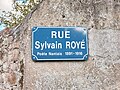 Plaque Rue Sylvain Royé.jpg 4,000 × 3,000; 3 MB
-
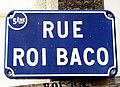 Rue du Roi-Baco (Nantes) 02.jpg 3,918 × 2,842; 1.84 MB
-
 W3142 Nantes Chantenay 15855.jpg 5,984 × 3,376; 13.36 MB
-
 W3143Nantes Chantenay 15856.jpg 5,984 × 3,376; 12.5 MB
-
 W3144 Nantes Chantenay 15860.jpg 5,984 × 3,376; 11.47 MB
-
 W3145 Nantes Chantenay 15862.jpg 5,984 × 3,376; 10.6 MB
-
 W3146 Nantes Chantenay 15863.jpg 5,984 × 3,376; 12.91 MB
-
 W3147 Nantes Chantenay 15861.jpg 5,984 × 3,376; 9.07 MB
-
 W3148 Nantes Chantenay 15857.jpg 5,984 × 3,376; 8.3 MB
-
 W3149 Nantes Chantenay 15859.jpg 5,984 × 3,376; 7.96 MB
-
 W3150 Nantes Chantenay 15869.jpg 5,984 × 3,376; 11.05 MB
-
 W3151 Nantes Chantenay 15867.jpg 5,984 × 3,376; 9 MB
-
 W3152 Nantes Chantenay 15870.jpg 5,984 × 3,376; 8.03 MB
-
 W3153 Nantes Chantenay 15918.jpg 5,984 × 3,376; 7.44 MB
-
 W3154 Nantes Chantenay 15922.jpg 5,984 × 3,376; 8.02 MB
-
 W3156 Nantes Navibus IleDeNantes 15928.jpg 5,984 × 3,376; 7.19 MB


_02.jpg)


