Category:Bell Rock Lighthouse
Jump to navigation
Jump to search
| Object location | | View all coordinates using: OpenStreetMap |
|---|
|
This is a category about listed building number 45197. |
English: Bell Rock Lighthouse
lighthouse off the coast of Angus, Scotland, UK  Bell Rock Lighthouse with reef just visible   | |||||
| Upload media | |||||
| Instance of | |||||
|---|---|---|---|---|---|
| Made from material |
| ||||
| Location | |||||
| Architect | |||||
| Main building contractor | |||||
| Operator | |||||
| Heritage designation |
| ||||
| Service entry |
| ||||
| Inception |
| ||||
| Significant event |
| ||||
| Height |
| ||||
 | |||||
Subcategories
This category has the following 2 subcategories, out of 2 total.
S
- Signal Tower, Arbroath (30 F)
Media in category "Bell Rock Lighthouse"
The following 36 files are in this category, out of 36 total.
-
 British Rock Lighthouses.jpg 1,902 × 1,205; 673 KB
-
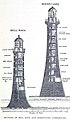 Bell Rock and Skerryvore Lighthouses.jpg 1,028 × 1,712; 578 KB
-
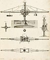
 Apparatus connected with the Bell Rock works engraving by William Miller after G Scott.jpg 3,307 × 2,240; 1.93 MB
-
 Balance Crane.jpg 1,014 × 1,200; 114 KB
-
 Bell Rock from Arbroath - geograph.org.uk - 2005705.jpg 800 × 533; 171 KB
-
 Bell Rock Light - geograph.org.uk - 361587.jpg 640 × 426; 61 KB
-

-

-

-
 Bell Rock Lighthouse .PNG 1,151 × 764; 1.66 MB
-
 Bell Rock Lighthouse 01.jpg 640 × 640; 64 KB
-
 Bell Rock Lighthouse cross section.JPG 407 × 538; 21 KB
-
 Bell Rock Lighthouse during a storm cph.3b18344.jpg 1,357 × 908; 267 KB
-
 Bell Rock Lighthouse Library (Ballantyne, 1865).jpg 2,534 × 2,160; 1.23 MB
-
 Bell Rock lighthouse model.JPG 2,832 × 4,256; 2.12 MB
-
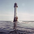
 Bell Rock Lighthouse showing reef (cropped).jpg 1,127 × 1,510; 648 KB
-
 Bell Rock Lighthouse showing reef.jpg 4,000 × 3,000; 4.34 MB
-
 Bell Rock Lighthouse. Base construction detail.png 350 × 339; 54 KB
-
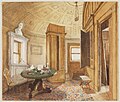
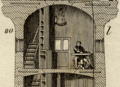 Bell Rock Lighthouse. Last room.png 496 × 360; 114 KB
-
 Bell Rock Lighthouse. Original optics.JPG 593 × 357; 24 KB
-
 Bell rock lighthouse. Roofs detail.JPG 584 × 335; 30 KB
-
 Bell Rock Lighthouse.jpg 497 × 560; 156 KB
-
 BellRock-CEAJ.jpg 1,214 × 888; 257 KB
-
 BellRock-construction.jpg 1,012 × 749; 221 KB
-
 Bellrock-lighthouse.jpg 800 × 600; 106 KB
-
 Bellrock.jpg 960 × 636; 39 KB
-
-

-

-
 FMIB 36815 Phare de Bell-Rock, en Ecosse, construit de 1807 a 1811.jpeg 813 × 1,127; 438 KB
-
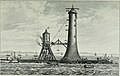
 General View of the Bell Rock Works engraving by William Miller after A Carse.jpg 3,297 × 2,274; 2.59 MB
-
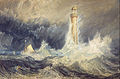 Joseph Mallord William Turner - Bell Rock Lighthouse - Google Art Project.jpg 4,001 × 2,640; 3.85 MB
-
 Progress of the Bell Rock Works engraving by William Miller after J Slight.jpg 3,217 × 2,198; 1.48 MB
-
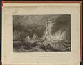 Stormy Weather.jpg 3,858 × 3,053; 17.1 MB
-

-


.jpg)

.jpg)


.jpg)


Categories:
- Lighthouses in Angus
- Built in Scotland in 1807
- Lighthouses built in 1807
- 1800s lighthouses in the United Kingdom
- Category A listed buildings in Angus
- Listed lighthouses in Scotland
- Lighthouses in Scotland by name
- Lighthouses built by Stevenson family
- Stone lighthouses in the United Kingdom
- Lighthouses by height, 31 to 40 meters
- Lighthouses on wave-washed rocks
- Listed buildings in Arbroath And St Vigeans, Angus
- Inchcape
- Lighthouses with hyperradiant Fresnel lenses
- Landfall lights in the United Kingdom
- Lighthouses by range, 15 to 19 nm