Category:Beetley
Jump to navigation
Jump to search
English: Beetley is a village and civil parish in the Breckland district of Norfolk, England. According to the 2001 census the parish had a population of 1,385. The village is situated four miles north of Toftwood.
a village located in Breckland District, United Kingdom | |||||
| Upload media | |||||
| Instance of | |||||
|---|---|---|---|---|---|
| Location | Breckland, Norfolk, East of England, England | ||||
| Area |
| ||||
 | |||||
Subcategories
This category has the following 4 subcategories, out of 4 total.
Media in category "Beetley"
The following 121 files are in this category, out of 121 total.
-
 19th Century Map of Beetley.png 863 × 554; 1.18 MB
-
 20th Century Map of Beetley.png 871 × 553; 1.02 MB
-
 A car park - geograph.org.uk - 607167.jpg 640 × 480; 105 KB
-
 B1146 entering East Bilney - geograph.org.uk - 5015192.jpg 2,011 × 1,279; 1.84 MB
-
 B1146 Fakenham Road - geograph.org.uk - 5015181.jpg 2,136 × 1,420; 1.86 MB
-
 Beetley Hall - geograph.org.uk - 6177548.jpg 6,376 × 4,250; 6.56 MB
-
 Beetley Hall Farm - geograph.org.uk - 6177550.jpg 7,090 × 4,726; 6.22 MB
-
 Beetley Hall Farm - geograph.org.uk - 6177552.jpg 6,970 × 4,646; 4.91 MB
-
 Beetley Methodist Chapel - geograph.org.uk - 6177882.jpg 6,419 × 4,279; 5.73 MB
-
 Beetley Methodist Chapel - geograph.org.uk - 6177883.jpg 5,718 × 3,812; 4.62 MB
-
 Beetley St Mary Magdalene's church - geograph.org.uk - 2230491.jpg 640 × 480; 80 KB
-
 Beetley, Drift Farm - geograph.org.uk - 6177877.jpg 6,350 × 4,234; 7.21 MB
-
 Beetley, Junction of Vale Road and Bittering Street - geograph.org.uk - 6177879.jpg 6,488 × 4,325; 6.05 MB
-
 Beetley, Signpost in High House Road - geograph.org.uk - 6177888.jpg 5,580 × 3,721; 5.6 MB
-
 Beetley, Two houses in High House Road - geograph.org.uk - 6177887.jpg 7,397 × 4,931; 7.09 MB
-
 Bends at East Bilney - geograph.org.uk - 5015204.jpg 2,024 × 1,311; 1.88 MB
-
 Bittering Road, Beetley - geograph.org.uk - 6286497.jpg 3,887 × 2,200; 1.21 MB
-
 Bittering, Nar Valley Way leading from Stoney Lane - geograph.org.uk - 6177379.jpg 5,982 × 3,989; 6.91 MB
-
 Clock - geograph.org.uk - 1242990.jpg 480 × 640; 70 KB
-
 Cows graze Hoe Rough - geograph.org.uk - 390936.jpg 640 × 480; 104 KB
-
 East Bilney Ford - geograph.org.uk - 2923152.jpg 3,872 × 2,592; 2.38 MB
-
 East Bilney St Mary's church - geograph.org.uk - 2230494.jpg 640 × 480; 148 KB
-
 East Bilney, St. Mary's Church - geograph.org.uk - 5672467.jpg 5,637 × 3,762; 5.62 MB
-
 East Bilney, St. Mary's Church, Carving in the south porch - geograph.org.uk - 5672472.jpg 5,968 × 3,983; 3.19 MB
-
 East Bilney, St. Mary's Church, southern aspect - geograph.org.uk - 5672475.jpg 6,268 × 4,183; 6.45 MB
-
 Fakenham Road - geograph.org.uk - 5015311.jpg 2,116 × 1,384; 1.52 MB
-
 Folly Lane - geograph.org.uk - 608043.jpg 480 × 640; 126 KB
-
 Grazing deer - geograph.org.uk - 383734.jpg 640 × 480; 77 KB
-
 Gressenhall Farm and Workhouse - geograph.org.uk - 358175.jpg 600 × 450; 52 KB
-

-
 Gressenhall, Cereal crop in Stoney Lane - geograph.org.uk - 6177864.jpg 6,503 × 4,335; 5.65 MB
-

-

-
 Gressenhall, Stoney Lane - geograph.org.uk - 6177855.jpg 6,443 × 4,295; 7.46 MB
-
 Gressenhall, The junction of Stoney Lane and Bilney Road - geograph.org.uk - 6177388.jpg 7,111 × 4,741; 7.35 MB
-
 Gressenhall, The junction of Stoney Lane and Bilney Road - geograph.org.uk - 6177400.jpg 6,086 × 4,057; 6.61 MB
-
 Gressenhall, Vale Farm - geograph.org.uk - 6177867.jpg 7,135 × 4,756; 7.72 MB
-
 Gressenhall, Vale Farm - geograph.org.uk - 6177869.jpg 6,893 × 4,595; 5.51 MB
-
 Gressenhall, Vale Farm - geograph.org.uk - 6177873.jpg 6,630 × 4,420; 6.35 MB
-
 Hall Road, Old Beetley - geograph.org.uk - 4562264.jpg 640 × 480; 168 KB
-
 High hedges hiding the quarry workings - geograph.org.uk - 4562261.jpg 640 × 480; 192 KB
-
 Hoe Common - geograph.org.uk - 333703.jpg 640 × 480; 90 KB
-
 Houses on Beech Road, Beetley - geograph.org.uk - 5540894.jpg 640 × 480; 63 KB
-

-
 Longham Lane - geograph.org.uk - 607191.jpg 480 × 640; 64 KB
-

-
 Methodist chapel - geograph.org.uk - 383747.jpg 640 × 480; 114 KB
-
 Old Beetley, Clark's Farm - geograph.org.uk - 6177891.jpg 6,873 × 4,582; 7.09 MB
-
 Old Beetley, Clark's Farm - geograph.org.uk - 6177893.jpg 6,425 × 4,283; 5.97 MB
-

-
 Old Beetley, Crops seen from Fishers Lane (track) - geograph.org.uk - 6177423.jpg 4,263 × 2,841; 1.9 MB
-
 Old Beetley, Drainage stream from Spong Bridge - geograph.org.uk - 6177573.jpg 4,797 × 3,198; 5.43 MB
-
 Old Beetley, Fishers Lane (track) - geograph.org.uk - 6177419.jpg 6,249 × 4,165; 7.4 MB
-
 Old Beetley, Peacock Farm - geograph.org.uk - 6177559.jpg 6,876 × 4,583; 6.79 MB
-
 Old Beetley, Spong Bridge - geograph.org.uk - 6177574.jpg 5,641 × 3,761; 6.35 MB
-

-

-
-
 Old Beetley, St. Mary Magdalene's Church, Southern aspect - geograph.org.uk - 6177410.jpg 7,164 × 4,775; 7.81 MB
-

-
 Old Beetley, St. Mary Magdalene's Church, Tower entrance - geograph.org.uk - 6177918.jpg 4,470 × 2,980; 3.98 MB
-
 Old Beetley, St. Mary Magdalene's Church, Western aspect - geograph.org.uk - 6177406.jpg 4,488 × 6,731; 7.59 MB
-
 Old Beetley, The junction of Hall Road and Dereham Road - geograph.org.uk - 6177556.jpg 6,976 × 4,651; 7.2 MB
-
 Old farm buildings at Hungry Hill - geograph.org.uk - 4562258.jpg 640 × 480; 150 KB
-
 Ordnance Survey Flush Bracket S9656 - geograph.org.uk - 4292423.jpg 4,000 × 3,000; 3.5 MB
-
 OS Flush Bracket S9656 - geograph.org.uk - 1900674.jpg 1,024 × 819; 248 KB
-
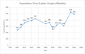 Population-Time Scatter Graph of Beetley.png 576 × 365; 14 KB
-

-

-
 Rusty gate at the start of a track - geograph.org.uk - 607863.jpg 640 × 480; 95 KB
-
 Scout Headquarters at Beetley - geograph.org.uk - 6286492.jpg 3,887 × 2,200; 1.62 MB
-
-
 Sustrans milepost - geograph.org.uk - 383737.jpg 480 × 640; 108 KB
-
 The River Cam, Beetley - geograph.org.uk - 5540897.jpg 480 × 640; 119 KB
-
 The westernmost section of Fishers Lane - geograph.org.uk - 607874.jpg 480 × 640; 105 KB
-
 Thelveton Mill Machinery - geograph.org.uk - 3065051.jpg 485 × 640; 282 KB
-
 Track beside Rawhall Wood - geograph.org.uk - 522848.jpg 480 × 640; 158 KB
-
 Village Sign - geograph.org.uk - 1242987.jpg 640 × 480; 88 KB
-
 Water troughs - geograph.org.uk - 1310158.jpg 640 × 480; 107 KB
-
 What is happening here^ (1) - geograph.org.uk - 608028.jpg 640 × 480; 56 KB
-
 What is happening here^ (2) - geograph.org.uk - 608038.jpg 480 × 640; 65 KB
-
 A digger at work - geograph.org.uk - 608019.jpg 640 × 480; 57 KB
-
 A lot of earth has been moved - geograph.org.uk - 608005.jpg 640 × 480; 83 KB
-
 A row of cottages on School Road - geograph.org.uk - 607939.jpg 640 × 480; 103 KB
-
 A topiary boat - geograph.org.uk - 607956.jpg 640 × 480; 70 KB
-
 Access into a field - geograph.org.uk - 607866.jpg 640 × 480; 87 KB
-
 Approach to Old Beetley - geograph.org.uk - 607963.jpg 640 × 480; 101 KB
-

-
 Between a hedge and a gate post - geograph.org.uk - 607974.jpg 480 × 640; 97 KB
-
 Blue toilet hut - geograph.org.uk - 608011.jpg 640 × 480; 56 KB
-
 Church Farm - geograph.org.uk - 607948.jpg 640 × 480; 97 KB
-
 Coppiced hazel tree - geograph.org.uk - 607882.jpg 480 × 640; 137 KB
-
 Coppiced tree in hedgerow - geograph.org.uk - 607884.jpg 480 × 640; 131 KB
-
 Cottages in Hoe - geograph.org.uk - 396593.jpg 600 × 450; 88 KB
-
 Fishers Lane - geograph.org.uk - 607710.jpg 480 × 640; 95 KB
-
 Fishers Lane meets unnamed track - geograph.org.uk - 607726.jpg 640 × 480; 84 KB
-

-
 Footpath near Church Farm - geograph.org.uk - 607946.jpg 480 × 640; 182 KB
-
 Gate with a view - geograph.org.uk - 607971.jpg 480 × 640; 48 KB
-
 Gorgate Road - geograph.org.uk - 607065.jpg 480 × 640; 110 KB
-
 Hedge displaying autumn colours - geograph.org.uk - 607836.jpg 640 × 480; 108 KB
-
 Land-fill site north of School Road - geograph.org.uk - 607991.jpg 640 × 480; 65 KB
-
 Landscaping in progress - geograph.org.uk - 608023.jpg 640 × 480; 56 KB
-
 Lane to "The Nursery", Hoe. - geograph.org.uk - 396584.jpg 600 × 450; 99 KB
-
 Looking southwest - geograph.org.uk - 607870.jpg 640 × 480; 101 KB
-
 Looking west on School Road - geograph.org.uk - 607733.jpg 480 × 640; 104 KB
-
 Mounds of earth waiting to be shifted - geograph.org.uk - 608166.jpg 640 × 480; 121 KB
-
 Nar Valley Way - geograph.org.uk - 383729.jpg 480 × 640; 149 KB
-
 Notice at Hoe Rough - geograph.org.uk - 390953.jpg 640 × 480; 55 KB
-
 Pond reflections - geograph.org.uk - 607982.jpg 640 × 480; 151 KB
-
 Pool - geograph.org.uk - 383730.jpg 640 × 480; 224 KB
-
 Stile - geograph.org.uk - 383755.jpg 480 × 640; 151 KB
-
 Straw bales behind barbed wire fence - geograph.org.uk - 607867.jpg 640 × 480; 94 KB
-
 The Green - geograph.org.uk - 607936.jpg 480 × 640; 90 KB
-
 The mid-section of Fishers Lane - geograph.org.uk - 607883.jpg 480 × 640; 138 KB
-
 The River Whitewater - geograph.org.uk - 379773.jpg 600 × 450; 94 KB
-
 Track leading west - geograph.org.uk - 607718.jpg 480 × 640; 133 KB
-
 Tree - geograph.org.uk - 383752.jpg 640 × 480; 112 KB
-
 Union Farm, Gressenhall - geograph.org.uk - 379769.jpg 600 × 450; 66 KB
-
 Union Farm, Gressenhall - geograph.org.uk - 379772.jpg 600 × 450; 48 KB
-
 Warning notice - geograph.org.uk - 333701.jpg 640 × 480; 99 KB


_-_geograph.org.uk_-_6177423.jpg)

_-_geograph.org.uk_-_6177419.jpg)


,_Robertson_Barracks_and_disused_airfield_(aerial_2017)_-_geograph.org.uk_-_5525918.jpg)
,_Robertson_Barracks_and_disused_airfield_(aerial_2017)_-_geograph.org.uk_-_5525913.jpg)


_-_geograph.org.uk_-_608028.jpg)
_-_geograph.org.uk_-_608038.jpg)


_junction_from_the_east_-_geograph.org.uk_-_607161.jpg)


