Category:Beckley, East Sussex
Jump to navigation
Jump to search
village in East Sussex, United Kingdom  | |||||
| Upload media | |||||
| Instance of | |||||
|---|---|---|---|---|---|
| Location | Rother, East Sussex, South East England, England | ||||
| Area |
| ||||
| Said to be the same as | Beckley (Wikimedia duplicated page, civil parish) | ||||
| official website | |||||
 | |||||
English: Beckley is a village and civil parish in the Rother district of East Sussex, England. It is located on the B2088 minor road above the Rother Levels five miles (8 km) northwest of Rye and ten miles (16 km) from Hastings. The northern border follows the river Rother.
Subcategories
This category has the following 5 subcategories, out of 5 total.
B
- All Saints, Beckley (35 F)
- Beckley Full Gospel Mission (9 F)
- Beckley Furnace, East Sussex (5 F)
- Beckley Methodist Chapel (5 F)
O
- Oasts in Beckley (32 F)
Media in category "Beckley, East Sussex"
The following 200 files are in this category, out of 407 total.
(previous page) (next page)-
 A barn near Beckley - geograph.org.uk - 2198972.jpg 640 × 430; 147 KB
-
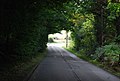
 A rudimentary bridge, Gilly Wood - geograph.org.uk - 2197725.jpg 640 × 430; 206 KB
-
 A268 - geograph.org.uk - 3765020.jpg 640 × 430; 89 KB
-
 A268 - geograph.org.uk - 3765035.jpg 640 × 430; 74 KB
-
 A268 - geograph.org.uk - 3765042.jpg 640 × 430; 72 KB
-
 A268 and B2088 junction, Beckley - geograph.org.uk - 2199059.jpg 640 × 430; 162 KB
-
 A268 enters Beckley - geograph.org.uk - 2988269.jpg 3,141 × 2,209; 1.66 MB
-
 A268 towards Peasmarsh - geograph.org.uk - 5784323.jpg 1,024 × 684; 322 KB
-
 A268 Whitebread Lane - geograph.org.uk - 5784543.jpg 1,024 × 684; 349 KB
-
 A268 Whitebread Lane - geograph.org.uk - 5784556.jpg 1,024 × 684; 230 KB
-
 A268, Four Oaks - geograph.org.uk - 3765010.jpg 640 × 490; 112 KB
-
 Aggregate pile by a modern Barn - geograph.org.uk - 2207141.jpg 640 × 430; 140 KB
-
 Alder Shaw - geograph.org.uk - 6220067.jpg 640 × 480; 149 KB
-
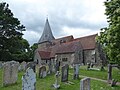
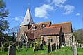 All Saints' church, Beckley - geograph.org.uk - 3928928.jpg 3,696 × 2,448; 2.17 MB
-
 All Saints, Beckley - geograph.org.uk - 4294451.jpg 1,600 × 1,179; 603 KB
-
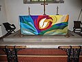 All Saints, Beckley, altar - geograph.org.uk - 6212610.jpg 640 × 480; 66 KB
-
 All Saints, Beckley, churchyard (a) - geograph.org.uk - 6212543.jpg 640 × 480; 82 KB
-
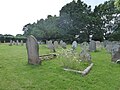 All Saints, Beckley, churchyard (b) - geograph.org.uk - 6212544.jpg 640 × 480; 88 KB
-
 All Saints, Beckley, churchyard (c) - geograph.org.uk - 6212545.jpg 480 × 640; 57 KB
-
 All Saints, Beckley, churchyard (d) - geograph.org.uk - 6212549.jpg 640 × 480; 124 KB
-
 All Saints, Beckley, early July 2019 - geograph.org.uk - 6206215.jpg 640 × 480; 83 KB
-
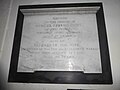
 All Saints, Beckley, ledger slab (A) - geograph.org.uk - 6212602.jpg 640 × 401; 76 KB
-
 All Saints, Beckley, ledger slab (B) - geograph.org.uk - 6212604.jpg 549 × 640; 97 KB
-
 All Saints, Beckley, ledger slab (C) - geograph.org.uk - 6212605.jpg 566 × 640; 117 KB
-
 All Saints, Beckley, ledger slab (D) - geograph.org.uk - 6212607.jpg 640 × 556; 113 KB
-
 All Saints, Beckley, lych gate - geograph.org.uk - 6212542.jpg 480 × 640; 86 KB
-
 All Saints, Beckley, memorial (a) - geograph.org.uk - 6212558.jpg 640 × 480; 39 KB
-
 All Saints, Beckley, memorial (b) - geograph.org.uk - 6212559.jpg 480 × 640; 45 KB
-
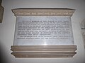 All Saints, Beckley, memorial (c) - geograph.org.uk - 6212560.jpg 640 × 480; 47 KB
-
 All Saints, Beckley, memorial (d) - geograph.org.uk - 6212582.jpg 640 × 480; 42 KB
-
 All Saints, Beckley, memorial (e) - geograph.org.uk - 6212588.jpg 640 × 480; 38 KB
-
 All Saints, Beckley, memorial (f) - geograph.org.uk - 6212592.jpg 640 × 622; 55 KB
-
 All Saints, Beckley, memorial (g) - geograph.org.uk - 6212593.jpg 640 × 479; 39 KB
-
 All Saints, Beckley, memorial (h) - geograph.org.uk - 6212594.jpg 640 × 480; 45 KB
-
 All Saints, Beckley, memorial (i) - geograph.org.uk - 6212595.jpg 640 × 368; 35 KB
-
 All Saints, Beckley, memorial (j) - geograph.org.uk - 6212596.jpg 640 × 404; 46 KB
-
 All Saints, Beckley, organ - geograph.org.uk - 6212611.jpg 480 × 640; 80 KB
-

-
-

-

-
 An entrance to Beckley Wood - geograph.org.uk - 6085006.jpg 1,024 × 768; 529 KB
-
 Ant Hills - geograph.org.uk - 6220049.jpg 640 × 480; 74 KB
-
 Autumn colours, Roger's Wood - geograph.org.uk - 6019304.jpg 1,024 × 681; 150 KB
-
 B2088 - geograph.org.uk - 5196549.jpg 640 × 426; 84 KB
-
 B2088 - geograph.org.uk - 5381423.jpg 640 × 426; 80 KB
-
 B2088 - geograph.org.uk - 6019305.jpg 1,024 × 681; 256 KB
-
 B2088 in Beckley - geograph.org.uk - 2988287.jpg 3,648 × 2,486; 1.4 MB
-
 B2088 passes the Rose and Crown - geograph.org.uk - 2988310.jpg 3,648 × 2,736; 1.83 MB
-
 B2088, Beckley - geograph.org.uk - 2199024.jpg 640 × 430; 175 KB
-
 B2088, Beckley - geograph.org.uk - 2199035.jpg 640 × 430; 159 KB
-
 B2088, Beckley - geograph.org.uk - 2199048.jpg 640 × 430; 159 KB
-
 B2088, Beckley - geograph.org.uk - 2199056.jpg 640 × 430; 130 KB
-
 B2088, Beckley - geograph.org.uk - 3765016.jpg 640 × 430; 60 KB
-
 B2088-B2165 junction, Beckley - geograph.org.uk - 5786250.jpg 1,024 × 684; 299 KB
-
 B2165 at Clayhill, East Sussex TN31 - geograph.org.uk - 61169.jpg 640 × 481; 97 KB
-
 B2165 towards Beckley - geograph.org.uk - 5784264.jpg 1,024 × 684; 276 KB
-
 Barber's Wood - geograph.org.uk - 4267345.jpg 640 × 480; 167 KB
-
 Barn Field - geograph.org.uk - 6220080.jpg 640 × 480; 70 KB
-
 Barns near Kitchenour - geograph.org.uk - 6217152.jpg 460 × 640; 73 KB
-
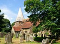
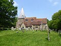 Beckley church - geograph.org.uk - 5784286.jpg 1,024 × 768; 320 KB
-
 Beckley Parsonage by Samuel Hieronymus Grimm 1784.jpg 928 × 712; 219 KB
-
 Beckley playing field - geograph.org.uk - 893761.jpg 640 × 480; 128 KB
-
 Beckley War Memorial - geograph.org.uk - 2988301.jpg 3,510 × 2,670; 2.15 MB
-
 Bend, A268 - geograph.org.uk - 3765022.jpg 640 × 430; 56 KB
-
 Birch Wood Beckley Furnace East Sussex - geograph.org.uk - 155470.jpg 640 × 480; 153 KB
-
 Bird in Hand, Beckley Furnace (geograph 6777786).jpg 1,024 × 684; 245 KB
-
 Bixley Lane - geograph.org.uk - 5381421.jpg 640 × 426; 92 KB
-
 Bixley Lane - geograph.org.uk - 6019306.jpg 1,024 × 576; 207 KB
-
 Bixley Wood from Kings Bank Lane - geograph.org.uk - 938402.jpg 640 × 480; 129 KB
-
 Brickhurst Field - geograph.org.uk - 6220088.jpg 640 × 480; 68 KB
-
 Bridleway beside the River Rother - geograph.org.uk - 1876974.jpg 3,072 × 2,304; 2.2 MB
-
 Broad-bodied chaser, Swallowtail Farm - geograph.org.uk - 5246872.jpg 708 × 532; 134 KB
-
 Brook Hop Garden - geograph.org.uk - 6239153.jpg 640 × 480; 58 KB
-
 Browns wood - geograph.org.uk - 896036.jpg 640 × 480; 189 KB
-
 Buddens Green off B2088, Beckley - geograph.org.uk - 2199043.jpg 640 × 430; 147 KB
-
 Burnt House Cottages, Hobbs Lane - geograph.org.uk - 5265370.jpg 2,753 × 2,065; 2.36 MB
-
 Burnt Wood - geograph.org.uk - 2207170.jpg 640 × 430; 193 KB
-
 Carmen Bridge - geograph.org.uk - 1774412.jpg 1,024 × 679; 287 KB
-
 Church Lane - geograph.org.uk - 2197749.jpg 640 × 430; 173 KB
-
 Closed Public house, Beckley - geograph.org.uk - 2199037.jpg 640 × 430; 114 KB
-
 Combs Field - geograph.org.uk - 6217134.jpg 640 × 480; 104 KB
-

-
 Converted Stable block, Rectory Lane - geograph.org.uk - 2197760.jpg 640 × 430; 176 KB
-
 Coombs Close, Four Oaks - geograph.org.uk - 6220092.jpg 640 × 457; 59 KB
-
 Coombs Cottages, Four Oaks - geograph.org.uk - 6220096.jpg 640 × 480; 68 KB
-
 Countryside near Decoypond Wood - geograph.org.uk - 3943060.jpg 640 × 480; 148 KB
-
 Cows ^ drainage channel near Maytham Wharf Farm - geograph.org.uk - 5373742.jpg 4,000 × 3,000; 2.65 MB
-
 Crossroads King's Bank Lane - geograph.org.uk - 938404.jpg 640 × 480; 127 KB
-
 Crossroads of Furnace, Horseshoe and Kings Bank lanes - geograph.org.uk - 1774549.jpg 1,600 × 1,061; 477 KB
-
 Decoypond Brook - geograph.org.uk - 6220047.jpg 640 × 480; 89 KB
-
 Decoypond Ditch - geograph.org.uk - 2764562.jpg 1,496 × 2,256; 851 KB
-
 Dencher Field - geograph.org.uk - 6220069.jpg 640 × 480; 92 KB
-
 Direction Sign - Signpost by the B2088, Beckley - geograph.org.uk - 6097981.jpg 805 × 1,553; 250 KB
-
 Donkey Lodge, Hobbs Lane, Four Oaks - geograph.org.uk - 6220090.jpg 583 × 640; 112 KB
-
 Drain near Knelle Pumping Station - geograph.org.uk - 2863569.jpg 2,256 × 1,496; 906 KB
-
 Dredging The Rother - geograph.org.uk - 2588389.jpg 3,968 × 2,232; 1.59 MB
-
 Dyke on Swallowtail Farm - geograph.org.uk - 5247524.jpg 2,816 × 2,112; 2.83 MB
-
 Early morning dew - geograph.org.uk - 1892266.jpg 2,048 × 1,536; 667 KB
-
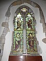
 East window, All Saints' church, Beckley - geograph.org.uk - 3928968.jpg 2,480 × 3,936; 7.51 MB
-
 Ebrofrost UK, Hobbs Lane, Four Oaks - geograph.org.uk - 6220086.jpg 480 × 640; 71 KB
-
 Edge of Decoypond Wood - geograph.org.uk - 1892247.jpg 640 × 480; 119 KB
-
 Electricity Pylon in Beckley Woods - geograph.org.uk - 1774554.jpg 1,061 × 1,600; 395 KB
-
 Electricity Pylon, Flatroper's Wood - geograph.org.uk - 2358213.jpg 1,496 × 2,256; 848 KB
-
 Electricity Pylons, Flatroper's Wood. - geograph.org.uk - 335237.jpg 479 × 640; 128 KB
-
 Entering Beckley - geograph.org.uk - 4843080.jpg 640 × 426; 104 KB
-
 Entering Beckley on the A268 - geograph.org.uk - 3931432.jpg 2,304 × 1,728; 813 KB
-
 Entrance to Little Knelle Farm - geograph.org.uk - 1774667.jpg 1,024 × 679; 307 KB
-
 Escheatlands Farm - geograph.org.uk - 4746286.jpg 4,000 × 3,000; 3.57 MB
-
 Evening Field - geograph.org.uk - 6220052.jpg 640 × 480; 59 KB
-
 Faggots, Beckley Woods - geograph.org.uk - 6085320.jpg 1,024 × 768; 527 KB
-

-
 Farmland near Beckley - geograph.org.uk - 4267167.jpg 640 × 430; 42 KB
-
 Field near Hop Barn - geograph.org.uk - 6031701.jpg 1,024 × 681; 98 KB
-
-
 Fields at Little Harmers Farm - geograph.org.uk - 2805775.jpg 640 × 319; 65 KB
-
 Fields at Little Harmers Farm - geograph.org.uk - 2806647.jpg 640 × 480; 65 KB
-
 Fields at Little Harmers Farm - geograph.org.uk - 2806648.jpg 640 × 149; 29 KB
-
 Fields at Little Harmers Farm - geograph.org.uk - 2806650.jpg 640 × 480; 95 KB
-
 Fields at Little Harmers Farm - geograph.org.uk - 2806651.jpg 640 × 480; 87 KB
-
 Fields by Hundred House Lane - geograph.org.uk - 2693341.jpg 640 × 480; 73 KB
-
 Fields by the River Rother - geograph.org.uk - 2863573.jpg 2,256 × 1,496; 933 KB
-
 Fields near Decoypond Ditch - geograph.org.uk - 2764555.jpg 640 × 424; 70 KB
-
 Fields near Rogers Wood - geograph.org.uk - 1774676.jpg 1,024 × 679; 141 KB
-
 Fields near Weavers Farm - geograph.org.uk - 2806678.jpg 640 × 270; 64 KB
-
 Flatroper's Wood - geograph.org.uk - 335222.jpg 479 × 640; 231 KB
-
 Flatroper's Wood - geograph.org.uk - 335239.jpg 479 × 640; 215 KB
-

-
 Footpath Bixley Woods - geograph.org.uk - 895078.jpg 480 × 640; 146 KB
-
 Footpath Bixley Woods - geograph.org.uk - 895081.jpg 480 × 640; 149 KB
-
 Footpath Bixley Woods - geograph.org.uk - 896039.jpg 480 × 640; 159 KB
-
 Footpath to Kitchenour Lane - geograph.org.uk - 2207147.jpg 640 × 430; 139 KB
-
 Footway Field-Fatten Lodge Field - geograph.org.uk - 6239151.jpg 640 × 480; 47 KB
-
 For sale on Furnace Lane - geograph.org.uk - 3880741.jpg 640 × 480; 191 KB
-
 Furnace Lane - geograph.org.uk - 3880732.jpg 640 × 480; 181 KB
-
 Furnace Lane, near Glass Eye farm - geograph.org.uk - 1774544.jpg 1,024 × 679; 231 KB
-
 Garage Doors shop - geograph.org.uk - 2199052.jpg 640 × 430; 125 KB
-
 Gate House, Horseshoe Lane - geograph.org.uk - 4746289.jpg 4,000 × 3,000; 4 MB
-
 Gate on the footpath east of Beckley - geograph.org.uk - 2207128.jpg 640 × 430; 172 KB
-
 Good Field-Loam Field - geograph.org.uk - 6239157.jpg 640 × 480; 55 KB
-
 Great Brook-Lower Dencher Field - geograph.org.uk - 6239164.jpg 640 × 481; 71 KB
-
 Greeland Field - geograph.org.uk - 6220051.jpg 640 × 480; 91 KB
-
 Guardians of Hobbs Lane - geograph.org.uk - 1892316.jpg 2,048 × 1,536; 668 KB
-
 Hay barn, Willowdale Farm - geograph.org.uk - 2197744.jpg 640 × 430; 135 KB
-
 Hayesland Farm House - geograph.org.uk - 2691486.jpg 640 × 282; 73 KB
-
 Hazard on a rural A road - geograph.org.uk - 4267144.jpg 640 × 430; 93 KB
-
 Headland Strip by Sugar beet - geograph.org.uk - 2198981.jpg 640 × 430; 163 KB
-
 Hexden Channel flowing towards the River Rother - geograph.org.uk - 1877138.jpg 3,072 × 2,304; 1.92 MB
-
 Hobb's Farm Oast, Hobbs Lane, Beckley - geograph.org.uk - 4941512.jpg 4,000 × 3,000; 3.4 MB
-
 Hobbs Cottage, Hobbs Lane - geograph.org.uk - 6220075.jpg 640 × 480; 93 KB
-
 Hobbs Farmhouse, Hobbs Lane - geograph.org.uk - 6220078.jpg 640 × 480; 72 KB
-
 Hobbs Lane, Beckley - geograph.org.uk - 2199062.jpg 640 × 430; 180 KB
-
 Hobbs Lane, Four Oaks - geograph.org.uk - 5784568.jpg 1,024 × 684; 261 KB
-

-
 Hobbs Lane, looking through gate at north end - geograph.org.uk - 2381402.jpg 1,024 × 681; 198 KB
-
 Hobbs Lane, the north end - geograph.org.uk - 2381269.jpg 1,024 × 681; 251 KB
-
 Hobbs Lane, view through gate at north end - geograph.org.uk - 2381397.jpg 1,024 × 681; 172 KB
-
 Hobbs' Farm, Swallowtail Hill - geograph.org.uk - 5242762.jpg 1,521 × 1,169; 629 KB
-
 Hollow Combs - geograph.org.uk - 6217148.jpg 640 × 480; 88 KB
-
 Hornbeams in Flatropers Wood - geograph.org.uk - 5242695.jpg 871 × 1,014; 577 KB
-
 House Field - geograph.org.uk - 6220065.jpg 640 × 480; 68 KB
-
 House Field - geograph.org.uk - 6220076.jpg 640 × 480; 75 KB
-
 House Field-Nine Acres - geograph.org.uk - 6217160.jpg 640 × 480; 83 KB
-
 House on Hobbs Lane, near Knelle Wood - geograph.org.uk - 1775204.jpg 1,024 × 679; 252 KB
-
 Houses on the edge of Beckley - geograph.org.uk - 2199017.jpg 640 × 430; 125 KB
-
 Hundredhouse Bridge - geograph.org.uk - 6239167.jpg 486 × 640; 84 KB
-
 Hundredhouse Lane - geograph.org.uk - 1509114.jpg 640 × 424; 79 KB
-
 I just missed it^ - geograph.org.uk - 6210675.jpg 640 × 480; 106 KB
-
 Inside All Saints, Beckley (A) - geograph.org.uk - 6212597.jpg 640 × 480; 80 KB
-
 Inside All Saints, Beckley (B) - geograph.org.uk - 6212598.jpg 480 × 640; 66 KB
-
 Inside All Saints, Beckley (C) - geograph.org.uk - 6212599.jpg 640 × 480; 78 KB
-
 Inside All Saints, Beckley (D) - geograph.org.uk - 6212600.jpg 480 × 640; 64 KB
-

-
 Junction of Kitchenour Lane and A268 - geograph.org.uk - 967408.jpg 640 × 480; 119 KB
-

-
 Kent and East Sussex Railway - geograph.org.uk - 5373722.jpg 4,000 × 3,000; 4.08 MB
-
 Kent and East Sussex Railway bridge over the River Rother - geograph.org.uk - 1877011.jpg 3,072 × 2,304; 1.89 MB
-
 King's Bank Lane - geograph.org.uk - 3880750.jpg 640 × 480; 166 KB
-
 Kings Bank Lane - geograph.org.uk - 938398.jpg 480 × 640; 124 KB
-
 Kitchenour Lane - geograph.org.uk - 2207160.jpg 640 × 430; 152 KB
-
 Kitchenour Lane - geograph.org.uk - 2207162.jpg 640 × 430; 162 KB
-
 Kitchenour Lane - geograph.org.uk - 2207166.jpg 640 × 430; 189 KB
-
 Kitchenour Lane - geograph.org.uk - 2207167.jpg 640 × 430; 149 KB
-
 Kitchenour Lane - geograph.org.uk - 4267131.jpg 640 × 288; 44 KB
-
 Kitchenour Lane - geograph.org.uk - 5784577.jpg 1,024 × 684; 283 KB
-
 Kitchenour Lane - geograph.org.uk - 6031693.jpg 1,024 × 681; 208 KB
-
 Kitchenour Lane off the A268 - geograph.org.uk - 3764957.jpg 640 × 430; 84 KB
-
 Kitchenour, Kitchenour Lane - geograph.org.uk - 2207156.jpg 640 × 430; 142 KB
-
 Kitchenour, Kitchenour Lane - geograph.org.uk - 6217166.jpg 528 × 640; 113 KB
-
 Knelle Gate - geograph.org.uk - 3765040.jpg 640 × 407; 78 KB
-
 Knelle Gate, A268 - geograph.org.uk - 5196554.jpg 640 × 426; 81 KB
-
 Knelle Pumping Station - geograph.org.uk - 2583740.jpg 2,256 × 1,496; 805 KB
-
 Knelle Pumping Station on the River Rother - geograph.org.uk - 1877022.jpg 3,072 × 2,304; 1.68 MB
-
 Land near Glass Eye Farm, Furnace Lane - geograph.org.uk - 1774542.jpg 1,600 × 1,129; 406 KB
-
 Land opposite Hayes Farmhouse - geograph.org.uk - 1509132.jpg 640 × 424; 80 KB
-

-
 Leylandii hedge on western border of Dinglesden Wood - geograph.org.uk - 5504973.jpg 2,272 × 1,704; 1.43 MB
-
 Little Bellhurst Farm - geograph.org.uk - 2381249.jpg 1,024 × 681; 226 KB
-
 Lodge Field - geograph.org.uk - 6220050.jpg 640 × 480; 82 KB
-
 Log pile, Willowdale Farm - geograph.org.uk - 2197740.jpg 640 × 430; 208 KB


_-_geograph.org.uk_-_6212543.jpg)
_-_geograph.org.uk_-_6212544.jpg)
_-_geograph.org.uk_-_6212545.jpg)
_-_geograph.org.uk_-_6212549.jpg)

_-_geograph.org.uk_-_6212602.jpg)
_-_geograph.org.uk_-_6212604.jpg)
_-_geograph.org.uk_-_6212605.jpg)
_-_geograph.org.uk_-_6212607.jpg)

_-_geograph.org.uk_-_6212558.jpg)
_-_geograph.org.uk_-_6212559.jpg)
_-_geograph.org.uk_-_6212560.jpg)
_-_geograph.org.uk_-_6212582.jpg)
_-_geograph.org.uk_-_6212588.jpg)
_-_geograph.org.uk_-_6212592.jpg)
_-_geograph.org.uk_-_6212593.jpg)
_-_geograph.org.uk_-_6212594.jpg)
_-_geograph.org.uk_-_6212595.jpg)
_-_geograph.org.uk_-_6212596.jpg)

_-_geograph.org.uk_-_6212613.jpg)
_-_geograph.org.uk_-_6212614.jpg)
_-_geograph.org.uk_-_6212616.jpg)
_-_geograph.org.uk_-_6212618.jpg)


.jpg)


_-_geograph.org.uk_-_6212597.jpg)
_-_geograph.org.uk_-_6212598.jpg)
_-_geograph.org.uk_-_6212599.jpg)
_-_geograph.org.uk_-_6212600.jpg)


