Category:Bathymetric maps of the Great Lakes
Jump to navigation
Jump to search
Subcategories
This category has the following 2 subcategories, out of 2 total.
S
Media in category "Bathymetric maps of the Great Lakes"
The following 63 files are in this category, out of 63 total.
-
 Another NOAA map of Lake Ontario.jpg 5,308 × 3,638; 1.85 MB
-
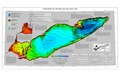 Bathymetry of Lake Erie and Lake St. Clair Poster.pdf 4,200 × 2,700; 1.48 MB
-
 Bay of Quinte, NOAA.jpg 3,092 × 1,680; 906 KB
-

-
 Central Erie Basin.jpg 2,374 × 1,923; 2.32 MB
-
 Central portion of Lake Erie (north).jpg 1,401 × 1,800; 1.24 MB
-
 Central portion of Lake Erie (south).jpg 1,420 × 1,800; 1.34 MB
-
 Coast of Lake Erie, west of Port Maitland and the mouth of the Grand River.jpg 1,572 × 645; 986 KB
-

-
 Eastern Erie Basin, Long Point.jpg 1,824 × 1,273; 2.03 MB
-
 Eastern portion of Lake Erie, where the Grand River and Welland Canal empty into it..jpg 1,401 × 1,800; 1.36 MB
-
 Eastern tip of Lake Erie, near Buffalo, NY, and the source of the Niagara River.jpg 1,401 × 1,800; 1.72 MB
-
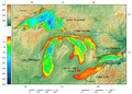
 Great Lakes 2 hu.png 1,500 × 759; 237 KB
-
 Great Lakes 2.PNG 1,500 × 759; 260 KB
-
 Great Lakes bathymetry map 2.png 1,024 × 731; 943 KB
-
 Great Lakes bathymetry map.png 1,024 × 731; 1.34 MB
-
 Islands in Lake Erie.jpg 1,428 × 1,118; 1.17 MB
-
 Jmse-04-00046-g001-1024.png 515 × 1,024; 332 KB
-
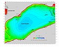
 Lake Erie and Lake Saint Clair bathymetry map 2.png 1,024 × 684; 512 KB
-
 Lake Erie and Lake Saint Clair bathymetry map.png 1,024 × 684; 766 KB
-
 Lake Erie's Long Point.jpg 1,401 × 1,800; 1.29 MB
-
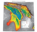
 Lake Huron bathymetry map 2.png 936 × 1,024; 878 KB
-
 Lake Huron bathymetry map.png 936 × 1,024; 1.35 MB
-
 Lake Huron bathymetry.pdf 6,300 × 5,400; 16.87 MB
-
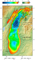
 Relief Map of Lake Michigan.tiff 443 × 664; 319 KB
-
 Lake Michigan bathymetry map 2.png 597 × 1,024; 600 KB
-
 Lake Michigan bathymetry map.png 597 × 1,024; 948 KB
-
 Lake Ontario bathymetry map 2.png 1,024 × 656; 470 KB
-
 Lake Ontario bathymetry map.png 1,024 × 656; 750 KB
-
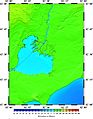 Lake St Clair, and the northern part of Point Pelee, NOAA.jpg 1,401 × 1,800; 1.32 MB
-
 Lake Superior bathymetry map 2.png 1,024 × 636; 699 KB
-
 Lake Superior bathymetry map, deepest point 2.png 700 × 855; 383 KB
-
 Lake Superior bathymetry map, deepest point, trenches 2.png 1,024 × 1,348; 940 KB
-
 Lake Superior bathymetry map, deepest point, trenches.png 1,024 × 1,348; 1.36 MB
-
 Lake Superior bathymetry map, deepest point.png 895 × 1,539; 587 KB
-
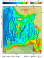
 Lake Superior bathymetry map.png 1,024 × 636; 1,014 KB
-
 Long Point spit, Presqu'ile spit, and the Lake Erie ridges between them.jpg 1,537 × 2,161; 607 KB
-
 Michigan, NW of Lake Erie, NOAA.jpg 1,401 × 1,800; 1.58 MB
-
 Most islands of Lake Erie, NOAA.jpg 1,420 × 1,800; 1.28 MB
-

-
 NOAA bathymetric map of Lake Ontario's Rochester Basin.jpg 2,820 × 2,012; 4.61 MB
-
 NOAA Bathymetric map of the Niagara Basin.jpg 2,504 × 1,908; 2.59 MB
-
 NOAA bathymetric map of the Niagara Fan.jpg 2,211 × 1,527; 1.28 MB
-
 NOAA bathymetric map of the West and East Kingston Basins.jpg 3,012 × 2,032; 3.78 MB
-
 NOAA Lake Michigan bathymetry -a.gif 1,903 × 1,916; 1.34 MB
-
 NOAA Lake Michigan bathymetry -b.gif 1,724 × 2,145; 1.15 MB
-
 NOAA Lake Michigan bathymetry -c.gif 1,903 × 2,186; 1.4 MB
-
 NOAA Lake Michigan bathymetry -d.gif 2,062 × 2,200; 1.26 MB
-
 NOAA Lake Michigan bathymetry -e.gif 1,382 × 852; 357 KB
-
 NOAA Lake Michigan bathymetry -f.gif 1,555 × 1,693; 1.08 MB
-
 NOAA Lake Michigan bathymetry -g.gif 1,270 × 1,788; 529 KB
-
 NOAA Lake Michigan bathymetry.gif 459 × 685; 83 KB
-
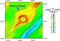 NOAA map of Charity Shoal in Lake Ontario.jpg 2,340 × 1,596; 1.51 MB
-

-
 NOAA map of Duck Galloo Ridge.jpg 2,736 × 2,228; 3.47 MB
-
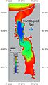 NOAA map of Irondequoit Bay.jpg 1,315 × 2,280; 654 KB
-
 NOAA map of Scotch Bonnet Ridge.jpg 3,096 × 2,108; 5.17 MB
-
 North and east shores of Lake Erie, from Buffalo to 79.20.jpg 1,766 × 747; 1.15 MB
-

-
 Pelee and nearby islands in Lake Erie.jpg 894 × 1,195; 643 KB
-
 Sandusky basin.jpg 1,426 × 1,832; 1.67 MB
-
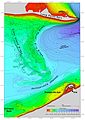
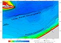 The tip of Ontario's Long Point, the Long Point Escarpment and the Dunkirk Escarpment.jpg 1,686 × 1,194; 1.82 MB
-
 West end of Lake Erie.jpg 1,420 × 1,800; 1.77 MB


.jpg)
.jpg)


_showing_Timber,_Swetman,_Main_Duck_and_Yorkshire_islands,_and_some_subsurface_shoals.jpg)


