Category:Bartholomeuskerk, Beerta
Jump to navigation
Jump to search
| Object location | | View all coordinates using: OpenStreetMap |
|---|
church building in Beerta, Netherlands  | |||||
| Upload media | |||||
| Instance of | |||||
|---|---|---|---|---|---|
| Location | Beerta, Oldambt, Groningen, Netherlands | ||||
| Street address |
| ||||
| Located on street |
| ||||
| Has part(s) | |||||
| Heritage designation |
| ||||
| Inception |
| ||||
| Religion or worldview | |||||
 | |||||
Nederlands: Bartholomeuskerk, Beerta - anno 1506 - toren anno 1806
Kerk
|
This is a category about rijksmonument number 8868
|
Toren
|
This is a category about rijksmonument number 8867
|
| Address |
|
Media in category "Bartholomeuskerk, Beerta"
The following 51 files are in this category, out of 51 total.
-
 Bartholomeuskerk Beerta 1.jpg 3,648 × 2,736; 2.19 MB
-
 Bartholomeuskerk Beerta 2.jpg 3,648 × 2,736; 2.31 MB
-
 Bartholomeuskerk Beerta 3.jpg 2,736 × 3,648; 2.17 MB
-
 Bartholomeuskerk Beerta 4.jpg 3,648 × 2,736; 2.47 MB
-
 Bartholomeuskerk Beerta 5.jpg 2,736 × 3,648; 2.2 MB
-
 Bartholomeuskerk Beerta 6.jpg 3,648 × 2,736; 2.37 MB
-
 Bartholomeuskerk Beerta 7.jpg 3,648 × 2,736; 2.01 MB
-
 Bartholomeuskerk Beerta 8.jpg 2,736 × 3,648; 1.99 MB
-
 Bartholomeuskerk Beerta 9.jpg 2,736 × 3,648; 2.27 MB
-
 Beerta Kerk.JPG 2,816 × 2,112; 2.79 MB
-
 Beerta Toren.JPG 2,112 × 2,816; 1.81 MB
-
 Beerta, toren 2007-05-20 12.00.JPG 1,704 × 2,272; 1.23 MB
-
 Ext. v.h.Z.W. - Beerta - 20029626 - RCE.jpg 1,200 × 866; 278 KB
-
 Ext. v.h.Z.W. en v.h.N. - Beerta - 20029623 - RCE.jpg 1,200 × 853; 279 KB
-
 Ext. v.h.Z.W. en v.h.N. - Beerta - 20029624 - RCE.jpg 1,200 × 870; 326 KB
-
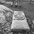
 Exterieur DETAIL GRAFZERK - Beerta - 20295465 - RCE.jpg 1,186 × 1,200; 479 KB
-
 Exterieur GRAFZERK - Beerta - 20295463 - RCE.jpg 1,190 × 1,200; 490 KB
-
 Exterieur GRAFZERK - Beerta - 20295464 - RCE.jpg 1,197 × 1,200; 526 KB
-
 Exterieur GRAFZERK - Beerta - 20295476 - RCE.jpg 1,200 × 1,200; 496 KB
-
 Exterieur GRAFZERKEN - Beerta - 20295472 - RCE.jpg 1,185 × 1,200; 457 KB
-
 Exterieur GRAFZERKEN - Beerta - 20295473 - RCE.jpg 1,190 × 1,200; 403 KB
-
 Exterieur GRAFZERKEN - Beerta - 20295474 - RCE.jpg 1,197 × 1,200; 477 KB
-
 Exterieur GRAFZERKEN - Beerta - 20295475 - RCE.jpg 1,200 × 1,197; 502 KB
-
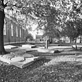
 Exterieur OVERZICHT - Beerta - 20295461 - RCE.jpg 1,192 × 1,200; 489 KB
-
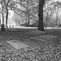
 Exterieur OVERZICHT BEGRAAFPLAATS - Beerta - 20295462 - RCE.jpg 1,200 × 1,192; 494 KB
-
 Exterieur OVERZICHT BEGRAAFPLAATS - Beerta - 20295466 - RCE.jpg 1,195 × 1,200; 511 KB
-
 Exterieur OVERZICHT BEGRAAFPLAATS - Beerta - 20295467 - RCE.jpg 1,190 × 1,200; 499 KB
-
 Exterieur OVERZICHT GRAFZERKEN - Beerta - 20295468 - RCE.jpg 1,197 × 1,200; 559 KB
-
 Exterieur OVERZICHT GRAFZERKEN - Beerta - 20295469 - RCE.jpg 1,183 × 1,200; 441 KB
-
 Exterieur OVERZICHT GRAFZERKEN - Beerta - 20295470 - RCE.jpg 1,190 × 1,200; 495 KB
-
 Exterieur OVERZICHT GRAFZERKEN - Beerta - 20295471 - RCE.jpg 1,200 × 1,197; 520 KB
-
 Hervormde kerk, vrijstaande toren Beerta 1.jpg 2,736 × 3,648; 2.29 MB
-
 Hervormde kerk, vrijstaande toren Beerta 2.jpg 2,736 × 3,648; 2.05 MB
-
 Ijzeren standaards - Beerta - 20029634 - RCE.jpg 860 × 1,200; 277 KB
-
 Interieur - Beerta - 20322693 - RCE.jpg 1,200 × 784; 142 KB
-
 Interieur naar het oosten - Beerta - 20029629 - RCE.jpg 957 × 1,200; 214 KB
-
 Interieur naar het westen - Beerta - 20029627 - RCE.jpg 1,200 × 852; 166 KB
-
 Interieur naar het westen - Beerta - 20029628 - RCE.jpg 967 × 1,200; 217 KB
-
 Interieur, aanzicht orgel, orgelnummer 139 - Beerta - 20370263 - RCE.jpg 879 × 1,200; 163 KB
-
 Kerkzaal en toren - Beerta - 20322692 - RCE.jpg 1,200 × 785; 267 KB
-
 N.O. zijde toren - Beerta - 20029637 - RCE.jpg 953 × 1,200; 191 KB
-
 N.W. zijde toren - Beerta - 20029636 - RCE.jpg 968 × 1,200; 174 KB
-
 Opschrift op steen - Beerta - 20029635 - RCE.jpg 1,200 × 963; 341 KB
-
 Orgel - Beerta - 20029630 - RCE.jpg 957 × 1,200; 224 KB
-
 Overzicht vrijstaande kerktoren - Beerta - 20364964 - RCE.jpg 944 × 1,200; 214 KB
-

-
 Poortje W. gevel - Beerta - 20029625 - RCE.jpg 861 × 1,200; 333 KB
-
 Preekstoel - Beerta - 20029631 - RCE.jpg 1,200 × 860; 124 KB
-
 Tinnen kan en schotel - Beerta - 20029632 - RCE.jpg 863 × 1,200; 209 KB
-
 Toren, Z.W. zijde - Beerta - 20029638 - RCE.jpg 961 × 1,200; 204 KB
-
 Zilveren beker - Beerta - 20029633 - RCE.jpg 827 × 1,200; 175 KB


