Category:Avant-port de Honfleur
Jump to navigation
Jump to search
|
This building is inscrit au titre des monuments historiques de la France. It is indexed in the base Mérimée, a database of architectural heritage maintained by the French Ministry of Culture, under the reference PA00135499
|
| Object location | | View all coordinates using: OpenStreetMap |
|---|
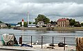
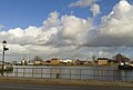
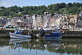
Lighthouse, signal mast, beacon hut on the docks of the basins built in the 19th century.  | |||||
| Upload media | |||||
| Instance of | |||||
|---|---|---|---|---|---|
| Location | Honfleur, canton of Honfleur | ||||
| Heritage designation |
| ||||
 | |||||
Media in category "Avant-port de Honfleur"
The following 40 files are in this category, out of 40 total.
-
 7 of 10 - Honfleur, Calvados Normandy - FRANCE.jpg 2,773 × 1,849; 824 KB
-
 Avant-Port d'Honfleur Vue 1.jpg 2,210 × 3,933; 3.96 MB
-
 Avant-Port d'Honfleur Vue 2.jpg 2,962 × 3,950; 5.04 MB
-
 Avant-Port d'Honfleur Vue 3.jpg 2,981 × 3,977; 5.53 MB
-
 Avant-Port d'Honfleur Vue 4.jpg 2,944 × 3,926; 5.97 MB
-
 Avant-port de Honfleur en 1966.jpg 4,320 × 2,880; 2.82 MB
-
 Avant-port honfleur 06.jpg 5,472 × 3,648; 3.59 MB
-
 France Normandie 14 Honfleur 01.jpg 3,008 × 2,000; 2.43 MB
-
 France Normandie 14 Honfleur 05.jpg 3,008 × 2,000; 2.06 MB
-
 France Normandie 14 Honfleur 06.jpg 3,008 × 2,000; 2.94 MB
-
 France Normandie 14 Honfleur 07.jpg 3,008 × 2,000; 2.93 MB
-
 France Normandie 14 Honfleur 08.jpg 3,008 × 2,000; 2.35 MB
-
 France Normandie 14 Honfleur 09.jpg 3,008 × 2,000; 2.53 MB
-
 France Normandie 14 Honfleur 11.jpg 3,008 × 2,000; 2.42 MB
-
 France-000540 - Honfleur Lighthouse (14936984785).jpg 6,000 × 4,000; 27.81 MB
-
 France-000541 - Honfleur Lighthouse (14936993825).jpg 4,000 × 6,000; 13.09 MB
-
 France-000578 - Honfleur Lighthouse (14934188781).jpg 4,000 × 6,000; 22.88 MB
-
 France-000580 - Honfleur Lighthouse (14750616929).jpg 4,000 × 6,000; 14.05 MB
-
 Honfleur - Avant-port 01.jpg 3,648 × 2,736; 2.44 MB
-
 Honfleur - Avant-port 02.jpg 3,648 × 2,736; 2.78 MB
-
 Honfleur - Avant-port 03.jpg 3,648 × 2,736; 2.93 MB
-
 Honfleur 0635.jpg 1,594 × 1,000; 1.4 MB
-
 Honfleur Avant-Port PA00135499 01 JPM.JPG 2,208 × 1,240; 1.11 MB
-
 Honfleur Avant-Port PA00135499 02 JPM.JPG 2,208 × 1,240; 1.54 MB
-
 Honfleur DP2Q0137.jpg 7,680 × 5,120; 17.9 MB
-
 Honfleur DP2Q0149.jpg 7,680 × 5,120; 14.52 MB
-
 Honfleur DP2Q0153.jpg 7,680 × 5,120; 18.01 MB
-
 Honfleur DP2Q0155.jpg 7,680 × 5,120; 17.25 MB
-
 Honfleur Lighthouse 8-6-2008 - panoramio.jpg 850 × 638; 109 KB
-
 Honfleur, Avant-Port, Panorama.jpg 13,068 × 3,321; 20.57 MB
-
 Honfleur-Sémaphore de l'avant-port-20120914.jpg 4,272 × 2,848; 2.35 MB
-
 Honfleur6.jpg 2,524 × 1,696; 2.15 MB
-
 PAIC37HonfleurAvPort1.JPG 5,184 × 3,456; 7.97 MB
-
 PAIC37HonfleurAvPort2.JPG 5,184 × 3,456; 5.89 MB
-
 Pano avant-port 01.jpg 1,803 × 539; 696 KB
-
 Pano avant-port 02.jpg 2,410 × 539; 967 KB
-
 Planchette honfleur 01.jpg 7,680 × 5,120; 17.1 MB
-
 Planchette honfleur 02.jpg 7,680 × 5,120; 18.73 MB
-
 Port de Honfleur 05.jpg 7,680 × 5,120; 17.36 MB
-
 Port de Honfleur 06.jpg 7,680 × 5,120; 14.2 MB


.jpg)
.jpg)
.jpg)
.jpg)


