Category:Australia photographs taken on 2014-05-15
Jump to navigation
Jump to search

Media in category "Australia photographs taken on 2014-05-15"
The following 69 files are in this category, out of 69 total.
-
 1 Coast Hospital Rd, Little Bay NSW 2036, Australia - panoramio.jpg 2,368 × 3,200; 1.1 MB
-
 11 Seaside Parade, South Coogee NSW 2034, Australia - panoramio.jpg 3,200 × 2,368; 1.81 MB
-
 42 Marine Parade, Maroubra NSW 2035, Australia - panoramio (1).jpg 3,200 × 2,368; 1.77 MB
-
 42 Marine Parade, Maroubra NSW 2035, Australia - panoramio (2).jpg 3,200 × 2,368; 1.49 MB
-
 42 Marine Parade, Maroubra NSW 2035, Australia - panoramio.jpg 3,200 × 2,368; 1.37 MB
-
 Aerial photograph of the Tasman Sea 01.jpg 3,200 × 2,368; 1.55 MB
-
 Aerial photograph of the Tasman Sea 02.jpg 3,200 × 2,368; 1.55 MB
-
 Aerial photograph of the Tasman Sea 03.jpg 3,200 × 2,368; 1.61 MB
-
 Beehive Market - panoramio.jpg 1,267 × 800; 391 KB
-
 Boronia Heights State School building, 2014.JPG 1,920 × 1,080; 460 KB
-
 Boronia Heights State School, 2014.JPG 1,920 × 1,080; 474 KB
-
 Browns Plains police station, 2014.JPG 1,920 × 1,080; 479 KB
-
 Coates Hire, Crestmead Industrial Estate, 2014.JPG 1,920 × 1,080; 490 KB
-
 Coburg North VIC 3058, Australia - panoramio.jpg 3,264 × 2,448; 2.71 MB
-
 Crestmead Community Centre, 2014.JPG 1,920 × 1,080; 481 KB
-
 Dairy Farmers milk factory, Crestmead Industrial Estate, 2014.JPG 1,920 × 1,080; 488 KB
-
 Danger sign, Greenbank Military Range, 2014.JPG 1,920 × 1,080; 484 KB
-
 East Melbourne VIC 3002, Australia - panoramio (6).jpg 3,200 × 2,368; 2.31 MB
-
 Emus in Weddin Mountains National Park.JPG 5,184 × 3,456; 5.67 MB
-
 Ettrema NSW 2540, Australia - panoramio.jpg 3,264 × 2,448; 1.04 MB
-
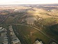
 Farm land outside Ninda township 2014-05-15.jpg 3,264 × 2,448; 2.5 MB
-
 Floodplain near the Gwydir River, Watercourse Road, Moree, 2014. Peter Neaum. - panoramio.jpg 9,897 × 3,580; 13.27 MB
-
 Football field, Greenbank, 2014.JPG 1,920 × 1,080; 486 KB
-
 Greenbank Military Camp, 2014.JPG 1,080 × 1,920; 405 KB
-
 High Street - panoramio (2).jpg 1,771 × 800; 661 KB
-
-
 Industrial units, Crestmead Industrial Estate, 2014.JPG 1,920 × 1,080; 478 KB
-
 Keilor East VIC 3033, Australia - panoramio (2).jpg 3,264 × 2,448; 1.71 MB
-
 Keilor East VIC 3033, Australia - panoramio (3).jpg 3,264 × 2,448; 2.57 MB
-
 Keilor Terminal Station AUS 2014.jpg 1,552 × 992; 367 KB
-
 Kosciuszko National Park NSW 2627, Australia - panoramio (342).jpg 3,264 × 2,448; 1.26 MB
-
 Kosciuszko National Park NSW 2627, Australia - panoramio (343).jpg 3,264 × 2,448; 1.37 MB
-
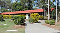
 Logan West community centre (from the car park), Hillcrest, 2014.JPG 1,920 × 1,080; 483 KB
-
 Logan West community centre (main venue), Hillcrest, 2014.JPG 1,920 × 1,080; 486 KB
-
 Logan West community centre, Hillcrest, 2014.JPG 1,920 × 1,080; 480 KB
-
 Main Street ^1 - panoramio.jpg 1,482 × 800; 544 KB
-
 Main Street ^2 - panoramio.jpg 2,931 × 800; 1.21 MB
-
 Main Street ^3 - panoramio.jpg 2,762 × 800; 840 KB
-
 Maroubra NSW 2035, Australia - panoramio.jpg 3,200 × 2,368; 1.81 MB
-
 Moollattoo NSW 2540, Australia - panoramio.jpg 3,264 × 2,448; 1.01 MB
-
 Motorcyclist in protective clothing back.JPG 2,448 × 3,264; 2.59 MB
-
 Motorcyclist in protective clothing front.JPG 2,448 × 3,264; 2.42 MB
-
 Murrindindi VIC 3717, Australia - panoramio.jpg 3,264 × 2,448; 2.49 MB
-
 Numbellie Karulboo Community Centre, 2014.JPG 1,920 × 1,080; 481 KB
-
 Original Greenbank State School building, 2014.JPG 1,920 × 1,080; 464 KB
-
 Pagewood NSW 2035, Australia - panoramio.jpg 3,200 × 2,368; 1.53 MB
-
 Pascoe Vale VIC 3044, Australia - panoramio.jpg 3,264 × 2,448; 2.77 MB
-
 Reservoir VIC 3073, Australia - panoramio (1).jpg 3,264 × 2,448; 2.97 MB
-
 Reservoir VIC 3073, Australia - panoramio (2).jpg 3,264 × 2,448; 2.82 MB
-
 Reservoir VIC 3073, Australia - panoramio (3).jpg 2,448 × 3,264; 2.79 MB
-
 Reservoir VIC 3073, Australia - panoramio (4).jpg 3,264 × 2,448; 2.71 MB
-
 Reservoir VIC 3073, Australia - panoramio.jpg 3,264 × 2,448; 2.74 MB
-
 Rest area outside Ninda 2014-05-15.jpg 3,264 × 2,448; 2.62 MB
-
 Rotunda and water garden, Logan West Community Centre, 2014.JPG 1,920 × 1,080; 471 KB
-
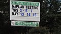 Sign announcing NAPLAN tests, Greenbank State School, 2014.JPG 1,920 × 1,080; 484 KB
-
 Sign for the 25th & 49th Battalion, Greenbank Military Range, 2014.JPG 1,920 × 1,080; 488 KB
-
 Sign, Greenbank Sport & Recreation Club, 2014.JPG 1,920 × 1,080; 482 KB
-
 St Francis College, Crestmead, 2014.JPG 1,920 × 1,080; 472 KB
-
 Tallowal NSW 2540, Australia - panoramio.jpg 3,264 × 2,448; 1.18 MB
-
 The Royal Botanical Garden of Sydney - Pond.JPG 4,608 × 3,456; 7.67 MB
-
 The Royal Botanical Garden of Sydney.JPG 4,608 × 3,456; 7.39 MB
-
 Wineglass Water Tower, Hillcrest, 2014.JPG 1,080 × 1,920; 446 KB
-
 Wollongong NSW, Australia - panoramio (23).jpg 3,200 × 2,368; 1.34 MB
-
 Wollongong NSW, Australia - panoramio (24).jpg 3,200 × 2,368; 1.4 MB
-
 Wollongong NSW, Australia - panoramio (25).jpg 2,368 × 3,200; 1.27 MB
-
 Yaouk NSW 2629, Australia - panoramio.jpg 3,264 × 2,448; 1.14 MB
-
 Yellow Rock NSW 2527, Australia - panoramio.jpg 2,448 × 3,264; 1.19 MB
-
 Yugumbir State School, 2014.JPG 1,920 × 1,080; 473 KB
-
 Yugumbir State School, Regents Park, 2014.JPG 1,920 × 1,080; 474 KB


.jpg)
.jpg)


.jpg)


.jpg)
_distribution_centre,_Crestmead_Industrial_Estate,_2014.JPG)

.jpg)
.jpg)

.jpg)
.jpg)
,_Hillcrest,_2014.JPG)
,_Hillcrest,_2014.JPG)


.jpg)
.jpg)
.jpg)
.jpg)


.jpg)
.jpg)
.jpg)


