Category:Atlas of the Russian Empire (1800)
Jump to navigation
Jump to search
Русский: Атлас Российской империи из сорока трёх карт состоящий и на сорок одну губернию разделяющий. 1800 год. Географический департамент Кабинета Её Императорского Величества. Санкт-Петербург. Составитель: Александр Вильбрехт
English: Atlas of the Russian Empire, consisting of forty-three maps and dividing into forty-one governorates. 1800 year. Department of Geography of the Cabinet of Her Imperial Majesty. Saint Petersburg. Author: Aleksandr Vilbrekht
-
 Русский: Титульный листEnglish: Title page
 -
 Русский: СодержаниеEnglish: Table of contents
 -
 Русский: Карта 2. Санктпетербургская губерния из 7 уездовEnglish: List 2. Sanktpeterburgskaya Governorate of 7 uyezds
 -
 Русский: Карта 3. Выборгская губерния из 6 уездовEnglish: List 3. Viborgskaya Governorate of 6 uyezds
 -
 Русский: Карта 4. Эстляндская губерния из 4 уездовEnglish: List 4. Estlyandskaya Governorate of 4 uyezds
 -
 Русский: Карта 5. Лифляндская губерния из 4 уездов и Эзельской провинцииEnglish: List 5. Liflyandskaya Governorate of 4 uyezds and Ezelskaya Governorate
 -
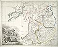
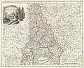
 Русский: Карта 6. Курляндская губерния из 5 уездовEnglish: List 6. Kurlyandskaya Governorate of 5 uyezds
 -
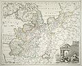
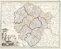
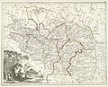
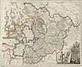
 Русский: Карта 7. Белорусская губерния из 16 уездовEnglish: List 7. Belorusskaya Governorate of 16 uyezds
 -
 Русский: Карта 8. Псковская губерния из 6 уездовEnglish: List 8. Pskovskaya Governorate of 6 uyezds
 -
 Русский: Карта 9. Новгородская губерния из 11 уездовEnglish: List 9. Novgorodskaya Governorate of 11 uyezds
 -
 Русский: Карта 10. Архангелогородская губерния из 8 уездовEnglish: List 10. Arkhangelogorodskaya Governorate of 8 uyezds
 -
 Русский: Карта 11. Вологодская губерния из 10 уездовEnglish: List 11. Vologodskaya Governorate of 10 uyezds
 -
 Русский: Карта 12. Ярославская губерния из 7 уездовEnglish: List 12. Atlas of Russian Empire. 1800 year. List 12. Yaroslavskaya Governorate of 7 uyezds
 -
 Русский: Карта 13. Костромская губерния из 11 уездовEnglish: List 13. Kostromskaya Governorate of 11 uyezds
 -
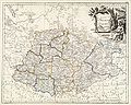
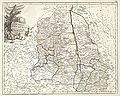
 Русский: Карта 14. Тверская губерния из 9 уездовEnglish: List 14. Tverskaya Governorate of 9 uyezds
 -
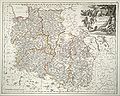
 Русский: Карта 15. Московская губерния из 10 уездовEnglish: List 15. Moskovskaya Governorate of 10 uyezds
 -
 Русский: Карта 16. Смоленская губерния из 9 уездовEnglish: List 16. Smolenskaya Governorate of 9 uyezds
 -
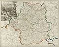
 Русский: Карта 18. Волынская губерния из 12 уездовEnglish: Volinskaya Governorate of 12 uyezds
 -
 Русский: Карта 19. Минская губерния из 10 уездовEnglish: Minskaya Governorate of 10 uyezds
 -
 Русский: Карта 20. Малороссийская губерния из 20 поветовEnglish: List 20. Malorossiyskaya Governorate of 20 powiats
 -
 Русский: Карта 21. Курская губерния из 10 уездовEnglish: List 21. Kurskaya Governorate of 7 uyezds
 -
 Русский: Карта 22. Орловская губерния из 10 уездовEnglish: List 22. Orlovskaya Governorate of 10 uyezds
 -
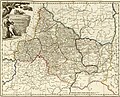
 Русский: Карта 23. Калужская губерния из 9 уездовEnglish: List 23. Kalujskaya Governorate of 9 uyezds
 -
 Русский: Карта 24. Тульская губерния из 9 уездовEnglish: List 24. Tulskaya Governorate of 9 uyezds
 -
 Русский: Карта 25. Рязанская губерния из 9 уездовEnglish: List 25. Ryazanskaya Governorate of 9 uyezds
 -
 Русский: Карта 26. Владимирская губерния из 10 уездовEnglish: List 26. Vladimirskaya Governorate of 10 uyezds
 -
 Русский: Карта 27. Нижегородская губерния из 10 уездовEnglish: List 27. Nijegorodskaya Governorate of 10 uyezds
 -
 Русский: Карта 28. Казанская губерния из 10 уездовEnglish: List 28. Kazanskaya Governorate of 10 uyezds
 -
 Русский: Карта 29. Вятская губерния из 10 уездовEnglish: List 29. Vyatskaya Governorate of 10 uyezds
 -
 Русский: Карта 30. Пермская губерния из 12 уездовEnglish: List 30. Permskaya Governorate of 12 uyezds
 -
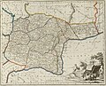 Русский: Карта 31. Оренбургская губернияEnglish: List 31. Orenburgskaya Governorate
 -
 Русский: Карта 32. Симбирская губерния из 10 уездовEnglish: Simbirskaya Governorate of 10 uyezds
 -
 Русский: Карта 33. Саратовская губерния из 10 уездовEnglish: List 33. Saratovskaya Governorate of 10 uyezds
 -
 Русский: Карта 34. Тамбовская губерния из 10 уездовEnglish: List 34. Tambovskaya Governorate of 10 uyezds
 -
 Русский: Карта 35. Воронежская губерния из 9 уездовEnglish: List 35. Voronejskaya Governorate of 9 uyezds
 -
 Русский: Карта 36. Слободская Украинская губерния из 10 уездовEnglish: List 36. Slobodskaya Ukrainskaya Governorate of 10 uyezds
 -
 Русский: Карта 37. Астраханская губерния из 12 уездов и Земли Войска ДонскогоEnglish: List 37. Astrakhanskaya Governorate of 12 uyezds and Land of the Don Army
 -
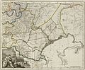
 Русский: Карта 38. Новороссийская губерния из 12 уездовEnglish: List 38. Novorossiyskaya Governorate of 12 uyezds
 -
 Русский: Карта 39. Киевская губерния из 8 уездовEnglish: List 39. Kievskaya Governorate of 8 uyezds
 -
 Русский: Карта 40. Подольская губерния из 12 поветовEnglish: List 40. Podolskaya Governorate of 12 powiats
 -
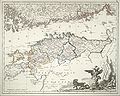
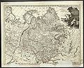 Русский: Карта 41. Тобольская губерния из 16 уездовEnglish: List 41. Tobolskaya Governorate of 16 uyezds
 -
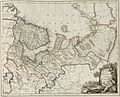
 Русский: Карта 42а. Западная Часть Иркутской губернии из 15 уездовEnglish: List 42a. Western Part of Irkutskaya Governorate of 15 uyezds
 -
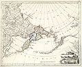 Русский: Карта 42б. Восточная часть губерния из 2 уездов, чукотской земли с прилежащими островами и западными берегами АмерикиEnglish: List 42b. Eastern part of Irkutskaya Governorate of 2 uyezds, Chukotka land with adjacent islands and western shores of America


._Courland_Governorate.jpg)
._Belorussian_governorate.jpg)


._Tver_governorate.jpg)


._Volyn_governorate.jpg)


._Kaluga_governorate.jpg)
._Tula_governorate.jpg)


._Orenburg_governorate.jpg)
._Simbirsk_governorate.jpg)
._Saratov_governorate.jpg)


._Kiev_governorate.jpg)
._Podolia_governorate.jpg)


Media in category "Atlas of the Russian Empire (1800)"
The following 74 files are in this category, out of 74 total.
-
RussianEmpireMap1800-38-NovorossiyskayaProvince.jpg 9,464 × 7,721; 15.31 MB
-
 Atlas of Russian Empire (1800). Arkhangelsk governorate.jpg 8,858 × 7,162; 9.94 MB
-
 Atlas of Russian Empire (1800). Astrakhan governorate.jpg 8,858 × 7,271; 10.17 MB
-
Atlas of Russian Empire (1800). Belorussian governorate.jpg 8,858 × 7,151; 10.34 MB
-
Atlas of Russian Empire (1800). Courland Governorate.jpg 8,858 × 7,112; 8.84 MB
-
 Atlas of Russian Empire (1800). Estlandia governorate.jpg 8,858 × 7,186; 9.07 MB
-
Atlas of Russian Empire (1800). Kaluga governorate.jpg 8,858 × 7,166; 10.2 MB
-
 Atlas of Russian Empire (1800). Kazan governorate.jpg 8,858 × 7,190; 10.06 MB
-
Atlas of Russian Empire (1800). Kiev governorate.jpg 8,858 × 7,165; 9.15 MB
-
 Atlas of Russian Empire (1800). Kostroma governorate.jpg 8,858 × 7,174; 10.27 MB
-
 Atlas of Russian Empire (1800). Kursk governorate.jpg 8,858 × 7,169; 10 MB
-
 Atlas of Russian Empire (1800). Liflandia governorate.jpg 8,858 × 7,227; 9.07 MB
-
 Atlas of Russian Empire (1800). Lithuanian governorate.jpg 8,858 × 7,145; 10.27 MB
-
 Atlas of Russian Empire (1800). Malorossian governorate.jpg 8,858 × 7,117; 10 MB
-
 Atlas of Russian Empire (1800). Moscow governorate.jpg 8,858 × 7,211; 10.67 MB
-
 Atlas of Russian Empire (1800). Nizhny Novgorod governorate.jpg 8,858 × 7,177; 9.84 MB
-
 Atlas of Russian Empire (1800). Novgorod governorate.jpg 8,858 × 7,221; 10.44 MB
-
 Atlas of Russian Empire (1800). Novorossiysk governorate.jpg 8,858 × 7,186; 10.12 MB
-
Atlas of Russian Empire (1800). Orenburg governorate.jpg 8,858 × 7,133; 9.89 MB
-
 Atlas of Russian Empire (1800). Oryol governorate.jpg 8,858 × 7,151; 9.78 MB
-
 Atlas of Russian Empire (1800). Perm governorate.jpg 8,858 × 7,216; 10.89 MB
-
Atlas of Russian Empire (1800). Podolia governorate.jpg 8,858 × 7,098; 8.85 MB
-
 Atlas of Russian Empire (1800). Pskov governorate.jpg 8,858 × 7,223; 11.5 MB
-
 Atlas of Russian Empire (1800). Ryazan governorate.jpg 8,858 × 7,195; 9.44 MB
-
 Atlas of Russian Empire (1800). Saint Petersburg governorate.jpg 8,858 × 7,198; 9.9 MB
-
Atlas of Russian Empire (1800). Saratov governorate.jpg 8,858 × 7,097; 10.36 MB
-
Atlas of Russian Empire (1800). Simbirsk governorate.jpg 8,858 × 7,126; 11.28 MB
-
 Atlas of Russian Empire (1800). Slobodskaya governorate.jpg 8,858 × 7,138; 9.06 MB
-
 Atlas of Russian Empire (1800). Smolensk governorate.jpg 8,858 × 7,201; 10.09 MB
-
 Atlas of Russian Empire (1800). Tambov governorate.jpg 8,858 × 7,124; 10 MB
-
 Atlas of Russian Empire (1800). Title page.jpg 2,953 × 2,585; 1.61 MB
-
 Atlas of Russian Empire (1800). Tobolsk governorate.jpg 8,858 × 7,189; 11.22 MB
-
Atlas of Russian Empire (1800). Tula governorate.jpg 8,858 × 7,179; 10.05 MB
-
Atlas of Russian Empire (1800). Tver governorate.jpg 8,858 × 7,175; 12.92 MB
-
 Atlas of Russian Empire (1800). Vladimir governorate.jpg 8,858 × 7,150; 10.41 MB
-
 Atlas of Russian Empire (1800). Vologda governorate.jpg 8,858 × 7,175; 9.56 MB
-
Atlas of Russian Empire (1800). Volyn governorate.jpg 8,858 × 7,168; 9.95 MB
-
 Atlas of Russian Empire (1800). Voronezh governorate.jpg 8,858 × 7,238; 9.42 MB
-
 Atlas of Russian Empire (1800). Vyatka governorate.jpg 8,858 × 7,150; 10.22 MB
-
 Atlas of Russian Empire (1800). Wyborg Governorate.jpg 8,858 × 7,229; 10.01 MB
-
 Atlas of Russian Empire (1800). Yaroslavl governorate.jpg 8,858 × 7,218; 10.55 MB
-
RussianEmpireMap1800-00a-title-page.jpg 4,000 × 6,126; 4.11 MB
-
RussianEmpireMap1800-00b-table-of-contents.jpg 4,000 × 6,000; 2.35 MB
-
RussianEmpireMap1800-02-SankpeterburgskayaProvince.jpg 4,000 × 3,230; 1.89 MB
-
RussianEmpireMap1800-03-ViborgskayaProvince.jpg 4,000 × 3,186; 1.76 MB
-
RussianEmpireMap1800-04-EstlyandskayaProvince.jpg 4,000 × 3,204; 1.77 MB
-
RussianEmpireMap1800-05-LiflyandskayaProvince.jpg 4,000 × 3,256; 1.67 MB
-
RussianEmpireMap1800-08-PskovskayaProvince.jpg 4,000 × 3,212; 2.13 MB
-
RussianEmpireMap1800-09-NovgoroskayaProvince.jpg 4,000 × 3,230; 2 MB
-
RussianEmpireMap1800-10-ArkhangelskayaProvince.jpg 4,000 × 3,240; 1.89 MB
-
RussianEmpireMap1800-11-VologodskayaProvince.jpg 4,000 × 3,230; 1.83 MB
-
RussianEmpireMap1800-12-YaroslavskayaProvince.jpg 4,000 × 3,244; 1.96 MB
-
RussianEmpireMap1800-13-KostromskayaProvince.jpg 4,000 × 3,200; 1.99 MB
-
RussianEmpireMap1800-15-MoskovskayaProvince.jpg 4,000 × 3,224; 2.1 MB
-
RussianEmpireMap1800-16-SmolenskayaProvince.jpg 4,000 × 3,212; 1.94 MB
-
RussianEmpireMap1800-19-MinskayaProvince.jpg 4,000 × 3,224; 2.25 MB
-
RussianEmpireMap1800-20-MalorossiyskayaProvince.jpg 4,000 × 3,236; 2.14 MB
-
RussianEmpireMap1800-21-KurskayaProvince.jpg 4,000 × 3,250; 2.06 MB
-
RussianEmpireMap1800-22-OrlovskayaProvince.jpg 4,000 × 3,232; 1.93 MB
-
 RussianEmpireMap1800-24a-TulskayaProvince.jpg 2,000 × 1,614; 945 KB
-
RussianEmpireMap1800-25-RyazanskayaProvince.jpg 4,000 × 3,206; 1.82 MB
-
RussianEmpireMap1800-26-VladimirskayaProvince.jpg 4,000 × 3,206; 2.02 MB
-
RussianEmpireMap1800-27-NijegorodskayaProvince.jpg 4,000 × 3,232; 2.1 MB
-
RussianEmpireMap1800-28-KazanskayaProvince.jpg 4,000 × 3,240; 1.92 MB
-
RussianEmpireMap1800-29-VyatskayaProvince.jpg 4,000 × 3,214; 2.03 MB
-
RussianEmpireMap1800-30-PermskayaProvince.jpg 4,000 × 3,208; 2.12 MB
-
 RussianEmpireMap1800-32-SimbirskayaProvince-crop.jpg 945 × 1,207; 369 KB
-
RussianEmpireMap1800-34-TambovskayaProvince.jpg 4,000 × 3,240; 2.05 MB
-
RussianEmpireMap1800-35-VoronejskayaProvince.jpg 7,341 × 5,970; 9.69 MB
-
RussianEmpireMap1800-36-SlobodskayaUkrainskayaProvince.jpg 4,000 × 3,214; 1.83 MB
-
RussianEmpireMap1800-37-AstrakhanskayaProvince.jpg 4,000 × 3,244; 1.75 MB
-
RussianEmpireMap1800-41-TobolskayaProvince.jpg 7,661 × 6,230; 10.3 MB
-
RussianEmpireMap1800-42b-IrkutskayaProvinceEast.jpg 4,000 × 3,244; 1.55 MB
-
RussianEmpireMap1800-42а-IrkutskayaProvinceWest.jpg 4,000 × 3,204; 1.98 MB
._Arkhangelsk_governorate.jpg)
._Astrakhan_governorate.jpg)
._Estlandia_governorate.jpg)
._Kazan_governorate.jpg)
._Kostroma_governorate.jpg)
._Kursk_governorate.jpg)
._Liflandia_governorate.jpg)
._Lithuanian_governorate.jpg)
._Malorossian_governorate.jpg)
._Moscow_governorate.jpg)
._Nizhny_Novgorod_governorate.jpg)
._Novgorod_governorate.jpg)
._Novorossiysk_governorate.jpg)
._Oryol_governorate.jpg)
._Perm_governorate.jpg)
._Pskov_governorate.jpg)
._Ryazan_governorate.jpg)
._Saint_Petersburg_governorate.jpg)
._Slobodskaya_governorate.jpg)
._Smolensk_governorate.jpg)
._Tambov_governorate.jpg)
._Title_page.jpg)
._Tobolsk_governorate.jpg)
._Vladimir_governorate.jpg)
._Vologda_governorate.jpg)
._Voronezh_governorate.jpg)
._Vyatka_governorate.jpg)
._Wyborg_Governorate.jpg)
._Yaroslavl_governorate.jpg)

