Category:Armouth Wath
Jump to navigation
Jump to search
English: Armouth Wath, at the top southern head of the Baysdale Valley, between Ingleby and Baysdale Moors
Media in category "Armouth Wath"
The following 4 files are in this category, out of 4 total.
-
 Small Pile of Coal - geograph.org.uk - 712936.jpg 640 × 480; 153 KB
-
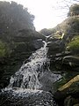 Small Waterfall at Armouth Wath - geograph.org.uk - 712911.jpg 480 × 640; 88 KB
-
 Armouth Wath - geograph.org.uk - 26646.jpg 640 × 480; 61 KB
-
 Grain Beck, Upper Baysdale - geograph.org.uk - 30142.jpg 640 × 480; 60 KB


