Category:Arctic sea ice extent
Jump to navigation
Jump to search
Subcategories
This category has only the following subcategory.
M
Media in category "Arctic sea ice extent"
The following 41 files are in this category, out of 41 total.
-
 134721main3 seaice min 1979 250.jpg 250 × 188; 51 KB
-
 134723main3 seaice min 2005 250.jpg 250 × 188; 51 KB
-
 2012 Arctic Ice Extent-aug25.png 1,050 × 840; 456 KB
-
2013 Daily Arctic Sea Ice from AMSR2 May - September 2013 01.webm 30 s, 640 × 360; 1.59 MB
-
2013 Daily Arctic Sea Ice from AMSR2 May - September 2013 02.webm 30 s, 1,280 × 720; 4.08 MB
-
2013 Daily Arctic Sea Ice from AMSR2 May - September 2013 03.webm 30 s, 1,920 × 1,080; 7.8 MB
-
 2013 Daily Arctic Sea Ice from AMSR2 May - September 2013 STILL IMAGE.png 5,760 × 3,240; 18.49 MB
-

-
 20210125 The Cryosphere - Floating and grounded ice - imbalance - climate change.png 1,889 × 1,288; 96 KB
-
Approaching the 2011 Arctic Sea Ice Minimum.ogv 35 s, 1,280 × 720; 17.73 MB
-
 Arcmosaic tmo 2007259.png 540 × 540; 535 KB
-
 Arctic daily sea ice extent 20240314p hnsidc 2024 plot.jpg 720 × 348; 101 KB
-
 Arctic ice-pack from September 2002-2006.gif 420 × 500; 38 KB
-
 Arctic nsidc 2023262 plot.jpg 720 × 499; 114 KB
-
 Arctic sea ice decline 2015 May NSIDC.png 3,300 × 2,550; 326 KB
-
 Arctic sea ice extent.png 1,050 × 840; 275 KB
-
 Arctic sea ice reaches lowest maximum extent on record.png 1,050 × 840; 329 KB
-
 Arctic Sea Ice Shrinks.jpg 670 × 377; 211 KB
-
 Arctic sea ice volume progression since1979 animation.gif 692 × 737; 1.01 MB
-
 Arctic sea ice volume progression since1979.png 620 × 661; 296 KB
-

-
 Average Monthly Arctic Sea Ice Extent - September 1979 - 2012.png 2,807 × 2,100; 236 KB
-

-
 Climate change - Arctic sea ice extent.png 3,400 × 2,400; 445 KB
-
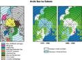
 Climatology 81-10 min-max conc tmb.png 406 × 512; 115 KB
-

-
Interpretation of the 2011 Sea Ice Record.ogv 3 min 46 s, 640 × 360; 43.01 MB
-
 NASA Finds Thickest Parts of Arctic Ice Cap Melting Faster (6941907057).jpg 3,840 × 4,392; 1 MB
-
 NASA NH decadal ice extent 2022.png 720 × 932; 284 KB
-
 North pole february ice-pack 1978-2002.png 976 × 974; 98 KB
-
North Pole Sea Ice 1990-1999.ogv 1 min 59 s, 320 × 240; 8.86 MB
-
 Northern Hemisphere Sea Ice Extent Anomalies-Aug.png 1,260 × 720; 245 KB
-
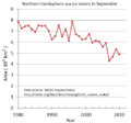 NorthernHemisphere-SeaIceExtent-trend-sep.png 520 × 484; 21 KB
-
 NSIDC arctic sea ice extent since 1979.svg 810 × 540; 37 KB
-
 Opposite Behaviors? Arctic Sea Ice Shrinks, Antarctic Grows.jpg 670 × 322; 140 KB
-
 Plot arctic sea ice volume.svg 810 × 540; 43 KB
-
 Poolijs 1990.jpg 648 × 486; 28 KB
-
 Puzzle arctic sea ice extents.gif 686 × 501; 76 KB
-
Sea Ice Yearly Minimum 1979-2012 (SSMI data) with Graph.ogv 39 s, 1,920 × 1,080; 8.14 MB
-
Summer Arctic Sea Ice Retreat - May - August 2013.ogv 23 s, 1,920 × 1,080; 2.44 MB
-
 Total arctic 1978 2007 n TN.gif 300 × 250; 10 KB


_of_the_different_global_ice_components,_total_floating_ice,_total_grounded_ice_and_global_total_per_decade_and_over_the_common_period_1994%E2%80%932017.png)

_Southern_Hemisphere_and_(b)_Northern_Hemisphere.png)


_and_grounded_(purples)_components.png)
.jpg)


